.webp)
.webp)
.webp)
.webp)
Hampta Pass Trek
.webp)
.webp)
.webp)
Hampta Pass Trek

Region
Himachal Pradesh | India

Duration
5 Days

Max Altitude
14100 Ft.

Trekking Km
24 KM

Grade
Moderate
Get in Touch with Our Trek Expert
91 90456 54448 info@trekthehimalayas.comMonday - Saturday: 10 AM to 06 PM (GMT +5:30)
12500 /Person
- July-2025
- August-2025
- September-2025
- 5% GST will be applicable on Trek Cost and Add-ons
- Services Manali to Manali | Included Transport
- Reporting Point: All trekkers must report to the Woodbine Hotel in Manali.
- Drop Point Manali Bus Station.
- Reporting Time: 12:00 PM
- Drop Time:6:30 pm to 7:30 pm (Timings are subject to change based on weather and road conditions).
- Please reach Manali a day before to avoid any delays.
Add-ons
Insurance 175
- Insurance is mandatory.
- It is available for Indian citizens only.
- Non-Indians have to take insurance on their own.
- If you already have the high altitude trekking insurance, email for a refund after booking.
- The cancellation policy will be implemented in accordance with the trek cancellation policy.
- For more details about insuranceclick here
Offload 1500
- Backpack offload is optional.
- Choose add-ons during booking. If missed, log in and add them later.
- Book off-load at least 10 days before the trek.
- For offline bookings at the base camp, a convenience fee of Rs. 2000 applies.
- Cancellations made before the trip date will receive a full refund.
Get in Touch with Our Trek Expert
91 90456 54448info@trekthehimalayas.com
Monday - Saturday: 10 AM to 06 PM (GMT +5:30)
Overview
Trek Name: Hampta Pass Trek
Days: 5
Adventure Type: Trekking
Base Camp: Manali
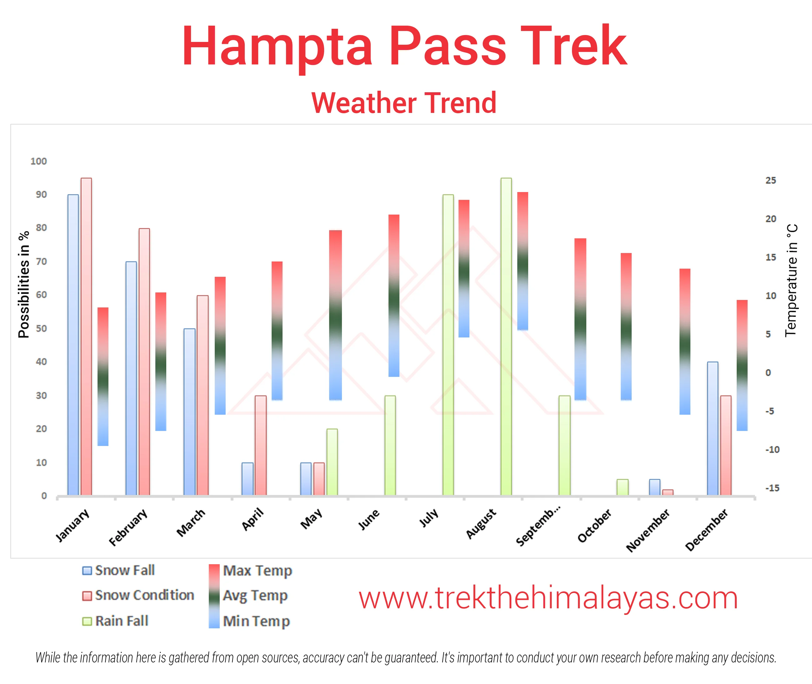
Season:Monsoon |
Month:June | July | August | September |
Country: India
Altitude: 14100 Ft.
Grade: Moderate
Rail Head: Chandigarh is the nearest rail head to the base camp
Stay: Camping (Twin sharing)
Food: Meals while on trek (Veg + Egg)
Location: Himachal Pradesh
Distance: 24 Km.
Trail Type: Cross over trail | Start in one valley, traverse the pass, and ends in another valley.
AirPort: Bhuntar, which is 52 km away from Manali
Highlights:
- 5% GST will be applicable on Trek Cost and Add-ons
- Services Manali to Manali | Included Transport
- Reporting Point: All trekkers must report to the Woodbine Hotel in Manali.
- Drop Point Manali Bus Station.
- Reporting Time: 12:00 PM
- Drop Time:6:30 pm to 7:30 pm (Timings are subject to change based on weather and road conditions).
- Please reach Manali a day before to avoid any delays.
Why is Hampta Pass a Must- Do Trek?
- Hampta Pass is a high-altitude crossover trek that connects the lush green Kullu Valley to the stark, arid landscapes of the Lahaul region.
- The dramatic shift in scenery during this trek is nothing short of stunning, with every day bringing a new backdrop.
- Stream crossings add a thrill to the adventure, especially as you wade through icy, gushing waters using ropes for support.
- Standing at over 14,000 ft, the view from Hampta Pass showcases towering peaks and dramatic valleys.
- The close-up views of Mt. Indrasan and Mt. Deo Tibba are a visual treat for mountain lovers and photography enthusiasts alike.
- Each campsite like Shea Goru, Chhika, and Balu Ka Ghera, is scenically placed, surrounded by mountains and streams.
- The trek offers a moderate challenge, making it ideal for beginners with good preparation who want to experience a high-altitude pass without extreme difficulty.
- A major highlight of Hampta Pass trek is the visit to the stunning Chandratal Lake, a crescent-shaped alpine lake with unreal blue hues.
- During the summer and monsoon months, the valley blooms with vibrant wildflowers and diverse wildlife.
.webp)
Who Can Participate
- Age Requirement:
- Minimum 12 years
- First-timers are welcome, though prior trekking experience is preferred. Good fitness is a must.
- Fitness Criteria:
- If the trekker wants to carry a backpack then he/she should be able to carry a 10-12 kg backpack. If opt Off-load option then the trekker should be able to carry 3-5 kg backpack.
- If a trekker's BMI is more or less than the normal range (18-28), please consult our Trek Coordinator before booking.
Special Offer
Special Offer: Trek As Many Times as You Want!
At Trek The Himalayas, we understand that sometimes the unexpected happens, and you may not be able to complete your trek. Whether you are unable to finish the trek, or you’ve successfully completed it and want to experience it again, we have a special offer for you!
Make a single payment and trek the number of times you want.
Terms and Conditions:
- This offer is non-transferable.
- Valid only for Trek The Himalayas limited fixed departures.
- The offer is valid for 5 years from the trek departure date.
- The offer does not apply if the participant has received a cash refund or voucher at the time of cancellation or transferred the trek.
- Participants are not required to pay for the trek cost again, but will need to cover transportation and trek permit costs.
- To reserve your spot, you can use our online booking form or simply give us a call. A deposit must be wired, including the initial payment, for confirmation.
- Offer will be activate once participant reach trek base camp/meeting point.
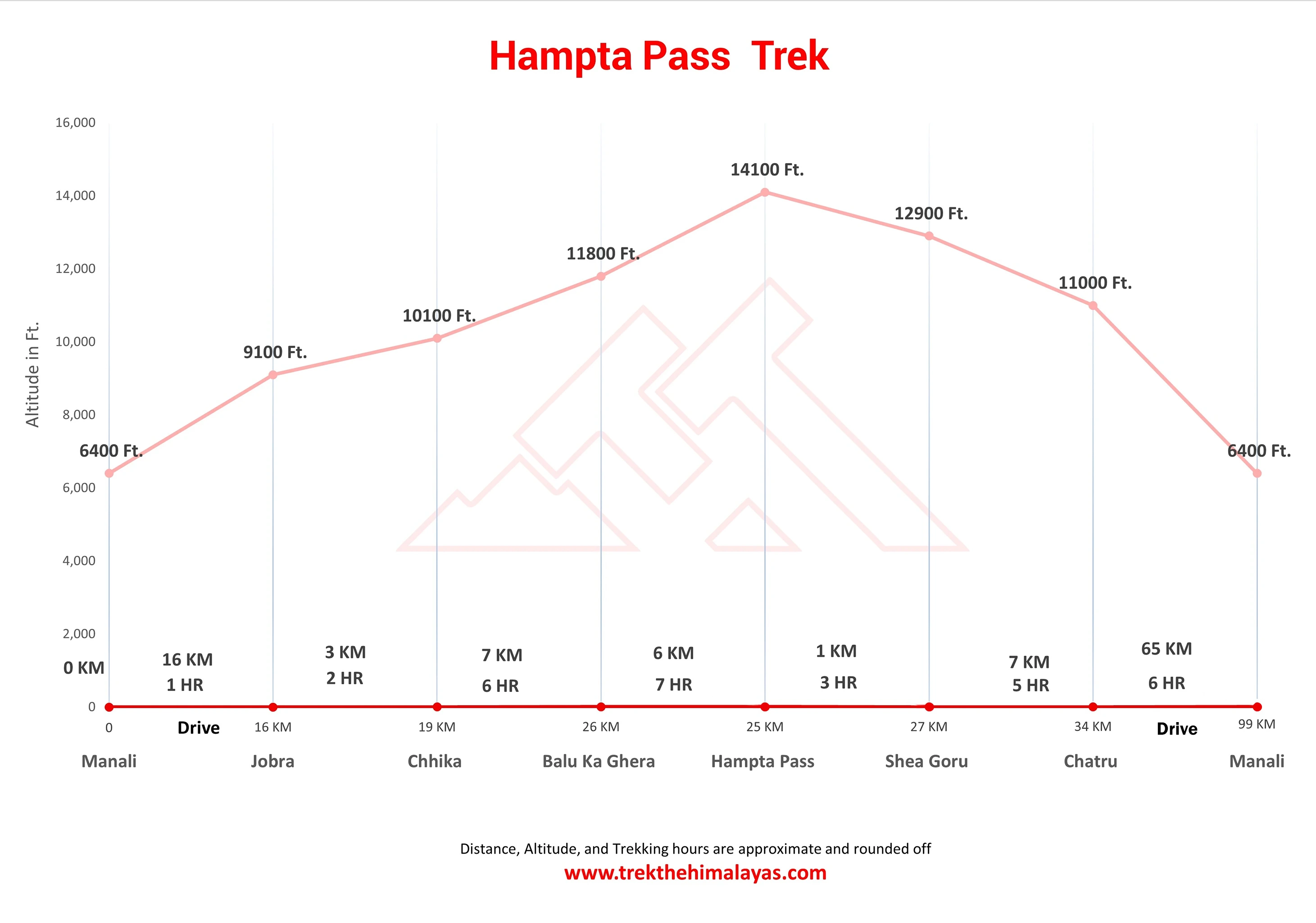
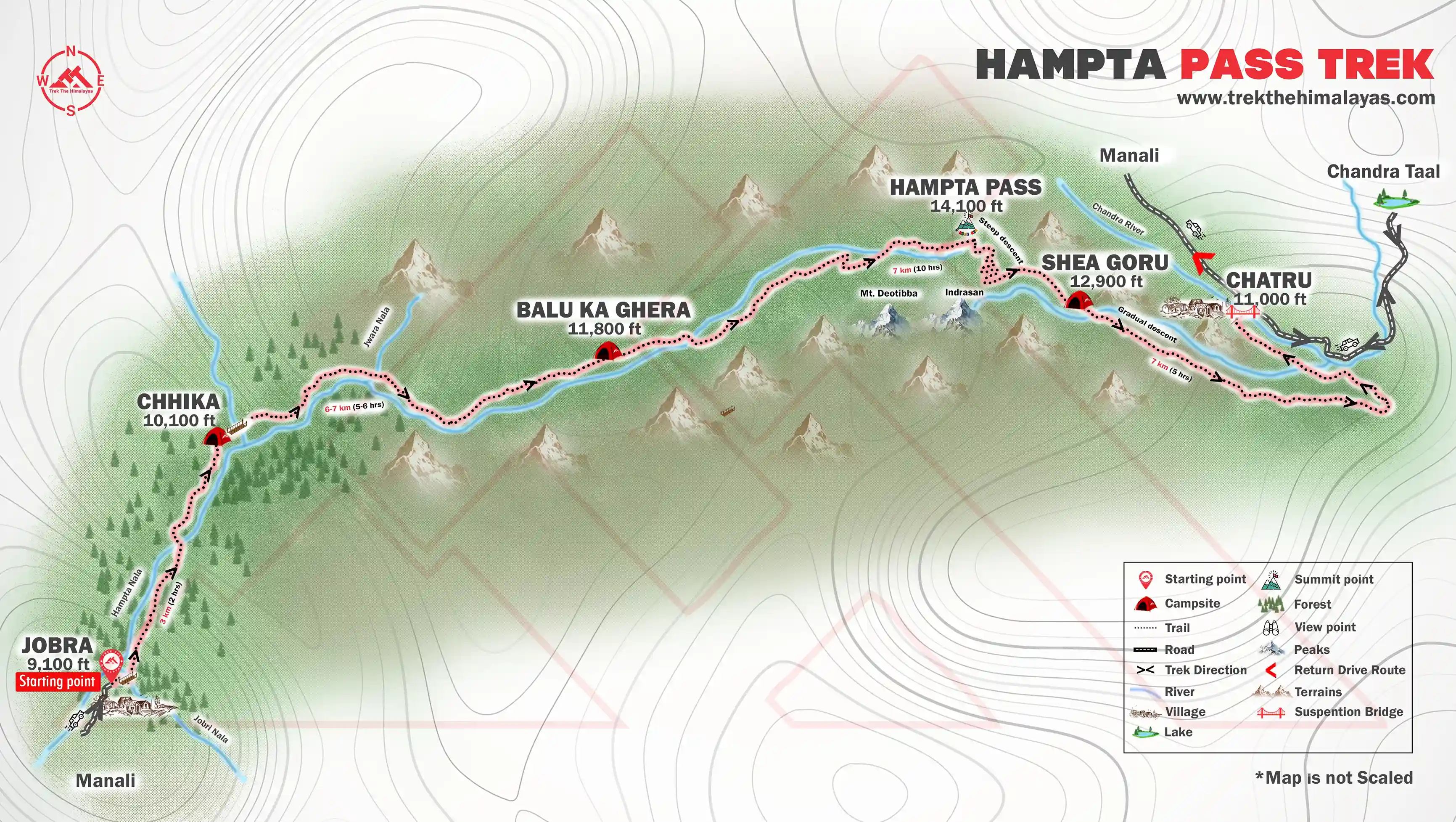
Hampta Pass Trek Itinerary
Manali To Chhika Via Jobra | Walk Through Forest Cover
- Altitude:
Manali - 2,100 m / 6,400 ft
Jobra - 2,800 m / 9,100 ft
Chhika 3,100 m / 10,100 ft. - Drive Distance (Manali to Jobra): 16km | 1hr.
- Trek Distance (Jobra to Chhika): 3km | 2hrs.
- Enough water through the trail.
- Easy to moderate trail.
- Stay in a tent
- Meeting Time and Place: 12 pm at The Woodbine, Naggar Rd, Manali, Himachal Pradesh 175131.
- Reach Chhika campsite by 5 pm.
The trekking expedition starts at Manali where you will be driven to Jobra in a vehicle. Manali lies at an elevation of 6,300 ft. so it is a good place to acclimatize before you start the trek. The drive takes you along 40 hairpin bends before you arrive at Jobra, the drive time is around 2 hrs. You will get to see the beauty of the Kullu Valley all along the ride. Jobra is the base for your trek to Hampta Pass. It is situated at an altitude of 9,200 ft and the trek to Chhika will take you to an altitude of 10,100 ft.
Today is an easy trek along the banks of Rani Nallah through a mixed forest of pine, green maple, and birches. The trek initiates from Allain Guhugal Hydel Project junction and after you cross the main road, you follow the small path leading into a forest of Pine trees and other conifers like Maple, Oak, Deodar, and Toss. The slope that you will climb is not steep and is quite easy to climb. The surroundings are very beautiful, take a moment to appreciate the beauty of the environs before heading into a lush meadow strewn with small rocks all around. Twenty minutes into the trek and you will arrive at the bend that overlooks the meadow.
A little into the meadow the Rani Nallah comes into view, it flows through the middle of the meadow making it look like a picture right out of a fairytale. Walk through the meadow or climb up the hill on the left-hand side, either way, you will reach Chhika at the end of the vast meadow. Climbing the hill and descending to Chhika is the easier route and the campsite lies in a huge patch of a green clearing. Rani River flows through the middle, which makes the perfect setting to pitch up a tent. You may also spot horses grazing in the meadows that make a perfect setting for some Instagram-worthy photographs.

Chhika To Balu Ka Ghera | Stay At A Beautiful Campsite
- Altitude: 3,600 m/ 11,800 ft.
- Trek Distance: 6-7km | 5-6 hrs.
- Altitude Gain: 700 m/ 2300 ft.
- Moderate trail, gradual ascent.
- A packed lunch will be provided.
- Enough water on the way.
- River crossing, boulder walk, and colorful tiny flowers on the way.
The next destination is Balu Ka Ghera. While the area is not visible from the Chhika campsie, from the direction of the trail you can guess that it falls on the right-hand side. The trail will lead through boulders and rough terrain and the grade of the trek today is also an easy one and can be completed without any difficulty.
The entire stretch of the river's right bank is lined up with amazing dwarf Rhododendron trees. These trees will cover the lower and the central region and a cluster of silver birch trees cover up the upper region. Once you have reached the end of the silver birch trees, wait a moment and look back to marvel at the entire range of Dhauladhar snow-clad peaks in front of you. The view is very picturesque. You will reach a clear stream waterfall to the left at a distance. This is the best place to fill your bottles.
After crossing the waterfall, the next route is towards the river to your left. You can go to the other side only by crossing the river but you will have to wet your feet. Fair warning, the water is super cold and will prick your feet. You can also jump from one rock to another in the stream and get to the opposite side. You must have finished half of the day's trek when you enter Jwara. Jwara is a beautiful scenic sheltered valley; with huge snow-clad rocks at one side and the valley drops down to the river on the other side. You will feel like immersing yourself in the beauty of God's nature. You will find snow melting into the river and cattle grazing the land.
In front of you are snow-clad mountains. From here, the trail entwines along the riverside which will lead you to another rectangular valley. The path is covered with multi-colored flowers. The last of the tree lines vanish out of sight and are left behind. It will take another half an hour or so to reach the end of the valley, which is the finishing part of Jwara. After Jwara, the path is a slope covered with snow and rocks. You will spot a variety of purple, yellow, and pink wildflowers along the way. The terrain flattens out as you progress towards Balu Ka Ghera. You have to walk along a path of rocks and boulders and the rocks become more and more sparse as you progress towards Balu Ka Ghera.
Balu ka Ghera marks the end of the path, the name has nothing to do with the place. The place is covered with snow and greens whereas the name implies a mound of sand. But it is said that this place was formed with the sands and dust deposited by the river and hence the name. Balu ka Ghera campsite is a flat ground amidst the mountains that you will cross the next day to reach the pass. Balu ka Ghera is at an elevation of 12,400 ft.

Balu Ka Ghera To Shea Goru | Panoramic Mountain Views
- Altitude: Hampta Pass - 4,300 m / 14,100 ft | Shea Goru- 3,900 m/ 12,900 ft
- Trek Distance: 7 km | Duration: 10 hr
- Altitude Gain: 520 m/ 1,700 ft.
- No water point on the way (depends on the condition of snow)
- First 1 hr gradual ascent then steep ascent till the pass
- Packed lunch at the pass, enjoy the view of Indrasen Peak
- Around 2 hrs of steep descent and 1 hr of flat walk from the pass to the campsite
- The coldest part of the trek
- Stay in a tent.
You can split the journey into two halves, a steady ascent on a moderately steep slope to Hampta Pass, hence a sharp descent to Shea Goru. The highest altitude will be achieved on this day at Hampta Pass (14,100 ft). The day starts by heading towards the mountains you spotted the previous day near Balu Ka Ghera. The trail is along the riverside. The view is amazing, tiny yellow and orange flowers along the river banks enhance its beauty.
The riverside trails take you further to the base followed by the actual climb to the Hampta pass. The trail fades out at some point so be mindful to not get lost. When trekking with us, our trek leaders will lead you through the right trail so no worries about wandering away. It will take an hour to reach here. Another hour of the walk will take you to the first plateau. In summer, the place is completely covered with thick fresh snow. Otherwise, it is just patches of snow everywhere.
You will reach another plateau and onto a ridge. It will take another half an hour to reach the ridge's end. Then from the first ridge trek further up to the second ridge. Hampta Pass is just a few meters and a bend away from the second ridge. The climb to Hampta Pass is a vertical one and is a hard mount. It will take about 15 minutes to reach the pass. Yes, by the time you reach there, you will be extremely tired but the site which unfolds in front of you is supremely stunning. Enjoy for some time in the pass, relish the beauty around, have your lunch and then get ready for the next descent to Shea Goru.
The descent is trickier than the journey to the pass. The decline is so steep that you would not be able to locate the base of the mountain, not even by craning your neck. The best possible way to get down is either by sliding down the slope if there is snow or with the use of ropes for support. The route is a little meandering too. You will also spot Spiti from this point. In an hour and a half, a final u-turn will bring you to the base of the valley and the trail ahead will lead you to Shea Goru. The valley is secured by snow-clad mountains, and the side which is open is way to Shea Goru. The trek to Shea Goru is easy and on flat land. The river again flows to your right. Like Balu Ka Ghera, the Shea Goru campsite is also by the riverside. Set your camps on the grounds and retire for the night with a feeling of contentment at the heart.

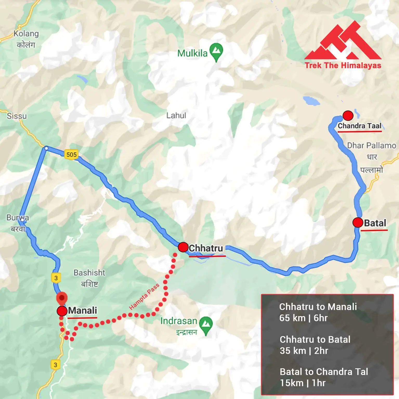
Shea Goru To Chatru And Drive To Chandratal | Bask In the Serenity Of The Lake
- Altitude: Chatru- 3,350 m/ 11,000 ft.
- Trek Distance: 7 km | 5 hr.
- Drive Distance: 50 km, 3-4 hr to Chandratal and back to the campsite, either on day 4 or day 5 (depending on road and weather conditions).
- Altitude Loss: 550 m/ 1,900 ft.
- Gradual descent on the moraine.
- Start early in the morning.
- 2 to 3 water sources on the way.
- Hot lunch at campsite.
You will cover Shea Goru to Chatru by foot and it will take approx 5 hours of easy downhill trek. Shea Goru is placed at an altitude of 12,900ft and Chatru at 11, 000ft. It is a gentle trek downhill from Shea Goru. The trail here again is by the side of the river valley between mountain ranges. Some places can be a little slippery so be careful.
Chatru can be located at a distance. No vegetation can be seen in the barren mountains. The tricky part comes next. You will have to be careful as the trail might sometimes lead you to the edges of mountains and ridges. The route has slippery parts too. So, sure-footed and careful navigation is required to go further. Nevertheless, the trek is not as difficult as it sounds. You will for sure enjoy the sliding. Getting down the mountains will consume another two hours of your time. You will notice the Chandra River flowing below and a road that goes by its side. More than two Glaciers come next which are to be crossed. The other side of the Glacier is Chatru, the next camping zone. Choose a location that has the river running around.
Chatru is a magnificent camping site; it is a consensus of the three passes, Hampta, Rohtang, and Spiti. The location is just about another two hours away.

Chatru To Manali | Bid Adieu To The Mountains
- Drive Distance: 65 km | Duration: 5-6 hr.
- Breakfast at the campsite.
- Lunch on the way (not included in cost).
- Make your further travel plans from Manali.
It is time to say goodbye to the Spiti Valley and head back to Manali. A ride back from the Chatru campsite to Manali is scheduled for day 5. After this 5 hour journey full of mellow reminisces of the hills, you will be reaching Manali in the afternoon. An overnight journey after 08:00 pm to Delhi will hopefully work out best.
Chandratal Lake
A visit to Chandratal will be either on Day 4 or Day 5. You can hike up to the marvelous Chandratal Lake (known as the moon lake). Chandratal Lake is 50 km from Chatru campsite. The sheer blue color of the lake has an amazing effect on the surroundings. You can visit Chandratal only in the summer months if road and weather condition permits us. If not, you will have to drive directly from Chatru to Manali and skip Chandratal altogether.

Day-1: Manali To Chhika Via Jobra | Walk Through Forest Cover
- Altitude:
Manali - 2,100 m / 6,400 ft
Jobra - 2,800 m / 9,100 ft
Chhika- 3,100 m / 10,100 ft. - Drive Distance (Manli to Jobra): 16km | 1hr.
- Trek Distance (Jobra to Chhika): 3km | 2hrs.
- Reporting Time: 12:00 PM Drop Time: 6:30 pm to 7:30 pm (Timings are subject to change based on weather and road conditions). Please reach Manali a day before to avoid any kind of delays.
Day-2: Chhika To Balu Ka Ghera | Stay At A Beautiful Campsite
- Altitude: 3,600 m/ 11,800 ft.
- Trek Distance: 6-7km | 5-6 hrs.
Day-3: Balu Ka Ghera To Shea Goru | Panoramic Mountain Views
- Altitude: Hampta Pass - 4,300 m / 14,100 ft | Shea Goru- 3,900 m/ 12,900 ft
- Trek Distance: 7 km | Duration: 10 hr
- Altitude Gain: 520 m/ 1,700 ft.
Day-4: Shea Goru To Chatru And Drive To Chandratal | Bask In the Serenity Of The Lake
- Altitude: Chatru- 3,350 m / 11,000 ft.
- Trek Distance: 7 km | Duration: 5 hr.
- Drive Distance: 50 km, 3-4 hr to Chandratal and back to the campsite, either on day 4 or day 5 (depending on road and weather conditions).
Day-5: Chatru To Manali | Bid Adieu To The Mountains
- Drive Distance: 65 km | Duration: 5-6 hr.
Note:
You can visit Chandratal if road and weather condition permits us. If not, you will have to drive directly from Chatru to Manali and skip Chandratal altogether.
Note:
- Keep a buffer day in your travel plan.
- If buffer day is not used in the travel then it can be used to Explore Manali.
- Read the article Things to do in Manali.
- Distance, Altitude, and Trekking hours are approximate and rounded off.
- Keep the original and copy of ID proof handy.
- Come one day early if planning to come by flight.
Hampta Pass Trek Graph
- Pulse rate at rest must be in between (60 to 90 beats per minute).
- Blood Pressure Reading must be in between (DIASTOLIC 70 – 90, SYSTOLIC 100 - 140 mm Hg).
- Respiratory rate at rest must be in between (12 to 20 breaths per minute).
- Should not have Liver and kidney issues.
- Should not have Diabetes Mellitus, Bronchial Asthma, Heart problems, Hypertension, etc.
- No pacemaker implant.
- People with Sinus issues, Epilepsy please contact to trek coordinator before booking the trek.
- If your BMI is not normal, Please contact our Trek coordinator before Trek booking.
Medical & Disclaimer Form (Mandatory Documents) Click here to download Medical & Disclaimer Form
- Government Employees can avail the benefit of Special Casual Leave (SCL) when they join us for a trekking expedition. As per the rules of the Pay Commission, Special Casual Leave can be availed for up to 30 days in a calendar year for trekking/mountaineering expeditions through a registered organization. Trek The Himalayas is a registered adventure tour operator by the Indian Mountaineering Foundation (IMF) and the Ministry Of Tourism (MOT).
- Trekkers have to apply for leave at least 20 days before the trek departure date.
- This service is exclusive to Indian government employees and is applicable only for treks within India.
- Do mail at info@trekthehimalayas to apply and mention your booked trek date and trek name.
- Junior trekkers (below 15 years) should have a company of parents/guardians.
- Trekkers between 15 to 18 years can come solo with the disclaimer form signed by parent/guardian.
- Medical & Disclaimer Form (Mandatory Documents) Click here to download Medical & Disclaimer Form
Important Links
- Mandatory Documents to Bring on A Trek Click Here.
- How to pay Add-ons, Submit Medical Forms, and Dietary Preferences Click Here to watch Video
How To Reach
Pick UP Information
- Once you have reached the assembly point of the trek in Manali, TTH will manage the rest of your travel arrangements, if you have opted for TTH's pick-up service, you can select this option during the booking process by adding it as an add-on.
Options to Reach Manali
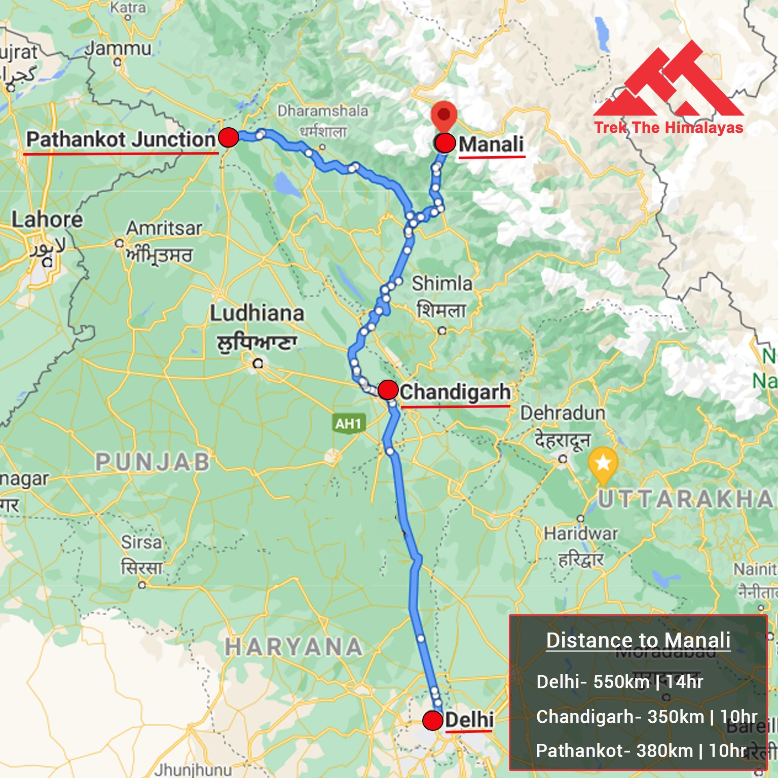
First, you can arrive at Chandigarh, Delhi, Pathankot, or Bhuntar airport. The journey from these locations to Manali is explained below.
1. Take an overnight bus to Manali from Delhi or Chandigarh, taking a bus from Chandigarh is the most ideal option.
- Chandigarh to Manali Bus: 10 hours.
- Delhi to Manali Bus: 14 hours is hectic and takes more time.
( We always recommend going for the govt. Buses over the private ones outside the bus station as based on the experience we have found that there are very high chances of delay involved with private buses. Also, govt. Buses are always more reliable. Whichever bus you choose, just make sure to reach Manali at 10 am. )
2. You can take a flight to Bhuntar Airport (but we would not recommend it because of the high prices of the flight and very high chances of cancellations), Manali is just a couple of hours away and you can easily get a bus or a private taxi till there. If you do plan to come via Bhuntar, make sure to reach at least a day before the trek starts.
3. You can even come via train, Chandigarh railway station is from where you can get direct buses to Kullu/Kasol/Manali that is 275 km from there and would take an overnight journey. Even in this case, reach a day before at Manali.
( If you prefer to travel independently, you can either take a government bus or book a private cab. Your trek coordinator will provide guidance on how to arrange for the bus or cab booking.)
Drop-Off Information
- The designated drop-off point is the Manali Gov bus stand around 6:30 pm to 7:30 pm .
- Please consider planning your subsequent travel arrangements after 8:00 pm.
- It's highly advisable to keep a buffer day in your travel plan. If the buffer day is not needed, it can be used to explore Manali.
- TTH offers comfortable transportation through Tempo Traveler, Bolero, or equivalent vehicles. If you wish to upgrade your mode of transportation, please contact your trek coordinator for further assistance.
Cost Terms
Inclusion
1. Accommodation (as per the itinerary):
- Camping on Day 1 to Day 4.
2. Meals (Veg + Egg):
- From the Day 1st Lunch to the Day 5th Breakfast.
3. Support:
- 1 Versatile base camp manager: handles communication and deploys extra manpower in emergencies.
- 1 Mountaineering & First aid qualified professional trek Leader.
- 1 Experienced high-altitude chef.
- Local experienced guides (Number of guides depending on the group size).
- Enough support staff.
4. Trek equipment:
- Sleeping bag, Sleeping liners (if required), mattresses, and Utensils.
- 3 men all season trekker tent (twin sharing), Kitchen & Dining tent, Toilet tent.
- Camping stool, Walkie talkie.
- Ropes, Helmet, Ice axe, Harness, Gaiters & crampons (if required).
5. First aid:
- Medical kit, Stretcher, Oxygen cylinder, Blood pressure monitor, Oximeter, Stethoscope.
6. Transportation (as per the itinerary):
- Manali to Jobra.
- Chatru to Manali with Chandratal.
7. Mules/porters to carry the central luggage.
8.Cloakroom facility available at the base camp for additional luggage.
9. All necessary permits and entry fees, Upto the amount charged for Indian.
10.Services from Manali to Manali.
11. Trek Completion Certificate
Exclusion
1. Insurance (Mandatory).
2. Food during the transit.
3. Any kind of personal expenses.
4. Mule or porter to carry personal luggage.
5. Emergency evacuation, hospitalization charge, etc.
6. Anything not specifically mentioned under the head Inclusion.
Things can be provided on demand and availability (participant has to pay extra for these things).
1- Satellite phone/set phone - is a type of mobile phone that connects via radio links via satellites orbiting the Earth instead of terrestrial cell sites like cellphones. Therefore, they can operate in most geographic locations on the Earth's surface.
2- Gamow/PAC HAPO Bag (Portable Hyperbaric Bag) - is a unique, portable hyperbaric chamber for the treatment of acute mountain sickness (AMS), also known as altitude sickness.
3- AEDs (Automated External Defibrillators) - are portable life-saving devices designed to treat people experiencing sudden cardiac arrest, a medical condition in which the heart stops beating suddenly and unexpectedly.
Cancellation Terms
To request a cancellation, please email us at info@trekthehimalayas.com using your registered email ID.
Cancellations prior to 25 days from the start of the Trip
Refund Options
- 5% deduction of trek fee
- 100% cash voucher for any trip till one year
- Transfer your trek (any trek, any date) to your friend
Cancellation between 24 days and 15 days to the start of the Trip
Refund Options
- 30% deduction of trek fee
- 100% cash voucher for same trip till one year
- 85% cash voucher for any trip till one year
- Transfer your trek (same trek, any date) to your friend
Cancellation between 14 days and 10 days to the start of the Trip
Refund Options
- 50% deduction of trek fee
- 80% cash voucher for same trip till one year
- 70% cash voucher for any trip till one year
- Book the same trek, in the same season, with any other batch
- Transfer your trek (same trek, any date) to your friend
Cancellation less than 9 days to the start of the trek.
Refund Options
- No cash refund
- 20% cash voucher for the same trip till one year
- 10% cash voucher for any trip till one year
- Transfer your trek (same trek, same date) to your friend
Cancellation Policy (Emergency Cases):
In case of a death in the immediate family (parents, siblings, spouse, children) or if the trekker is hospitalized (min. 48 hours) or suffers a fracture (leg/arm) within a week before the trek, even if canceled a day before:
90% refund in cash
10% as a voucher (valid for 1 year, for any India trek)
Valid documents required. We’re here to support you during tough times.
Note- If a booking is made using a voucher or discount code, the policies related to vouchers and discounts cannot be modified.
In the unlikely event that TTH cancels a trek prior to the scheduled departure date:
While it is extremely rare for TTH to cancel a trek, we understand that unforeseen circumstances or natural disasters may occasionally require us to do so before the scheduled departure. These circumstances could include continuous rain or snow, thunderstorms, snowstorms, landslides, floods, earthquakes, or any other natural calamity that poses a risk to the safety of our trekkers. Additionally, unforeseeable events such as local riots, curfews, pandemics, lockdowns, government orders, or any similar situations that compromise the safety of the trekking experience may also necessitate a cancellation.
In the event of such a cancellation, TTH will provide you with a voucher equivalent to the amount you paid for the trek. This voucher can be redeemed for any of our treks within the next year, allowing you to still enjoy an adventure with us at a later date.
Note
-
The issuance of a voucher is not applicable in situations where you are required to descend from the trek for any reason. The trek leader may make the decision to send you down from the trek due to factors such as insufficient fitness level, symptoms of Acute Mountain Sickness (AMS), high blood pressure, exceeding the designated turn-around-time, health concerns, or if you are found smoking, drinking, or violating the rules set for the trek. In such cases, the provision of a voucher does not apply.
In the Rare Event that TTH Shifts a Trek
We would like to emphasize that weather conditions in high-altitude areas are highly unpredictable and can undergo sudden changes at any time, irrespective of the day. Additionally, circumstances beyond our control, such as natural disasters, political unrest, pandemics, and lockdowns, may impact the feasibility of conducting a trek. In cases where we are unable to proceed with an event due to such circumstances that are beyond our direct control, we will make every effort to provide you with an alternative trek that is safer and more suitable.
In such situations, we will issue a voucher to offset the cost difference between the originally scheduled trek and the alternative trek. This voucher can be redeemed at any time within one year from the date of issue. Please note that a refund fee or reimbursement of the cost difference is not applicable in these cases.
Note:
- Change of trek batch is dependent on the availability of seats in the batch
- In case of transferring a trek to a friend, he/she should satisfy all the mandatory requirements put forward by TTH
- TTH holds the right to change/cancel the policies, without prior notice
- Cash refund is applicable only in case of bookings made without using any promotional offer code or vouchers
Cash Voucher Terms
- This is a non-transferable voucher
- The voucher cannot be merged with any other offer of Trek The Himalayas
- The voucher is valid for Trek booked directly with Trek The Himalayas in India
- To avail the voucher please use your register phone number or e-mail id
- All the other Terms of booking a trek with Trek The Himalayas are applicable to the voucher
- Trek The Himalayas holds rights to add/remove any of the Terms and Conditions without prior notice
Itineraries are based on information available at the time of planning and are subject to change. "Trek The Himalayas" reserves the right to change expedition dates, people or itineraries as conditions warrant. If a trip must be delayed or the itinerary changed due to bad weather, road conditions, transportation delays, government intervention, airline schedules, sickness, or other contingency for which TTH or its agents cannot make provision, the cost of delays and/or other changes are the responsibility of the participant. TTH reserves the right to decline, or accept, any individual as a trip member for any reason whatsoever.
Trek Essentials
Rent EquipmentPDF Of Trek Essential Download
| Backpack with rain cover | (50 - 60 ltr) with comfortable shoulder straps |
| Day pack with rain cover | 20 - 30 ltr (If off-load opted) |
| Walking stick | Advisable (At least one) |
| Water Bottle / Hydration pack | 2 bottles of one liter each, People who use hydration pack 1 hydration pack and 1 bottle of one liter. |
| Small size tiffin/lunch box | 1 Nos |
| Snacks | Energy bars, dry fruits, electral/ors |
| Personal Medical Kit | Consult your doctor |
| T-Shirt (Synthetic quick dry) | 2 Full & 2 Half sleeves |
| Fleece T-shirt | 1 Nos |
| Wind stopper / Fleece jacket | 1 Nos |
| Windproof Jacket | 1 Nos |
| Down feather / Hollow jacket | 1 Nos |
| Thermal inner (Upper and Lower) | 1 Pair |
| Trek Pant (Synthetic quick dry) | 3 Nos |
| Wind stopper / Fleece Pant | Not required |
| Waterproof gloves | Not required |
| Fleece / woollen gloves | 1 Pair |
| Poncho / waterproof Jacket and pant | 1 Nos |
| Sunscreen | 1 Nos |
| Moisturiser | 1 Nos |
| Chap-stick / Lip balm | 1 Nos |
| Toothbrush and toothpaste | 1 Nos |
| Toilet paper & Wipes | 1 Nos |
| Soap / hand sanitizers | 1 Nos |
| Antibacterial powder | 1 Nos |
| Quick dry towel | 1 Nos |
| Head torch | 1 Nos. (Avoid Hand torch) |
| Sun Cap | Not required |
| Woolen cap | 1 Nos. |
| Balaclava | Not required |
| Buff / Neck-gaiters | 2 Synthetic |
| Sunglasses | UV with dark side cover, People who wear spectacles - (A)- Use contact lenses | (B)- Photo chromatic glasses |
| Trekking shoes | 1 Pair (Waterproof, high ankle, good grip) |
| Floaters / flip-flops | 1 Pair |
| Cotton socks | 7 pairs |
| Woollen socks | 1 pairs |
| Gaiters | 1 Pair (TTH provides when required) |
| Micro spikes | 1 Pair (TTH provides when required) |

Frequently Asked Questions(FAQ)
To register with TTH, visit our website - www.trekthehimalayas.com and create your account. To create your account you will need to use your email address and fill in all the details, set your unique password and your account is ready to use.
- To book a trek with TTH, you first need to register with us and create an account.
- Choose the trek that you want to do and click on available dates.
- You will land at the login page, fill in the required details.
- Add Participants, choose add-on services click on the Pay now button, choose your preferred payment method, and make the payment. TTH accepts multiple payment options, including credit/debit cards, net banking, and UPI.
- You will receive a confirmation email from TTH with all the necessary details about the trek, including the meeting point, transportation, accommodation, and other important instructions.
- Click Here to watch Video
please send an email to us at info@trekthehimalayas.com or reach out to the numbers provided in the Help and Support section of your Trek Page. We will ensure that your issue is promptly resolved.
To book services such as off-load luggage and transportation, you can find them listed as add-ons. These additional services can be booked at the time of your initial booking. If you miss booking add-ons during the initial reservation, you can log in anytime and easily book 4 days before the departure date add-ons through the platform.
If you have booked the wrong trek or selected the wrong date, don’t worry! You can contact us at +91 9368882322 (Monday to Saturday, 10 AM to 10 PM) or email us at info@trekthehimalayas.com. You can also discuss this with your trek coordinator. Please make sure to inform us at least 10 days before the departure of your trek. Only then can we help you reschedule or arrange another trek for you.
We recommend visiting our "Suggest Me a Trek" page. By filling out the form, our experts will contact you with the best possible trek options based on your preferences and experience level. Alternatively, you can reach out to us via email at info@trekthehimalayas.com or give us a call using the numbers provided on our website for personalized assistance and recommendations.
Family treks differ from regular treks by focusing on ease of difficulty, offering shorter durations for younger participants, Kid-friendly and easily digestible foods, child-friendly activities, maintaining a higher guide ratio for diverse age groups, and implementing additional safety measures for families.
Family Trek with Kids recommendation Only Dayara Bugyal and Chopta Chandrashila Trek.
Minimum age for TTH treks is typically 7 years, though this may vary depending on the specific trek.
Yes, you can take a kids to a high-altitude trek with a parent. Discuss with a trek expert before booking a trek.
- Junior trekkers (below 15 years) should have a company of parents/guardians.
- Trekkers between 15 to 18 years can come solo with the disclaimer form signed by parent/guardian.
- Medical & Disclaimer Form (Mandatory Documents) Click here to download medical and disclaimer form
Physical Fitness: Ensure your child is physically fit. Engage them in regular exercise, outdoor activities, and hikes to build stamina and endurance. Hydration: Emphasize the importance of staying hydrated at high altitudes. Encourage your child to drink water regularly, even if they don't feel thirsty. Proper Nutrition: Provide a well-balanced diet with sufficient carbohydrates for energy and foods rich in iron to prevent altitude sickness. Adequate Sleep: Ensure your child gets enough sleep in the days leading up to the trek. Quality rest is crucial for altitude adaptation. Educate on Altitude Sickness: Teach your child about the symptoms of altitude sickness, such as headache, nausea, and dizziness. Encourage them to communicate any discomfort immediately. Appropriate Clothing and Gear: Dress your child in layers to adjust to changing temperatures. Ensure they have appropriate trekking gear, including sturdy footwear. Positive Mindset: Foster a positive mindset. Encourage your child, and let them know it's okay to take breaks when needed. Medical Check-Up: Schedule a medical check-up before the trek to ensure your child is fit for high-altitude activities. Consult with a healthcare professional about any potential health concerns.
TTH takes special care to provide wholesome and nutritious food for children on treks. Here are some of the foods that are typically served for children:
Breakfast: For breakfast, TTH serves a variety of options like porridge, cornflakes, bread, butter, jam, honey, boiled eggs, omelettes, and pancakes. Children can choose from these options to fuel themselves for the day's trek.
Lunch: For lunch, TTH serves lunch which includes rotis, vegetables, rice, dal, and salad. The rotis are usually made fresh on the trek and are a good source of carbohydrates. The dal and vegetables provide protein and other essential nutrients.
Snacks: TTH provides healthy snacks like fresh fruits, dry fruits, energy bars, cookies, and biscuits to keep the children energized throughout the day.
Dinner: For dinner, TTH serves a hot and wholesome meal which includes soup, rice, dal, vegetables, and a non-vegetarian dish (if requested in advance). Children can also choose from a variety of desserts like custard, jelly, and fruit salad.
Dietary requirements: If a child has any special dietary requirements, TTH can cater to those needs as well. For example, if a child is lactose intolerant or allergic to nuts, the kitchen staff can make arrangements to accommodate those requirements.
Choosing the right trek for a beginner can be a bit overwhelming as there are many factors to consider such as distance, elevation gain, terrain difficulty, weather, and time of year. Here are some tips that can help you choose the right trek for a beginner:
1. Determine fitness level: Assess the fitness level of the beginner to understand their physical capabilities. This will help you select a trek that is challenging but not too difficult.
2. Choose a well-traveled trail: A well-traveled trail will have more amenities such as signposts, water stations, and shelter. It is also safer as there will be other hikers on the trail.
3. Consider the length of the trek: For beginners, it is recommended to start with a shorter trek that can be completed in a day or two. This will help them get acclimatized to trekking and build their confidence.
4. Look for gradual elevation gain: Choose a trek with a gradual elevation gain rather than steep ascents. This will make the trek easier and more enjoyable.
5. Check the weather: Check the weather forecast before selecting a trek. Avoid treks during the monsoon season or winter when the trails can be slippery or dangerous.
6. Research the trail: Read about the trail to get an idea of the terrain, altitude, and difficulty level. This will help you select a trek that is suitable for the beginner.
7. Consult with an expert: If you are unsure about which trek to choose, consult our trek expert Mr. Nitin (+91 70600 59773) between 10 AM to 6 PM (Tuesday - Friday). Mr. Nitin will provide you valuable advice and guidance.
Overall, it is important to choose a trek that is enjoyable, challenging but not too difficult, and suitable for the beginner's fitness level and experience.
It is not recommended for a beginner to choose a difficult Himalayan trek. Trekking in the Himalayas can be physically and mentally challenging, especially if you are not used to the high altitude, steep slopes, and rugged terrain. Choosing a difficult trek without the proper experience, fitness level, and preparation can be dangerous and put you at risk of altitude sickness, injury, and other hazards.
If you are a beginner, it is recommended to start with an easier trek and gradually build up your skills and experience. This will help you understand the challenges of trekking in the Himalayas, and also prepare you physically and mentally for a more difficult trek in the future. It is also important to choose a trek that matches your fitness level, experience, and interest.
There is no specific age limit for a beginner trekker. However, it is important to consider your physical fitness, health condition, and personal interests before embarking on a trek. Trekking in the Himalayas can be physically and mentally demanding, and requires a certain level of physical fitness and endurance.
If you have any pre-existing medical conditions or are above a certain age, it is recommended to consult with a doctor before embarking on a trek. It is also important to listen to your body and take breaks as needed during the trek to prevent exhaustion or injury.
We recommend visiting our "Suggest Me a Trek" page. By filling out the form, our experts will contact you with the best possible trek options based on your preferences and experience level. Alternatively, you can reach out to us via email at info@trekthehimalayas.com or give us a call using the numbers provided on our website for personalized assistance and recommendations.
Yes, you can join the trek. We have fixed departure groups where you can simply book your trek and we will take care of curating a group.
Before you start the trek, it is recommended that you make all the necessary phone calls as during the trek you may or may not receive network coverage, once you come back to the Base Camp, you can reconnect with your family via phone once again. You can share your trek coordinator contact detail with your family members to get the latest updates about your trek batch.
At TTH, we provide wholesome and nutritious meals during the trek. The food is vegetarian and includes a variety of dishes such as rice, dal, vegetables, chapati, paratha, pasta, noodles, and soup. We also offer snacks such as biscuits, and salty, and dry fruits during the trek. Special dietary requirements such as vegan, gluten-free, or Jain food can also be arranged if informed in advance.
If you are allergic to some foods, you need to let us know in advance so that we can make arrangements accordingly.
TTH is a trekking company that prioritizes the safety of all its participants, including women trekkers. We have a comprehensive safety system in place, which includes a dedicated team of experienced and trained trek leaders and support staff who are equipped to handle emergency situations and provide first aid.
TTH also takes specific measures to ensure the safety and comfort of women trekkers. They have a separate tent accommodation for women trekkers, female trek leaders, and support staff. They also provide separate toilet facilities for women and encourage a safe and respectful environment for all trekkers.
Moreover, TTH has a strict policy against any kind of harassment and has a zero-tolerance policy towards such incidents. They have a designated Internal Complaints Committee (ICC) to investigate and address any complaints related to harassment or misconduct. Overall, TTH has a good reputation for safety and responsible trekking practices, and women can feel comfortable and safe while trekking with them.
In case you are the only women in the group, we provide a single sleeping arrangement. Also, during the trek, the trek leader will always remain by your side to provide optimum safety and reassurance.
You can reach out to the trek coordinator to inquire about the number of female trekkers and their respective states who have booked the trek. Please note that the trek coordinator cannot disclose personal details of any trekker. Once you've confirmed your booking, a WhatsApp Group will be created for all the trekkers in your batch. This allows you to connect with fellow trekkers before the trek begins.
While many of our treks are led by female trek leaders, however, it is not possible to know which trek leader is assigned to which group. But nonetheless, whether the trek leader is male or female you can be completely assured of your safety and security with us.
Yes, it is possible to trek with periods. However, it is important to take some extra precautions and preparations to ensure a comfortable and safe trekking experience. Here are some tips that can help you trek during your period:
1. Use menstrual hygiene products that you are comfortable with, such as tampons, pads, or menstrual cups. It is recommended to carry enough supplies for the entire duration of the trek.
2. Pack wet wipes, hand sanitizer, and plastic bags to dispose of used hygiene products.
3. Wear comfortable and breathable clothing that allows for easy movement and reduces friction. Avoid wearing tight or restrictive clothing that can cause discomfort.
4. Carry pain relief medication, such as ibuprofen or acetaminophen, in case of menstrual cramps.
5. Stay hydrated and maintain a balanced diet to support your energy levels and overall health.
6. Take breaks as needed and listen to your body. If you feel uncomfortable or experience any unusual symptoms, seek medical attention immediately. It is also recommended to consult with a doctor before going on a trek during your period, especially if you have a pre-existing medical condition or are taking medication.
By taking necessary precautions and being prepared, you can have a safe and comfortable trekking experience even during your period. We provide proper disposal facilities for sanitary pad disposal during the trek.
We offer three person tents with twin-sharing for optimum comfort. A woman trekker will share a tent with another woman trekker and if you are the only woman in the group, you will be given a single accommodation for your comfort and privacy.
Yes, we do provide gears on rent. You can book it using you TTH account directly.
Mountaineering qualified Experienced and first aid certified Trek Leader, First Aid Certify local guide, Cook, helpers and supporting staff.
People suffering from Bronchitis, Asthma, High blood pressure, Epilepsy (got faints), TB , Heart problem or on higher BMI side are strictly not allowed to go on any Himalayan trek. Apart from this if you had any medical history, please let us know.
No. Alcohol and smoking isn’t allowed while on trek. It is totally misconception that it will keep you warm. Your body need to acclimatize properly and for that eat properly and drink enough water; these things will keep you warm.
Toilet tents provide a convenient solution for answering nature's call in the great outdoors. Dry toilets, in particular, offer a highly sanitary approach. By digging a pit and utilizing mud and a shovel, you can easily cover up your waste. This method ensures cleanliness and hygiene while camping or exploring in the forest.
Remember to pack essential toiletries to complete your outdoor bathroom kit and maintain proper personal hygiene during your adventures. With these practices in place, you can enjoy nature while also respecting it.
Layer Up From Head To Toe
Eat Full Meals, never sleep empty stomach
You can keep warmee (if you’re more susceptible to cold).
Use sleeping bag in right way and don’t leave free space in sleeping bag.
For upper body
– Thermal layer
– T-shirt (full-sleeves)
– Fleece T-shirt (for extreme colds)
– Fleece layer
– Thick Jacket/Down Jacket
– Waterproof or Windproof layer (outermost layer, when it is snowing or raining)
- For Lower Body
– Thermal layer
– Hiking pants (normal) or Winter hiking pants
Based on how warm you feel you can skip any of the above layers. Your outer later should be windproof since it is windy at high altitude.
The idea behind layering is that the more insulation you have the less cold you feel, and instead of wearing a very thick jacket if you wear multiple layers, your body will be better insulated against the cold.
Yes, we provide micro spikes and gaiters, if required.
Mandatory documents: 2 xerox of ID having address (addhar card/driving license), 2 Passport size photographs, hard copy Medical form signed & sealed by doctor, disclaimer form sign by trekker and high altitude insurance.
No. We don’t but we can suggest you good hotel/Stay nearby pick up location.
Yes, trekker must carry 2 water bottles 1 litre each so they can refill it at campsite for drinking and keep themselves hydrate.
You should buy shoes which has these three features –Good grip, Ankle Support and additional water resistant layers. Generally, we advise Quechua Trek 100, MH 500 and MH 100.
No one is forced to go on. There is always enough staff to split the party according to need and regroup later at the camp. Most people have no trouble reaching the highest campsite. If some members decide not to climb the final distance they can wait for the climbers to come back down the same way or take a lateral path to the descent route.
Trek The Himalayas is the safest and most trusted trekking organization in India. Our deep expertise and commitment ensure that each trekker can fully immerse in the Himalayan beauty while experiencing a well-organized and memorable journey. We are proud to be recognized among the best trekking companies in India and have been awarded the PHD Samman Award two years consecutively for Best Adventure Tour Operator. Our founders, themselves are proficient mountaineers and belong to the hilly states of India. At TTH we follow all the safety protocols. Our Trek Leaders are expertly trained in First Aid and Acute Mountain Sickness (AMS) management. The extensive experience is a key factor in establishing us as the best trekking company in India.
Explore the best trekking companies in India and see what sets them apart.Yes, Trek The Himalayas (TTH) provides customized trekking packages, and premium trek packages, apart from fixed departures tailored to your preferences and needs. We understand that each trekker has unique interests, timeframes, and fitness levels, so we are happy to design a customized trek package that aligns with your goals. If you are seeking a specific experience, such as camping under the stars, a photography-focused trek, or an itinerary that includes cultural and heritage sites, our team can help create the ideal trekking package for you.
With a customized trek, you have the flexibility to choose aspects like trek difficulty, duration, group size, and even special add-ons like guided tours of nearby villages or extended camping nights at scenic locations.
Our customization options are ideal for families, groups, corporate teams, and solo adventurers looking for a tailored journey through the Himalayas.
Yes, you need special permits for Trekking in India, especially in protected or restricted areas. In states like Uttarakhand, Himachal Pradesh, and Ladakh, trekkers may need to obtain permits from local authorities or forest departments before starting their journey. For international trekkers, special permits like the Inner Line Permit (ILP) are required for regions such as Ladakh and Arunachal Pradesh. To make the process easier, Trek The Himalayas assist adventurers in obtaining all the necessary paperwork and permits, ensuring a hassle-free trekking experience.
Trek The Himalayas is committed to promoting Sustainable Tourism and Eco-Friendly Tourism by following responsible trekking practices and encouraging our trekkers to do the same.
We have introduced impactful initiatives like Heal Himalaya and Leave No Trace. Through these programs, we regularly organize cleaning drives along trekking routes and surrounding areas to keep the trails free from litter. Our team carries trash bags during every trek, ensuring that all waste collected from the slopes is brought back to the base and disposed of properly. We also take active steps to reduce plastic waste by completely avoiding the use of single-use plastics and encouraging our trekkers to do the same. Small changes like carrying reusable bottles and eco-friendly alternatives can make a big difference in protecting the environment.
By choosing to trek with us, you become a part of this movement toward responsible and sustainable trekking.
Yes, Trek the Himalayas provides trekking tours to well-known pilgrimage sites, including Kailash Mansarovar Yatra, Adi Kailash Yatra, Char Dham Yatra, and Panch Kedar.
Trekking in India offers something for everyone, from easy trails for beginners to tough and challenging routes. If you're planning to go for high-altitude or difficult treks like Kang Yatse or Pin Parvati, it's better to have some prior trekking experience.
However, if you're new to trekking, there are many beautiful and beginner-friendly options to start with, like Dayara Bugyal, Ali Bedni, Chandrakhani Pass, Sandakphu, Surya Top, and many others. Your preparation depends on the trek you choose. Easier treks need basic fitness, while tougher ones require more training and experience.
India offers a wide range of beautiful treks, and the best one really depends on your fitness level, experience, and what kind of views or adventure you’re looking for. Here are some of the most popular and well-loved treks:
Sandakphu Trek, Sikkim/West Bengal – Famous for views of four of the five highest peaks in the world.
Dayara Bugyal Trek, Uttarakhand – A perfect choice for beginners with scenic meadows and easy trails.
Ali Bedni Bugyal Trek, Uttarakhand – Known for its lush meadows and close views of Mount Trishul and Nanda Ghunti.
Pin Bhaba Pass Trek, Himachal Pradesh – A stunning crossover trek with changing landscapes.
Kashmir Great Lakes Trek, Jammu and Kashmir – One of the most beautiful treks in India, with alpine lakes and valleys.
Ranthankharak Trek, Uttarakhand – A less-crowded trail offering peace and beautiful mountain views.
Valley of Flowers Trek, Uttarakhand – A UNESCO World Heritage Site, famous for its vibrant blooms during monsoon.
Choose the one that matches your fitness and interest, and you’re in for an unforgettable experience.
Deciding which Indian state has the "best" trekking is tough, as it really depends on what you're looking for. However, Himachal Pradesh and Uttarakhand consistently stand out as top contenders, both offering incredible variety and stunning Himalayan scenery.
Himachal Pradesh is a trekker's paradise, boasting the Dhauladhar, Pir Panjal, Shivalik, and Zanskar ranges. Uttarakhand, often called the "Land of Gods," also has an abundance of beautiful trails. Its Garhwal and Kumaon regions feature iconic treks through lush alpine meadows that turn into snowy landscapes in winter.
Apart from Himachal and Uttarakhand Sikkim (with views of Kanchenjunga) and parts of Jammu & Kashmir (like the Kashmir Great Lakes trek) also offer unique and exceptional experiences. Ultimately, the "best" state depends on your preference for lush valleys, spiritual paths, or remote mountain adventures.
For beginners, one of the best trekking options is the Nag Tibba trek in Uttarakhand. It’s an easy to moderate trek, perfect for first-timers. The trail offers beautiful mountain views, takes just a couple of days, and gives a good idea of what trekking in the Himalayas feels like.
Other beginner-friendly treks that are slightly longer but still manageable include Kedarkantha, Bhrigu Lake, Kuari Pass, and Dayara Bugyal. These treks are not very tough and give you more time in the mountains, with amazing scenery and a great learning experience.
To start trekking in India, follow these simple steps:
1. Choose an easy trek: Pick a beginner-friendly trek that matches your fitness level. Go for shorter and well-marked routes that don’t have very steep climbs or high altitudes. Treks like Chopta–Chandrashila, Nag Tibba, or Dayara Bugyal are great options to begin with.
2. Work on your fitness: Start getting fit a few weeks before your trek. Focus on building stamina by walking daily, especially on stairs or slopes. Jogging, cycling, or light exercises to strengthen your legs and core will also help you enjoy the trek better.
3. Get the right gear: Invest in a few good essentials, comfortable trekking shoes, a light but strong backpack, and layered clothing that works for changing mountain weather. Don’t forget basics like a water bottle, headlamp, and trekking poles for better comfort and safety on the trail.
With the right planning and preparation, trekking can be a fun and unforgettable experience!
The “most beautiful trek in India” can vary from person to person, but some treks are widely known for their scenic views. Valley of Flowers, Hampta Pass, Pin Bhaba Pass, and Kashmir Great Lakes are often considered the most scenic treks in the country.
These treks have some of the best landscapes, snow-covered mountains, lush green meadows, crystal-clear rivers, and in some places, vibrant wildflowers spread across the valley. The mix of colors, natural beauty, and peaceful surroundings make these treks a visual treat for every nature lover.
The Hampta Pass trek is considered a moderate difficulty trek. It is not too easy, but not extremely hard either. Most people with average fitness can do it with some preparation. The trail includes a mix of easy walks and a few tricky sections, especially while crossing the pass itself. Since it is a high-altitude trek, you may feel breathless or tired quickly, so proper acclimatization and a steady pace are important. Overall, with the right mindset, physical readiness, and guidance, the Hampta Pass trek is a beautiful and manageable adventure for many trekkers.
The Hampta Pass trek takes around 5 days to complete. During these 5 days, you will walk through beautiful landscapes like green valleys, rocky paths, and snowy mountains. Each day covers a certain distance, giving you enough time to rest and enjoy the views. The trek is planned in a way that helps you adjust to the altitude slowly. Though the journey is short, it is filled with adventure, changing scenery, and memorable experiences. With good planning and a positive spirit, 5 days are enough to fully enjoy the beauty of the Hampta Pass trek.
The best time to do the Hampta Pass trek is between June and September. During these months, the weather is mostly clear, and the trails are open and safe. In June and July, you can see snow at the higher parts of the trek, which makes the journey more exciting. August and September offer green valleys, blooming flowers, and beautiful mountain views after the monsoon rains. These months are perfect for enjoying the natural beauty and having a comfortable trekking experience. So, if you're planning the Hampta Pass trek, June to September is the ideal time to go.
The Hampta Pass trek route starts from Manali and takes you through some of the most stunning landscapes in Himachal Pradesh. On the first day, you drive from Manali to Jobra and then begin a short trek to Chika, where you camp for the night. The next day, you trek from Chika to Balu Ka Ghera, walking through green meadows and streams. On the third day, the trail becomes a bit more challenging as you cross the Hampta Pass and reach Shea Goru, surrounded by snow and rocky paths. On the fourth day, you trek down to Chatru and then take a drive to the beautiful Chandratal Lake, if the road and weather allow. Finally, on the fifth day, you drive back from Chatru to Manali, ending your journey.
The Hampta Pass Trek is located in Himachal Pradesh. This trek connects the lush green Kullu Valley to the dry and barren Lahaul Valley, creating a dramatic change in landscape. You start the trek near Manali, in the Kullu region, and slowly make your way across the pass into the stunning and remote areas of Lahaul. The route gives you a chance to see two very different sides of the Himalayas in one trek.
The Hampta Pass Trek Package includes all essential facilities to ensure a smooth and comfortable experience. A comfortable accommodation and all meals are provided, including tea, soup, and snacks. The package also includes a professional trek leader, experienced local guides, a skilled high-altitude chef, and sufficient support staff. High-quality trek equipment like tents, sleeping bags, and essential safety gear is provided.
Medical assistance is available with a first aid kit, oxygen cylinder, and other necessary equipment. Transportation for the entire trek route, including pick-up and drop-off, is included. Additionally, mules or porters carry central luggage, a cloakroom facility is available for extra baggage, and all necessary permits and entry fees are covered. A trek completion certificate is also provided.
The Hampta Pass trek covers a total distance of around 24 kilometers. This distance is spread out over 5 days, so each day you walk a few kilometers at a steady and comfortable pace. Even though 24 km may not sound like a lot, the changing weather and high altitude can make the trek feel slightly challenging. With good planning and regular breaks, most people can complete this distance and fully enjoy the beauty of the Hampta Pass journey.
The height of Hampta Pass is 4,300 m / 14,100 ft, which is also the highest point during the Hampta Pass Trek.
Yes, someone above 60 years of age can do the Hampta Pass trek, but they need to be physically fit and well-prepared. If the person has done trekking recently and is used to walking in the mountains, it will definitely help. However, even without recent trekking experience, they can still do the trek if they have good stamina and strength.
To check their fitness level, they should be able to jog 5 kilometers in around 33 minutes without feeling too tired, or walk 10 kilometers in about 75 minutes without stress. If they prefer cycling, they should be able to cycle 15 kilometers in 45 minutes comfortably. The Hampta Pass trek involves walking at high altitude, so it’s important to prepare the body through regular walking, jogging, or cycling before the trek. With the right preparation, age is not a barrier, and anyone who is determined and fit can enjoy this beautiful journey.
No, you will not get mobile network coverage during the Hampta Pass trek. The last place where you’ll find a proper signal is in Manali. Once you begin the journey and move towards the mountains, there won’t be any mobile network. It’s a good idea to inform your family and friends before starting the trek and enjoy a peaceful, disconnected experience in nature.
No, there is no electricity available at the campsites on the Hampta Pass trek. Since you’ll be staying in remote mountain areas, it’s best to carry fully charged power banks to keep your phone or camera running. Try to save battery by keeping your devices on airplane mode when not in use.
For the Hampta Pass trek, you need to wear strong, high-ankle trekking shoes that have good grip and are waterproof. These shoes will help you walk safely on rocky, slippery, or snowy paths. Also, carry a pair of lightweight sandals to wear while you cross the rivers and stay at the campsite.
The risk of altitude sickness during the Hampta Pass trek is moderate. The highest point you’ll reach is around 14,100 feet (4,300 meters), which is not extremely high but can still cause some people to feel unwell. To stay safe, it’s important to acclimatize properly, walk slowly, stay hydrated, and listen to your body. If you feel dizzy, tired, or breathless, it’s best to rest and inform your trek leader. It’s always a good idea to check with a doctor before going on any high-altitude trek.
Yes, offloading services are available on the Hampta Pass trek. This means you can hire a mule or porter to carry your backpack, so you can trek more comfortably. If you feel your bag is too heavy or you want to enjoy the trek without carrying much weight, offloading is a helpful option.
During the Hampta Pass trek, you will stay in tents at the campsites. These tents are usually shared by two people and are set up at different spots along the route. Though basic, the tents provide a comfortable and safe place to sleep in the middle of nature. You’ll also be given sleeping bags and mats to keep warm during cold nights.
Yes, June is a great time to do the Hampta Pass trek. During this month, the weather is mostly pleasant, and the trail is full of beautiful views. There is still some snow on the higher parts, but not too much, which makes it easier and more fun to walk. You also get to see and walk on snow bridges, which adds to the adventure. The mix of green valleys and white snow makes June a perfect time to enjoy the beauty of the mountains.
Yes, June is a great time to do the Hampta Pass trek. During this month, the weather is mostly pleasant, and the trail is full of beautiful views. There is still snow on the higher parts, but not too much, which makes it easier and more fun to walk. You also get to see and walk on snow bridges, which adds to the adventure. The mix of green valleys and white snow makes June a perfect time to enjoy the beauty of the mountains.
Here are some other treks in Himachal you can consider:
Sar Pass Buran Ghati Chandrakhani Pass Bhrigu Lake Rupin Pass
Each trek offers beautiful views, unique trails, and a great adventure in the mountains.
Yes, the Hampta Pass trek is a monsoon trek.
Yes, you can usually find snow on the Hampta Pass trek during June and early July. However, the presence and amount of snow depend largely on the weather conditions of that particular year. In some seasons, snow may linger longer, while in others, it might melt earlier. Always check recent weather and trail updates before planning your trek.
Explore Most Informative Articles on Hampta Pass Trek
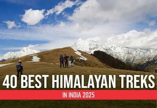
40 Best Himalayan Treks in India 2025
Discover the 40 Best Himalayan Treks in India for 2025 with Trek The Himalayas! The Himalayas, stretching across India’s northern frontier, offer a diverse range of trekking adventures for all skill levels. From the iconic Everest Base Camp to the serene Valley of Flowers, each trek reveals unique landscapes, diverse flora, and vibrant local cultures. Whether you're seeking challenging climbs, scenic hikes, or rich cultural experiences, the Indian Himalayas provide something for every adventurer. Explore these top treks to embrace breathtaking views, traverse ancient trails, and embark on unforgettable journeys in one of the world's most majestic mountain ranges. Prepare for an extraordinary trekking experience that will leave you in awe of the Himalayas’ natural beauty and cultural ric...
Discover the 40 Best Himalayan Treks in India for 2025 with Trek The Himalayas! The Himalayas, stretching across India’s northern frontier, offer a diverse range of trekking adventures for all skill levels. From the iconic Everest Base Camp to the serene Valley of Flowers, each trek reveals uniqu...
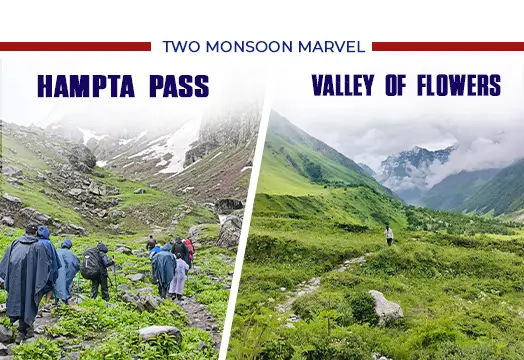
Two Monsoon Marvels – Valley of Flowers & Hampta Pass Trek
Experience the magic of the monsoon season with Trek The Himalayas on two incredible treks: the Valley of Flowers and Hampta Pass. As the distant rumble of thunder echoes through the valleys and the first raindrops gently fall, the Himalayas undergo a stunning transformation into a lush, vibrant world. The Valley of Flowers becomes a breathtaking tapestry of colorful blooms set against a backdrop of misty mountains, offering an enchanting and serene trekking experience. Meanwhile, the Hampta Pass Trek takes you through diverse landscapes, from verdant meadows to stark, dramatic high-altitude terrain, all enhanced by the monsoon's rejuvenating touch. Both treks reveal the Himalayas’ true splendor during this season, showcasing the region's dynamic beauty and the refreshing allure of its ...
Experience the magic of the monsoon season with Trek The Himalayas on two incredible treks: the Valley of Flowers and Hampta Pass. As the distant rumble of thunder echoes through the valleys and the first raindrops gently fall, the Himalayas undergo a stunning transformation into a lush, vibrant ...
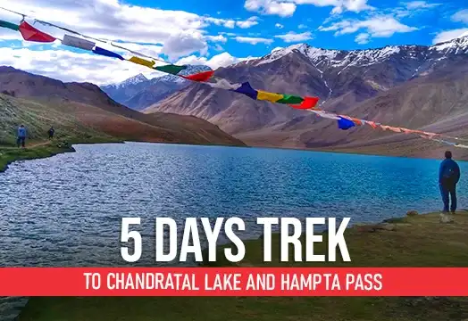
5 days trek to Chandratal lake and Hampta pass
Looking for an all-in-one trek package? Consider the Hampta Pass Trek with Trek The Himalayas! This Himalayan adventure offers easy access and a blend of stunning landscapes, including pine forests, open meadows, and breathtaking glacial valleys. Starting from Manali, this 5-6 day trek ascends up to 14,100 feet and covers approximately 26 km. You'll traverse diverse terrains, from lush Kullu Valley to the barren Lahaul Valley, with highlights such as the picturesque Chandratal Lake. Ideal for bird enthusiasts, the area is home to nearly 300 species. The trek's contrast of green and rocky landscapes, combined with the crossing of Rohtang Pass, promises an unforgettable journey. Embrace nature's beauty and thrilling experiences on this remarkable trek, perfectly suited for adventurers see...
Looking for an all-in-one trek package? Consider the Hampta Pass Trek with Trek The Himalayas! This Himalayan adventure offers easy access and a blend of stunning landscapes, including pine forests, open meadows, and breathtaking glacial valleys. Starting from Manali, this 5-6 day trek ascends up...
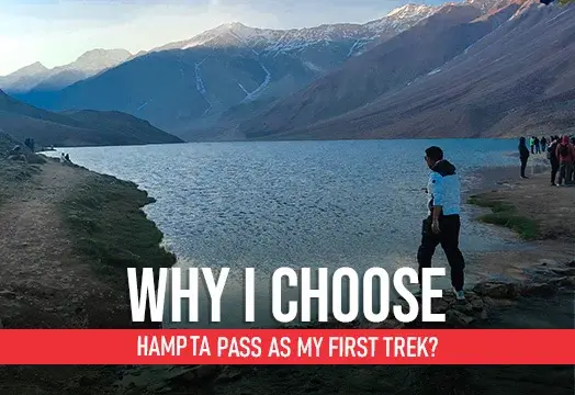
Why Choose Hampta Pass as a First Trek ?
Choosing Hampta Pass as my first trek was a perfect decision, combining stunning landscapes, diverse terrain, and a manageable level of challenge for beginners. Trek The Himalayas made this journey an unforgettable introduction to trekking. The trail offers a captivating transition from lush green valleys to stark, barren landscapes, showcasing the incredible diversity of the region. The manageable altitude gain and well-marked paths made it ideal for novice trekkers like me, offering just the right amount of adventure without feeling overwhelming. The breathtaking views of snow-capped peaks and the serene beauty of Chandratal Lake were highlights of the trek. With the supportive team and experienced guides from Trek The Himalayas, I felt safe and confident throughout the journey. Hampt...
Choosing Hampta Pass as my first trek was a perfect decision, combining stunning landscapes, diverse terrain, and a manageable level of challenge for beginners. Trek The Himalayas made this journey an unforgettable introduction to trekking. The trail offers a captivating transition from lush gree...
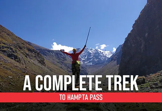
Hampta Pass Trek 2025 - Himachal Pradesh Treks
Trekking should blend fun, adventure, and unforgettable moments. With this mindset, I chose Hampta Pass for my latest adventure. The trek, known for its doughty challenges, stunning landscapes, and diverse terrains, promised rewards that matched the effort. My friends' tales of Hampta Pass fueled my excitement, and I was eager to experience it myself. The trek, starting from Manali, took us through picturesque Prini village and the majestic Pir Panjal range. The contrast between the lush greenery of Kullu and the barren stony landscapes of Lahaul, combined with awe-inspiring views of Mt. Deo Tibba and Mt. Indrasan, made the trek unforgettable. A visit to the moon-like Chandratal lake was a highlight. Hampta Pass exceeded all my expectations, proving to be an adventurous and fulfilling e...
Trekking should blend fun, adventure, and unforgettable moments. With this mindset, I chose Hampta Pass for my latest adventure. The trek, known for its doughty challenges, stunning landscapes, and diverse terrains, promised rewards that matched the effort. My friends' tales of Hampta Pass fueled...
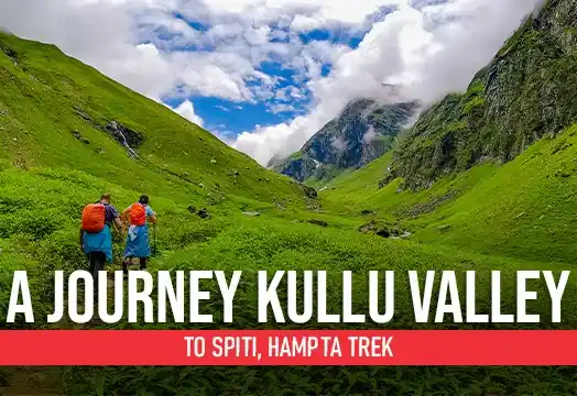
A Journey Kullu Valley to Spiti, Hampta Trek
Embark on the scenic Hampta Trek with Trek The Himalayas, journeying from the lush Kullu Valley to the arid landscapes of Spiti. This trek offers a unique experience of diverse landscapes, starting with the verdant meadows and dense pine forests of Kullu, gradually transitioning to the stark, barren beauty of Spiti's high-altitude desert. Along the way, you'll encounter stunning mountain vistas, crystal-clear rivers, and vibrant wildflowers. The highlight of the trek is crossing the Hampta Pass, a challenging yet rewarding experience offering panoramic views of the surrounding peaks. As you descend into the Spiti Valley, you'll witness the dramatic change in scenery, from lush greenery to rugged, moon-like terrain. The Hampta Trek is perfect for adventure enthusiasts and nature lovers s...
Embark on the scenic Hampta Trek with Trek The Himalayas, journeying from the lush Kullu Valley to the arid landscapes of Spiti. This trek offers a unique experience of diverse landscapes, starting with the verdant meadows and dense pine forests of Kullu, gradually transitioning to the stark, bar...
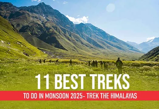
11 Best Treks to do in Monsoon 2025 - Trek The Himalayas
Experience the magic of India's top monsoon treks with Trek The Himalayas. As the rains transform the landscape into a vibrant tapestry of lush greenery, our treks take you through some of the most breathtaking trails in the country. Wander through mist-covered forests, cross streams swollen with fresh rain, and marvel at cascading waterfalls that come alive during the monsoon. From the Valley of Flowers in Uttarakhand to the Hampta Pass in Himachal Pradesh, each trek offers a unique blend of adventure and natural beauty. The mist-laden mountains, blooming wildflowers, and serene lakes create a picturesque setting that captivates the soul. Whether you're an experienced trekker or a nature lover seeking a refreshing escape, our monsoon treks promise an unforgettable experience. Join Trek...
Experience the magic of India's top monsoon treks with Trek The Himalayas. As the rains transform the landscape into a vibrant tapestry of lush greenery, our treks take you through some of the most breathtaking trails in the country. Wander through mist-covered forests, cross streams swollen with...
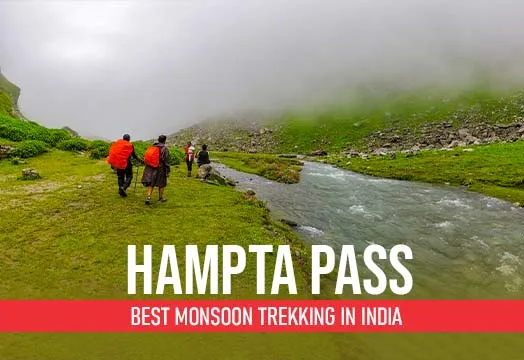
Hampta Pass Trek: Best Monsoon Trekking in India
Experience the thrill of a cross-over monsoon adventure with Trek The Himalayas on the Hampta Pass Trek. This exciting journey takes you through rugged terrains and lush landscapes, offering a unique blend of adventure and natural beauty. As you trek through dense forests, alpine meadows, and high-altitude passes, you'll witness the dramatic contrasts of the region, where verdant valleys meet stark, barren landscapes. The monsoon adds a touch of magic to the trek, with rain-kissed greenery and mist-covered mountains enhancing the scenery. Whether you're navigating challenging trails or soaking in the serene surroundings, the Hampta Pass Trek provides an unforgettable adventure. Join us to explore this captivating route and experience the raw beauty of the Himalayas during the monsoon se...
Experience the thrill of a cross-over monsoon adventure with Trek The Himalayas on the Hampta Pass Trek. This exciting journey takes you through rugged terrains and lush landscapes, offering a unique blend of adventure and natural beauty. As you trek through dense forests, alpine meadows, and hig...
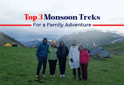
Top 3 Monsoon Treks for a Family Adventure
Discover the perfect family adventure with Trek The Himalayas’ Top 3 Monsoon Treks. These carefully selected treks offer the ideal blend of excitement and safety, making them perfect for adventurers of all ages. Immerse your family in the lush beauty of the monsoon season, where vibrant landscapes and mist-covered trails create an enchanting experience. From gentle paths through dense forests to serene riversides and breathtaking mountain views, these treks allow you to connect with nature while creating lasting memories together. Enjoy quality time with your loved ones as you explore these picturesque trails, guided by our experienced team who ensure a safe and enjoyable journey for everyone. Trek The Himalayas is dedicated to providing unforgettable family trekking experiences that fo...
Discover the perfect family adventure with Trek The Himalayas’ Top 3 Monsoon Treks. These carefully selected treks offer the ideal blend of excitement and safety, making them perfect for adventurers of all ages. Immerse your family in the lush beauty of the monsoon season, where vibrant landscape...
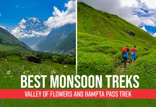
Valley of Flowers and Hampta Pass Trek - Best Monsoon Treks
Unveil the magic of the monsoon with Trek The Himalayas by exploring two of India’s most enchanting treks: the Valley of Flowers and Hampta Pass. Embark on a breathtaking adventure through the Valley of Flowers, where vibrant, rare blooms create a stunning floral tapestry against the backdrop of towering peaks. Experience the lush meadows and diverse wildlife as you traverse this UNESCO World Heritage site. Then, conquer the thrilling Hampta Pass, a trek that takes you through diverse landscapes, from lush green valleys to rugged high-altitude terrain. The pass offers panoramic views of the majestic Himalayas and an exhilarating crossing that adds an element of adventure. Together, these treks showcase the diverse beauty of the monsoon season, providing a perfect blend of serenity and c...
Unveil the magic of the monsoon with Trek The Himalayas by exploring two of India’s most enchanting treks: the Valley of Flowers and Hampta Pass. Embark on a breathtaking adventure through the Valley of Flowers, where vibrant, rare blooms create a stunning floral tapestry against the backdrop of ...
Best Monsoon Treks in Himalayas
Discover the best monsoon treks in the Himalayas with Trek The Himalayas. Explore our top picks for treks that come alive during the rainy season, offering lush landscapes and stunning scenic beauty amidst the rain-soaked mountains. As the monsoon breathes new life into the Himalayas, you’ll find trails adorned with vibrant greenery, cascading waterfalls, and mist-covered peaks. Our curated selection of treks includes routes that showcase the diverse splendor of the region while ensuring a safe and enjoyable experience. Whether you seek the tranquility of verdant meadows, the thrill of river crossings, or the beauty of hidden valleys, these treks promise an unforgettable adventure. Join us to explore the Himalayas in their monsoon glory and immerse yourself in the serene and exhilaratin...
Discover the best monsoon treks in the Himalayas with Trek The Himalayas. Explore our top picks for treks that come alive during the rainy season, offering lush landscapes and stunning scenic beauty amidst the rain-soaked mountains. As the monsoon breathes new life into the Himalayas, you’ll find...
.webp)
Hampta Pass - A Remarkable Himalayan Experience
Experience the beauty of the Himalayas with Trek The Himalayas on the Hampta Pass trek—a remarkable journey through stunning landscapes. This trek offers an exceptional adventure, crossing from the lush green valleys of Kullu to the stark, arid terrains of Lahaul. As you navigate through diverse landscapes, you'll be captivated by the contrasting sceneries: verdant meadows, alpine forests, and rugged mountain ridges. The trek provides panoramic views of towering peaks, including the majestic Indrasen and Deo Tibba. You'll also traverse picturesque villages and serene lakes, including the charming Chandra Tal. Our experienced guides ensure your safety and enhance your experience with local insights and support. Join us to explore the Hampta Pass and immerse yourself in the breathtaking b...
Experience the beauty of the Himalayas with Trek The Himalayas on the Hampta Pass trek—a remarkable journey through stunning landscapes. This trek offers an exceptional adventure, crossing from the lush green valleys of Kullu to the stark, arid terrains of Lahaul. As you navigate through diverse ...
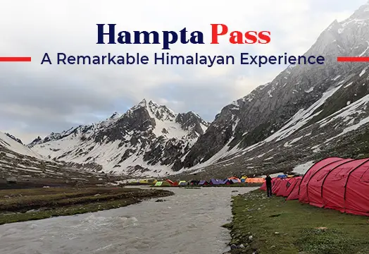
Trekking In India and The Himalayas
India, with its dense Himalayan ranges, stands out as a premier destination for trekking enthusiasts. The Himalayas offer a plethora of trekking options for adventure seekers, including some of the most breathtaking trails in the country. Explore the Valley of Flowers, famous for its vibrant meadows, or challenge yourself with the high-altitude Stok Kangri. Roopkund's mysterious lake and the serene Har Ki Dun valley provide unique experiences, while the Hampta Pass offers diverse landscapes in a single trek. The Brahamatal trek promises stunning snow-capped views, and the Tarsar Marsar trek reveals pristine alpine lakes. Even during the monsoon season, when many might think Himalayan treks are off-limits, there are still plenty of options for incredible hikes. Join Trek The Himalayas to...
India, with its dense Himalayan ranges, stands out as a premier destination for trekking enthusiasts. The Himalayas offer a plethora of trekking options for adventure seekers, including some of the most breathtaking trails in the country. Explore the Valley of Flowers, famous for its vibrant mead...
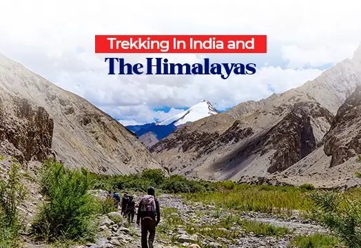


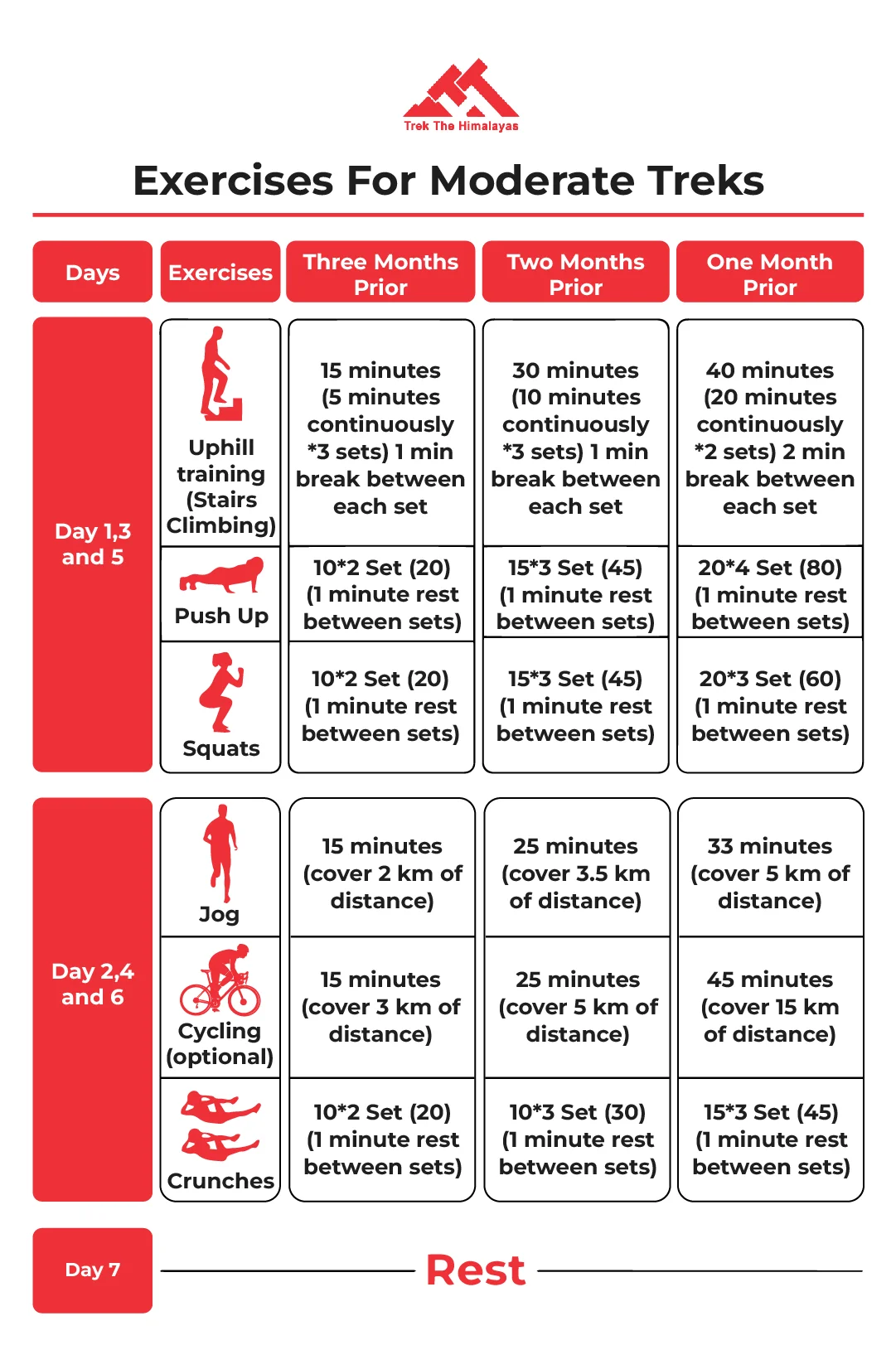