Index
- Day 1: New Jalpaiguri to Jaubhari (Altitude of 6,400 ft)
- Day 2: Jaubhari to Tumling (Altitude of 9,450 ft)
- Day 3: Tumling to Kalipokhri (Altitude of 10,400 ft)
- Day 4: Kalipokhri to Sandakphu peak (Altitude of 11,950 ft)
- Day 5: Sandakphu to Sabargram (Altitude of 11,807 ft)
- Day 6: Sabargram to Gorkhey via Phalut (Altitude of 7546ft)
- Day 7: Gorkhey to Sepi (Altitude of 6,234 ft)
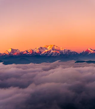
After doing several hikes in the Sahyadri range in Maharashtra, I decided to start hiking the Himalayan Mountains. After searching for a few treks in the Himalayan range, I decided to submit to the Sandakphu which is the highest peak in West Bengal at an altitude of 11,950 feet from sea level. The best part about choosing Sandakphu Trek is that one can see the summit point of Mt. Kanchenjunga (The Sleeping Buddha range), Mt. Everest, Mt. Lhotse and Mt. Makalu from the Sandakphu peak.

Day 1: New Jalpaiguri to Jaubhari (Altitude of 6,400 ft)
The journey started from New Jalpaiguri Railway Station, from where the pickup was arranged for Jaubhari which was our base camp for this trek. We, 6 guys, took accommodation in Siliguri so we started our journey from Siliguri instead of New Jalpaiguri Railway Station. The journey from Siliguri to Jaubhari was amazing with a beautiful view of Pine forest on our way. Jabari is located at an altitude of 6,400 ft. As we moved ahead on our way, the climate started getting colder and colder. Our cab stopped at Mirik which is a popular tourist place and famous for its Mirik lake. The lake is surrounded by huge Pine trees which is a very good place for photographers. We spent almost an hour at Mirik lake with the spicy taste of Momos. After our Mirik lake visit, we stopped at one restaurant for lunch where the remaining trek team was already present. We introduced ourselves to each other and left for Jaubhari after our lunch. We stopped in between at the place from where we had a beautiful view of Kanchenjunga. Nearly at 5:00 PM, we all reached our base camp at Jaubhari. Our trek leader Sushant introduced us to the whole trek plan along with some instructions for the trek during our Soup session. After dinner, we all get into our rooms with the huge excitement of the next day’s trekking.
Day 2: Jaubhari to Tumling (Altitude of 9,450 ft)
We started our journey at 8:30 in the morning. Before starting the trek, Sushant introduced us to two local guides from Jaubhari who were going to be with us during the whole trek. Mr Buddhaji and Mr Gopalji. Mr Buddhaji always led us from the front and Mr Gopalji from the back.

It was about 3 km of ascending through the forest. It took us about 2 hours to reach Chittrey, which was our tea point. Just beside our tea point, there was a small monastery with a Buddhist flag. From Chitty we continued our trek towards Meghma(Mother of clouds) which was our Lunch point. Chittrey to Meghma is about a 6 km distance including ascending through forest and the motor road. Before reaching Meghma we registered our names in the SSB camp near Meghma. It is always important to register ourselves in the SSB camp as we were walking on the International border of India and Nepal. Nearly at 2:30 PM we all got done with the lunch and continued to trek towards Tumling which was our campsite and 2 km from Meghma. Meghan to Tumling was flat walks ascend on the motor road. This motor road was not as flat as we trekkers had imagined. The road had so many rocks in between. It looked simple but was very difficult to climb. After 1.5 hours of walking, we reached our Second camp i.e. Tumling which is on the Nepal side. Tumling is located at an altitude of 9450 ft. We had a beautiful view of Kanchenjunga from the Tumling campsite.

After some stretching lessons from Nilesh and Narita, we had our Soup session where Sushant instructed us on the next day’s itinerary. We played a few group games before our Dinner. We ended our day with little chit-chats and better hope for the next day’s trekking.
Day 3: Tumling to Kalipokhri (Altitude of 10,400 ft)
We started our trek at 8:30 in the morning. After walking a few distances we officially entered the Singalila National Park. It majorly descended 5 km through the beautiful bamboo forest trail, some meadows and some motor road walk to the Gairibas SSB camp. Gairibas was our tea point where we had the spicy taste of Momos. The whole descent has so many beautiful views to enjoy on our way, especially the bamboo forest trail. After Gairibas we had 2 km of steep ascend which took us to Kaiyakatta which was our lunch point. This ascend was quite difficult as it was a fully steep climb. At some points, we faced the cloud. The weather was cool which didn’t let us feel sweaty and tired. At around 12:30 PM, we reached Kaiyakatta for our lunch. After lunch, it was a 4 km of level walk through the motor road. We were instructed by our lead Sushant to be quiet on our way as we could spot the Red Panda. Singalila National Park is a famous place for spotting Red Pandas. As it was too cloudy weather so there was no chance to spot Red Panda for us. Hard Luck!! On our way, we met a few Army Jawans who were refilling their water canes.

We had a very good conversation with Jawans. In return, they offered us tea in their camp. We were thankful about it but we refused tea as we wanted to stick with our trek group. By 4:30 PM, we reached our campsite at Kalipokhri.

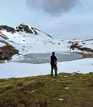
In Nepal, Kala means Black and Pokhri means Lake. This village has a black lake which is surrounded by waving Buddhist prayer flags. That is why it is known as Kalipokhri. Kalipokhri is located at an altitude of 10,400 ft. After some stretching exercises from Nilesh, we went for our Soup session. Sushant instructed us on the next day’s itinerary along with some good information about a few Himalayan mountains during our Soup session. Rohit, one of our trek members, also shared some useful information about mountains. After some group games and dinner, we headed to our bed.
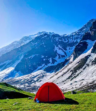
Day 4: Kalipokhri to Sandakphu peak (Altitude of 11,950 ft)

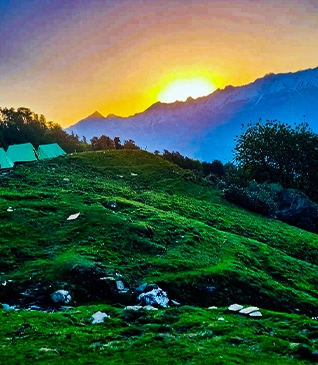
I had a beautiful sunrise view at 6 AM from our Kalipokhri campsite. Today was our summiting day for Sandakphu which is the highest peak in West Bengal at an altitude of 11,950 ft. Kalipokhri to Sandakphu is about 6.5 KMs of distance. We started our trek at 8:30 AM. The trail was a full ascent of 6.5 KMs including a zigzag climb on motor road. From our campsite at Kalipokhri only we could see Sandakphu peak. We took some rest at Bikheybhanjang for some time on our way to the trek. I and Mayur, one of our trek members, got a chance to take some photos of a small Nepali temple at Bikheybhanjang. Bikheybhanjang is also known as the Valley of Poison because of the poisonous aconite plant which grows here. After Bikheybhanjang the climb became slightly tough. We took a few shortcuts other than climbing through the motor road and which was quite challenging as well. We could see the Sandakphu peak throughout the trail. By 11:30 AM we reached the summit point of Sandakphu. It was an awesome feeling!! I took some tea and sat alone for a while to enjoy the achievement of summiting Sandakphu. After spending some time at Sandakphu peak we moved towards our campsite which was 1 KM away from Sandakphu peak. When we reached our campsite, we were all amazed at the beautiful view of Kanchenjunga. The Sleeping Buddha was looking amazing. On the left, we had the king of the mountains, Mt. Everest. The campsite was itself a beautiful place above the clouds.
We went to one hillock which was nearby to our campsite. We got lucky to have a clear and beautiful sunset view from there. During sunset, The Sleeping Buddha became golden by the sunlight. I was wishing to stay there for a long time even after sunset as I didn’t want to move my eyes from The Sleeping Buddha. But due to the extreme wind chill, it was not possible to stay long at that point. In our soup session, Buddha Ji sang one beautiful Nepali song. Neither of us understood the words of the song, but we felt the emotions behind that song. We also had some mountain ghost stories told by Sushant which made us all a little frightened for that night. After dinner I and my tent partners Mayur and Abhishek had a Retro singing session of Kishore Kumar’s songs. That was the most memorable part of this trek. The Sky was covered fully with shining stars. It was a beautiful star view, but due to the extreme level of wind chill, one cannot stand more than 5 minutes in the open. It was just for a couple of minutes I enjoyed the stars before the good night call.
Day 5 Sandakphu to Sabargram (Altitude of 11,807 ft):
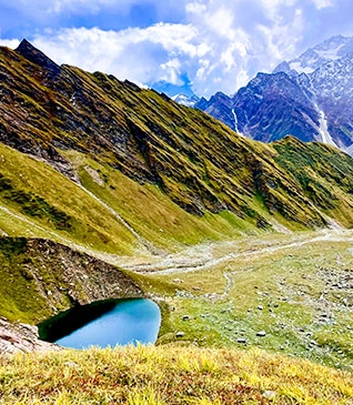
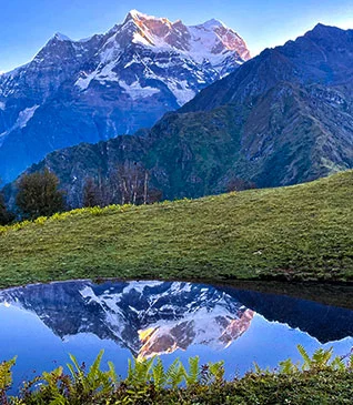
Sandakphu to Sabargam is 15 KMs of distance. We got a packed lunch in the morning before starting our trek. We started our trek at 8:30 in the morning. Initially, it was a motor road walk including small ascents and descents for the first 5 KM. Sleeping Buddha was playing hide-n-seek with us throughout this trail.

Sandakphu to Sabargram trail with beautiful Kanchenjunga


After the motor road trail, it was an awesome meadow walk including small ascends and descends. The meadow trail had some breathtaking views of Mt. Kanchenjunga and Mt. Everest. Though it was difficult to walk through the meadows due to the extreme wind chill, we all made it with full enthusiasm and the hiking spirit. After completing the meadow trail we took a halt at one place for our lunch. After lunch, it was a 3 km walk on the motor road to our campsite at Sabargram. The whole trail during our trek was sharing the International border of India and Nepal. And we all had huge excitement to walk on this kind of trail. We reached our campsite by 3:30 and as per our daily routine, we all had a stretching session. After walking for a long time in hiking it’s always better to do stretching because it will loosen the tight muscles and help muscles to keep relaxed and increase blood flow to nerves. After tea, 5-6 people went to the hillock nearby to our campsite to have the sunset view. The Sleeping Buddha becomes golden by the sunlight during sunset. After sunset, Buddha Ji explained to us some respectful information about Buddhism and a few places associated with it. And then it was time for some group games along with our dinner. And then we had a good night’s call.
Day 6 Sabargram to Gorkhey via Phalut (Altitude of 7546ft):
We enjoyed the beautiful sunrise from our campsite at Sabargram. As long as the sun was rising, slowly The Sleeping Buddha also started showing his beauty. Sabargram to Gorkhey is about 14 KMs, but if we go to Gorkhey via Phalut then it will be 21 KMs. The weather was clear so we got the call to reach our Gorkhey campsite via Phalut. So today was the longest day throughout our trek. We had to cover 21 KMs for today, so we started our trek early by 7:30 AM along with our packed lunch. Sabargram to Phalut was about 7 KMs. This trail includes a walk through the motor road and a meadow with small ascends and descends.

We saw one small water stream on our way which was completely frozen into ice from its upper side. Just like yesterday’s trial, Sleeping Buddha was playing hide-n-seek with us today as well. Just before reaching the Phalut, we had our tea halt at one trekker’s hut. From there Phalut peak was at just a 1 KM of distance.
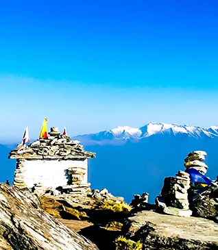
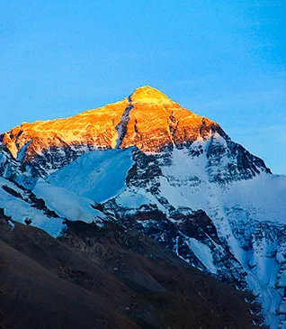
By 11 AM we reached the top of Phalut peak. And the view from Phalut peak was breathtaking. Phalut peak gave us the best view of The Sleeping Buddha during the whole Sandakphu trek. You can have the closest view of Sleeping Buddha. And just turn your head to the left, a little far but visible, Mt. Everest. Everyone was busy taking photographs. But I just wanted to enjoy the view. So I went to one of the cliffs nearby and sat down. There were some tears in my eyes of Happiness and the achievement of summiting Sandakphu and Phalut and having an amazing view of the world’s tallest mountains i.e. Mt. Kanchenjunga and Mt. Everest. After spending some time at Phalut peak we moved towards Gorkhey. Phalut to Gorkhey was about 15 KMs and the trail goes through the beautiful bamboo forest. The trail had a level walk with a steep descent before reaching the Gorkhey village.
Gorkhey village is surrounded by mountains and is located on the bank of the Gorkhey River. It was a very beautiful village we visited during our trek. A few people went to the Gorkhey river in the evening to have some fresh air. During our soup session, Sushant distributed the Trek Completion certificates and each trekker shared their experience on this trek. In the end, Mr Buddha Ji gave us a farewell speech. And the day ended with feelings of achievement.
Day 7 Gorkhey to Sepi (Altitude of 6,234 ft):
In the early morning, we 3 trekkers went to explore the Gorkhey village and we ended it by visiting the Pine forest area which is attached to the Gorkhey village. We started our trek by 7:30 in the morning. Gorkhey to Sepi is about 15 KMs. The trail was gradual and steep ascents through a forest from Gorkhey to Ramam. Ramam was our tea point which we all reached by 10:30. After Ramam, till Sepi it was a full-level walk descending through the forest. I enjoyed playing football with a few kids at one of the villages that came on our way. As it was the last part of the trek and that too with the beautiful descent, everyone was enjoying and excited to finish this trek. Just before Sepi, we crossed a hanging wooden bridge where lots of Buddhist prayer flags were fluttering in the wind.

After crossing the bridge it was a flat motor road walk for Sepi. The left side of the road is fully surrounded by mountains. I stop at one place and let the other trekkers move ahead and sit down at the mountainside edge of the road to enjoy the view and feel the peace. It was one of the best peaceful feelings I ever had. After spending some time at that place I joined the last group of trekkers to finish the trek. After just 15 minutes walk from there, we saw the restaurant which was our finishing point of the trek. I started running towards the restaurant just like I had participated in a race and was just about to win it. We all greeted each other for the successful completion of the trek. After giving goodbye wishes to each other, we all started moving towards our comfort zone, Home. 24 trekkers from all over India and other countries came together on this beautiful trek for 7 days and went with beautiful lifetime memories. What I learned during this trek is, how to push yourself beyond your limitations, and how to challenge yourself. In life, we all come across those hard situations where we almost think to give up. But all that matters is the Next Step. Your Next Step either will give you lifetime regret or it will fill you with beautiful lifetime memories. And we all know that Memories are always better than Regrets.
Upcoming Treks
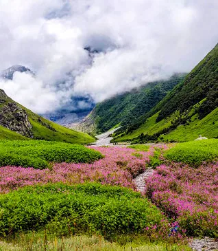
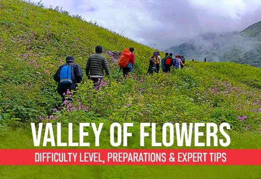
Valley of Flowers Trek
Uttarakhand
.webp)
Hampta Pass Trek
Himachal Pradesh
Pin Bhaba Pass Trek
Himachal Pradesh
Flat 10% Off
Markha Valley Trek
Ladakh
Bhrigu Lake Trek
Himachal Pradesh
Chandrakhani Pass Trek
Himachal Pradesh
Stargazing
Chopta Chandrashila Tungnath Trek with Deoriatal
Uttarakhand
Beas Kund Trek
Himachal Pradesh
.webp)
Gaumukh Tapovan Trek
Uttarakhand
.webp)
Rupin Pass Trek
Himachal Pradesh
Buran Ghati Trek
Himachal Pradesh
Panchkedar Trek & Drive
Uttarakhand
Everest Base Camp Trek
Kathmandu
Goechala Trek
Sikkim
.webp)
Annapurna Base Camp Trek
Pokhara
Stargazing
Sandakphu Trek
West Bengal

.webp)