.webp)
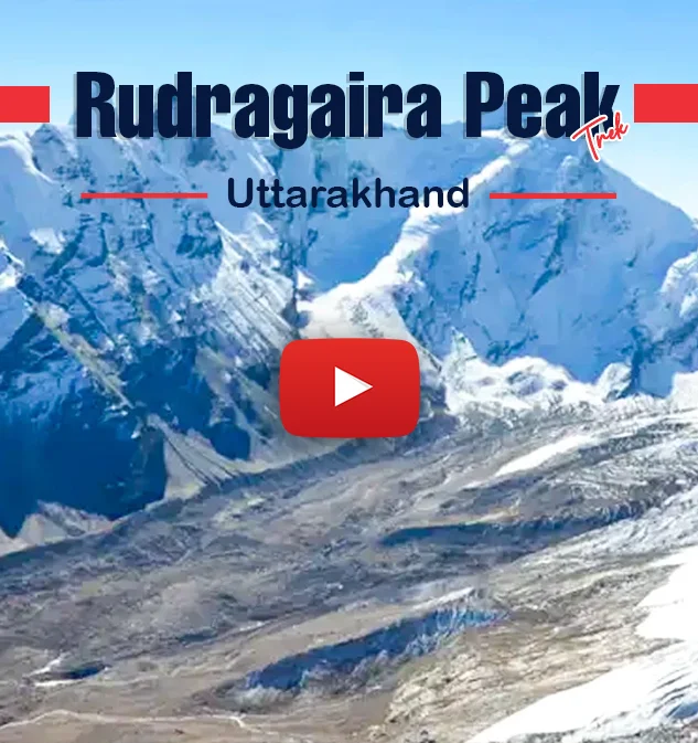
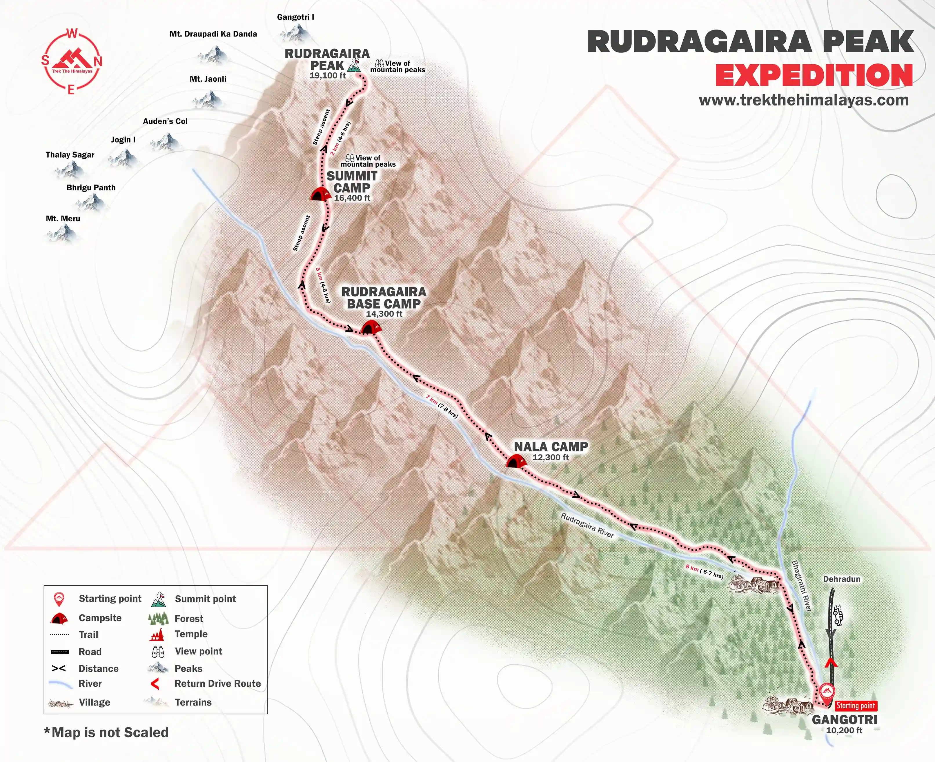
Rudragaira Peak Expedition
.webp)
Rudragaira Peak Expedition

Region
Uttarakhand | India

Duration
13 Days

Max Altitude
19086 Ft.

Trekking Km
50 KM

Grade
Challenging
Get in Touch with Our Trek Expert
91 8191004846 info@trekthehimalayas.comMonday - Saturday: 10 AM to 06 PM (GMT +5:30)
54000 /Person
- 5% GST will be applicable on Trek Cost and Add-ons
- Services Dehradun to Dehradun | Included Transport.
- Meeting Point( Pickup/ Drop Point ): Prince Chowk, Dehradun
- Reporting Time: 6:00 am
- Drop Time: 6:30 pm to 7:30 pm (Timings are subject to change based on weather and road conditions).
- Please reach Dehradun a day before to avoid any delays.
Get in Touch with Our Trek Expert
91 8191004846info@trekthehimalayas.com
Monday - Saturday: 10 AM to 06 PM (GMT +5:30)
Overview
Trek Name: Rudragaira Peak Expedition
Days: 13
Adventure Type: Mountaineering
Base Camp: Gangotri
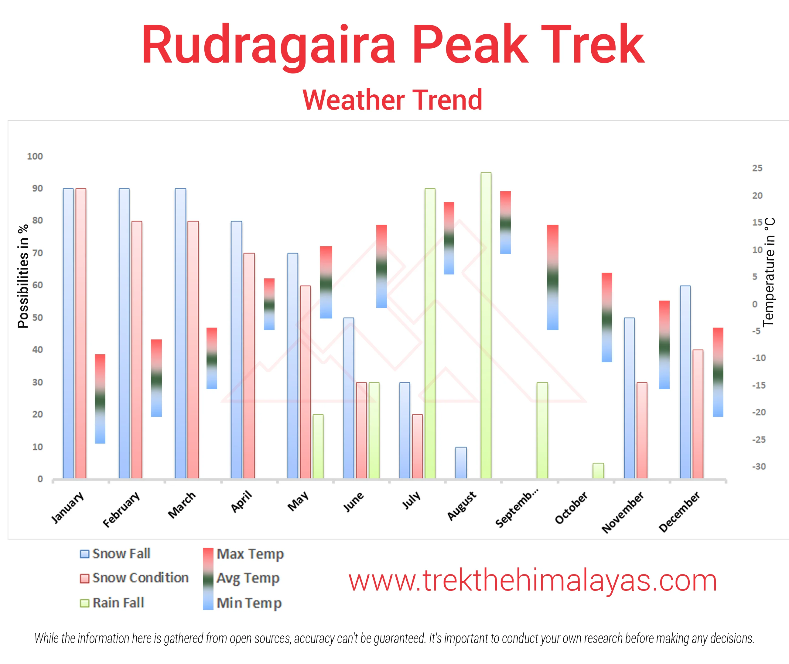
Season:Summer | Autumn |
Month:June |
Country: India
Altitude: 19086 Ft.
Grade: Challenging
Rail Head: Dehradun
Stay: Camping (Twin sharing) & Hotel/Guesthouse
Food: Meals while on trek & at Hotel/Guesthouse (Veg & Eggs)
Location: Uttarakhand
Distance: 50 Km.
Trail Type: Summit, Circle trail | Scale a peak, Camping in various locations, starting and ending at the same point.
AirPort: Jolly Grant Airport, which is 21 km away from Rishikesh
Highlights:
- 5% GST will be applicable on Trek Cost and Add-ons
- Services Dehradun to Dehradun | Included Transport.
- Meeting Point( Pickup/ Drop Point ): Prince Chowk, Dehradun
- Reporting Time: 6:00 am
- Drop Time: 6:30 pm to 7:30 pm (Timings are subject to change based on weather and road conditions).
- Please reach Dehradun a day before to avoid any delays.
Why is Rudragaira Peak a Must-Do Trek?
Mt. Rudugaira is located in the Rudu Valley of the Garhwal Himalayas. The Rudu Valley is known for its mesmerizing views of Gangotri peaks. It is also an entry point towards Gangotri massif and Audens Col.
Rudugaira Peak is considered a safe and easy peak. It is best for those who are starting in the Mountaineering field. Also, for trekkers who wish to raise their bar of climbing. With an easy approach, less height is a perfect mountain to gain experience.
The expedition starts from none other than the popular pilgrim destination Gangotri. From Gangotri, the trail slowly rises through dense forests, meadows, and the gushing Bhagirathi River.
The campsites are placed strategically on huge grasslands adorned by big mountains. The trail is such that it goes through variations every day. By the time you start the summit attempt, you have already crossed meadows, moraine, landslides, ridges, streams, etc.
This expedition introduces the concept of load ferry. In which the team shifts all the gear to the summit camp a day before and stats back at the base camp only. Therefore, it prepares one for big mountaineering expeditions. This method of load ferry is primarily for acclimatization.
The summit attempt is a walk through heaven. While it shows scary crevasses of Gangotri Peak but the sight of the first sun rays falling on the Gangotri massif is stupendous.
Who Can Participate
- Age Requirement:
- Minimum 18 years
- Experience of at least two high-altitude trek (4,500m- 5,000m) is required. First-timers are advised to avoid this trek.
- Fitness Criteria:
- Trekkers must be able to carry a 10-15 kg backpack, as off-load options are not recommended.
- If a trekker's BMI is more or less than the normal range (18-26), please consult our Trek Coordinator before booking.
Special Offer
Special Offer: Trek As Many Times as You Want!
At Trek The Himalayas, we understand that sometimes the unexpected happens, and you may not be able to complete your trek. Whether you are unable to finish the trek, or you’ve successfully completed it and want to experience it again, we have a special offer for you!
Make a single payment and trek the number of times you want.
Terms and Conditions:
- This offer is non-transferable.
- Valid only for Trek The Himalayas limited fixed departures.
- The offer is valid for 5 years from the trek departure date.
- The offer does not apply if the participant has received a cash refund or voucher at the time of cancellation or transferred the trek.
- Participants are not required to pay for the trek cost again but will need to cover transportation and trek permit costs.
- To reserve your spot, you can use our online booking form or simply give us a call. A deposit must be wired, including the initial payment, for confirmation.
- The offer will be activated once the participant reaches the trek base camp/meeting point.
- Trek The Himalayas reserves the right to revoke this offer without refund if a participant violates safety norms, trek rules, or code of conduct; is blacklisted for misconduct, false information, or payment issues; or damages TTH’s brand or reputation.
Rudragaira Peak Expedition Itinerary
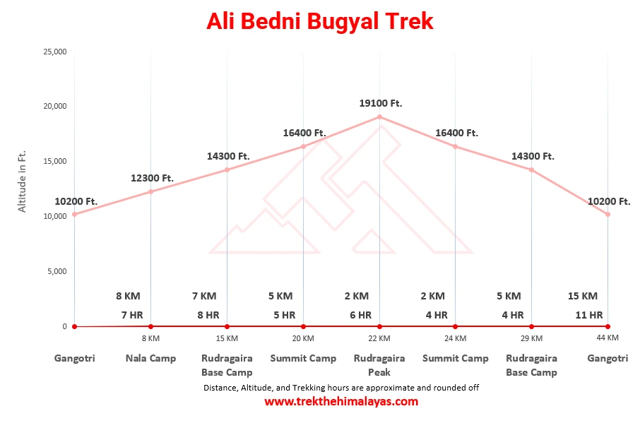
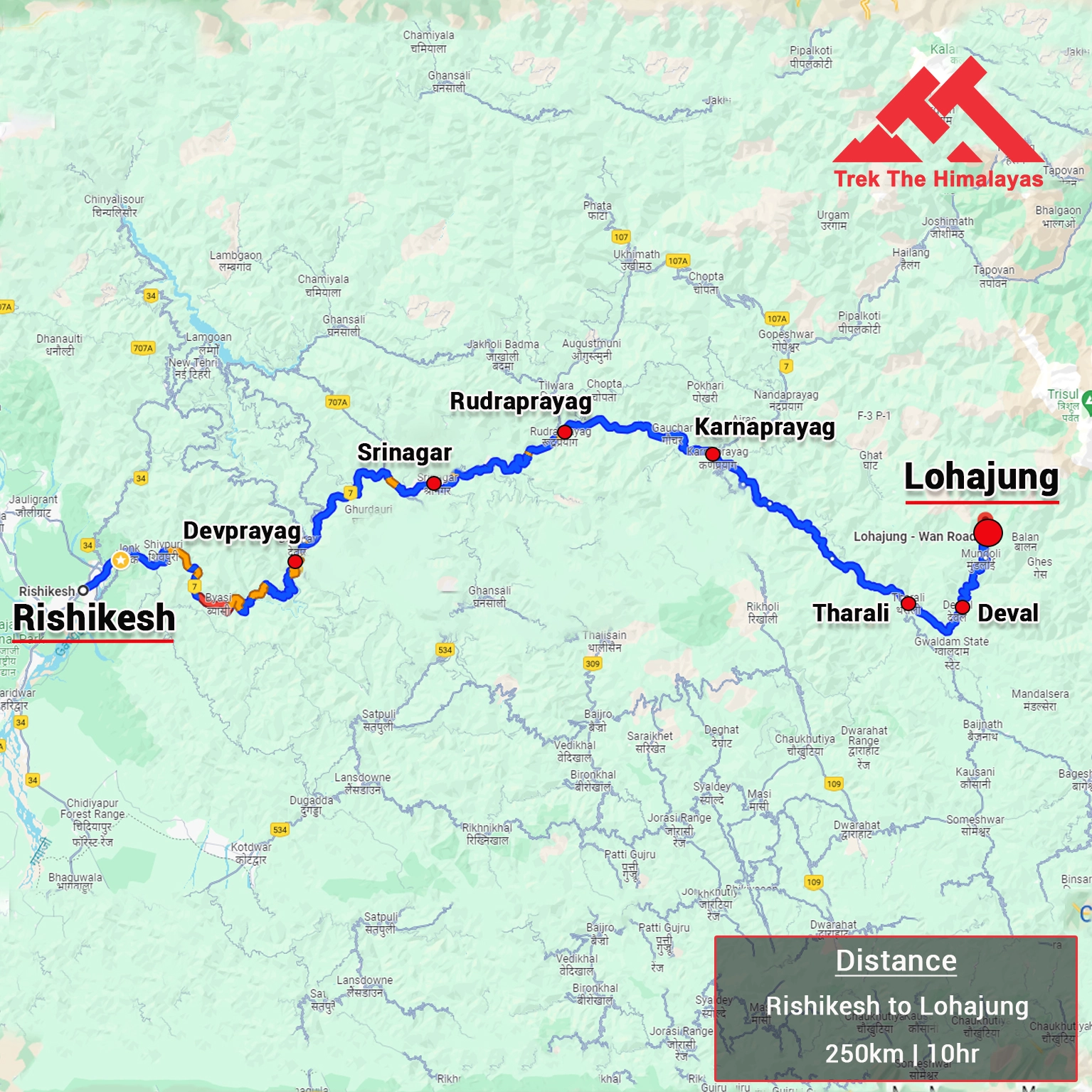
Dehradun to Gangotri
Get super excited to start your trek journey. The trek starts from Gangotri the most religious place in India. It is also one of the Char Dharmas. Before reaching here, you will pass Uttarkashi. Uttarkashi is located on river Bhagirathi and also hosts the NIM Mountaineering Institute. The drive is long and goes through twists and turns of the Himalayan roads passing through forests and many religious temples.
Gangotri is extremely crowded in March and April due to the Char Dhaam yatra. However, it is a beautiful place located on the banks of river Bhagirathi. Once you arrive here, take rest in your hotels. Save the exploration energy for the next day.
Rest and acclimatisation at Gangotri
Wake up in the lap of the religious hub. Today you can roam everywhere and fulfill your exploratory desires. Try to visit Surya Kund, Gauri Kund, Pandav Gufa, etc, all the temples around. Try to connect with the locals and pilgrims and other tourists. Make sure you do not strain your body because it is an acclimatization day and let your body adjust to the height.
Gangotri to Nala Camp
Get started towards Nala Camp for your exciting first trek day. The trail is long for 8-9 hours. You start by walking towards the valley. The trail is side by side Bhagirathi River. Keep walking for another 2 km until you come across a log bridge. Then take a right and enter Rudragaira Valley. This valley is of prime importance in Mountaineering as it shows Audens Col, Gangotri massif, etc. Enjoy the dense forest cover of Pine, Cedar trees around you. Enjoy the dense forest cover of Pine, Cedar trees around you.
The route now starts ascending. Be cautious while you cross the rockfall zone. You will come across the Bhoj Kharak campsite also. Observe that the more you climb up the forest cover becomes sparse. To your surprise you will then be welcomed by big grasslands blossomed with bright flowers. Yes, this amazing meadows is your stay for tonight. From the campsite first sight of Gangotri III and Jogin II can be seen.
Nala Camp to Rudragaira Base Camp
Today will be short compared to yesterday but will be strenuous. The entire route is uphill with a steep climb. Plus there will be enough stream crossing. There will not be any water sources on the way. Make sure you carry more than 2 litres of water. Just keep walking along the river in the valley. There are risky patches while passing the landslide area. Therefore, walk carefully.
After you get past that you may find a few snow patches. And the trail gets even steeper. Today you will see the first stunning sights of Rudragaira Peak, Jogin Peak, and Auden Col Pass. It will be exciting to see the summit. After a tiring day rest in your tents.
Rest and Acclimatization
After two wonderful days, it is now time to chill. Since you have gained the height of 14300 feet it is important to rest and get acclimatized. You can trudge nearby the campsite. Go for acclimatization walks. But try to remain out of the tents for the whole time. So, that your body will get used to the height.
Load ferry to Summit Camp and back
This day is reserved for load ferry, where the team shifts its gear and equipment to the summit camp and comes back for the night. This is the typical work high, sleep low technique of mountaineering. This helps with acclimatization for the summit attempt. You will be carrying packed lunch today.
Start by walking through meadows then move left towards moraines. Keep walking for 30 minutes and arrive arrives. Many use this a camp as high camp to reduce the summit camp distance.
The route henceforth is tough. It takes about 4 hours to reach the summit camp from here. The trail is blend of rocks and meadow type terrain. The path is also gradual climb. As you rise higher you rise up to the huge peaks of Gangotri, Sh, ikantha etc. These peaks come to visibility. You can also see the path leaAudenso Audens col.
Soon you will reach flat ground. That is the place of summit camp. The place is a stunning location with all the beauty of high peaks decored around. Load the gear in the camps and start descending to the Rudragaira base camp.
Rudragaira Camp to Summit Camp
Wake up early and get ready to climb the same route as yesterday. Today ybe staying at the summit camp following which will be the summit day.
Follow the exact same trail. Cross the moraines, meadows and rocky patches. Once you reach at the summit camp, re-check all your gear. The team will brief you about the summit attempt. Get full and sleep well. Finally the summit night comes.
Summit attempt and back to Summit Camp
The most awaited day starts quite early at 3-4 am. Get dressed in your gear for the summit push. Most of the climb is steep of 60 degrees inclined. First you cross moraine area and rocky patches. In fact throughout the route it will be rocky but there will enough h snow covered sections.
We start by moving towards left going to a ridge. This ridge will take you enough close to the summit. Even while walking try to look around. You can see the crevasse se area of Gangotri I peak. As the sun comes up, orangish-yellow hue behind the Gangotri form a mind-blowing sight. Something that will stay with you forever.
You may not know Rudragaira has 3 false summits. Hence, it is disappointing at times. There is a large hump which gives a feeling of being arrived at the summit. Another important thing of this peak is that the summit cannot be seen throughout the route or summit camp. Only when one arrives quite closer to the top it will be seen. After the ridge, we take a right and follow a central line to the top.
After almost 5 hours of climb, you will finally be that the summit. The view from the summit is out of the world. The Gangotri peaks stand even close now and celebrate our success with us. You can also get clear sights of Bhagirathi peaks, Sudarshan, Shivling and other peaks. Spend quality time at the top then get ready to climb down.
Follow the same route. In another 3-4 hours, you will reach back to the summit camp. You will definitely have a peaceful sleep.
Summit Camp to Rudragaira Base Camp
Begin your return journey after a memorable expedition. Retrace your steps. Look back the at your summit route. Today will be a short day and fast descend to Rudragaira base camp. Enjoy your stay in the tents.
Rudragaira Base Camp to Gangotri
Begin your return journey after a memorable expedition. Retrace your steps. Cross the landslide areas, huge meadows, small streams and steep descend. The path is 15 km long. Enjoy and try re-scan all the wonderful beauty to cherish for a lifetime.
After a long day rest in the guest house.
Gangotri to Dehradun
And today is the last day of the trek. Board the vehicle taking you back to Dehradun. You will reach Dehradun til8 pmpm. So, make your further travel plans accordingly. Sagoodbyeye to all and promise to come back again.
Buffer Day
Every expedition plan has a buffer day. This day is used in case of unfavorable conditions when the summit was not possible as per the pre-planned itinerary. To increase the chances of the summit, these 2 days are added. If due to any situation summit was possible then we can wait at the summit camp for 1 or 2 days to try summiting the peak.
Using the buffer day will be a team decision. Please note that the cost of the buffer day is not included in the trek cost. In case the team decides to use the buffer day the said cost must be paid. Make sure to already discuss the buffer costs with your team. If everything goes as planned and buffer days are never used then you can utilize them to travel around in Rishikesh, Haridwar, Mussoorie, or whatever suits you. Please remember to plan your travel dates considering the buffer days. Following are some of the activities you can do on the buffer days:
- Haridwar is known for its Pilgrimage, Numerous temples, Har Ki Pauri, Ganga Aarti, Jungle safari in Rajaji National Park, Ayurvedic medicines, and herbal remedies.
- Mussoorie is known for Mall Road, Shopping, Kempty Falls, Municipal Garden, and Sir George Everests house.
- Rishikesh is known for being the r White water Rafting capital of India, Bungee jumping, Yoga, Ayurvedic Massage, Ram Jhula, Lakshman Jhula, Parmarth aarti, and Big ashrams.
Buffer day
Every expedition plan has a buffer day. This day is used in case of unfavorable conditions when the summit was not possible as per the pre-planned itinerary. To increase the chances of the summit, these 2 days are added. If due to any situation summit was possible then we can wait at the summit camp for 1 or 2 days to try summiting the peak.
Using the buffer day will be a team decision. Please note that the cost of the buffer day is not included in the trek cost. In case the team decides to use the buffer day the said cost must be paid. Make sure to already discuss the buffer costs with your team. If everything goes as planned and buffer days are never used then you can utilize them to travel around in Rishikesh, Haridwar, Mussoorie, or whatever suits you. Please remember to plan your travel dates considering the buffer days. Following are some of the activities you can do on the buffer days:
- Haridwar is known for its Pilgrimage, Numerous temples, Har Ki Pauri, Ganga Aarti, Jungle safari in Rajaji National Park, Ayurvedic medicines, and herbal remedies.
- Mussoorie is known for Mall Road, Shopping, Kempty Falls, Municipal Garden, and Sir George Everests house.
- Rishikesh is known for being the r White water Rafting capital of India, Bungee jumping, Yoga, Ayurvedic Massage, Ram Jhula, Lakshman Jhula, Parmarth aarti, and Big ashrams.
Day-1: Dehradun to Gangotri
- Altitude: 3,100m/10,200ft (Gangotri).
- Pick up time 06.00 am from Prince Chowk, Dehradun.
- Drive 240 km, 8-9 hours from Dehradun.
- Breakfast and lunch on the way (not included in the cost).
- After Uttarkashi keep a warm jacket handy.
- Local Market and network is available.
- Full functioning AMT at Uttarkashi.
- Gangotri is one of Char Dhams of Uttarakhand.
- Dinner at guest house (included in the cost).
- Stay in Guest House (double or triple sharing).
Day-2: Rest and acclimatisation at Gangotri
- After breakfast visit Pandav gufa, Gauri and Surya kund.
- Post lunch can visit Gangotri temple or go for shopping.
- Lunch at guest house.
- Stay in Guest House.
Day-3: Gangotri to Nala Camp
- Altitude: 3,750m/12,300ft (Nala Camp).
- Trek: 8km, 6-7 hours.
- Altitude gain: 650m/2,100ft.
- Moderate walk with steep ascent.
- Walk along with the river.
- Initial trail is with Bhagirathi River and with Rudugaira River.
- After 2 hours of trek cross the river over a log bridge.
- Walk in the forest of Pine, Cedar, Rhododendrons and Birch trees.
- Cross Bhoj Kharak camp (camp for Rudugaira peak).
- Can see Gangotri III and Jogin II just before the campsite.
- Packed lunch on the way.
- Stay in tent (Twin sharing).
Day-4: Nala Camp to Rudragaira Base Camp
- Altitude: 4,350m/14,300ft (Rudragaira Base Camp).
- Trek: 7km, 7-8 hours.
- Altitude gain: 600m/2,000ft.
- Steep and strenuous climb all the way.
- Views of Rudragaira peak, Jogin peak and Auden Col pass.
- Cross a stream and landslide area.
- Less water sources on the way.
- Packed lunch for the day.
- Stay in tent.
Day-5: Rest and Acclimatization
- An acclimatization day at this height is mandatory.
- Explore and enjoy campsite surrounded by peaks.
- Can climb a ridge towards Rudragaira peak.
- Hot lunch at campsite.
- Stay in tent.
Day-6: Load ferry to Summit Camp and back
- Altitude: 5,000m/16,400ft (Summit camp).
- Trek: 10km both way ; 8-9 hours.
- Altitude gain: 650m/2,100ft.
- Initial way is through the meadow after that mixture of meadow, rocky, and moraine.
- Campsite is on the small flat grassy ground.
- Load ferry will help participants to be better acclimatized for day 7.
- Carry enough water.
- Views: Gangotri peaks I, II, and III, Srikantha, and the trail towards Auden’s Col.
- Packed lunch for the day.
- Stay in tent (Rudugaira Base Camp).
Day-7: Rudragaira Camp to Summit Camp
- Altitude: 5,000m/16,400ft (Summit camp)
- Trek: 5km, 4-5 hours.
- Altitude gain: 650m/2,100ft.
- Final briefing and discussion for the Summit attempt.
- Cross-checking of all equipment.
- Stay in tent.
Day-8: Summit attempt and back to Summit Camp
- Altitude: 5,819m/19,086ft (Rudugaira Summit).
- Altitude gain: 819m/2,690ft.
- Duration: 4-6 hours to Summit.
- Start early in the morning in between 3-4 am.
- Terrain is mixed of Rock and snow.
- Steep ascent and average incline is about 50-60 degrees.
- Mt Rudugaira has three false summits before the actual summit.
- In any season snow will be there.
- Have to fallow the main ridge for the Summit.
- Can see the crevasse lies below Gangotri I peak.
- Carry enough energy bar, water (Expedition Leader will brief you).
- Views: Gangotri peaks I, II and III, Bhagirathi peak I, II and III, Srikantha, Sudarshan, Shivling and many more peaks.
- Stay in tent.
Day-9: Summit Camp to Rudragaira Base Camp
- Altitude: 4,350m/14,300ft (Rudragaira Base Camp).
- Trek: 5 km, 2-4 hours.
- Altitude loss: Altitude gain: 650m/2,100ft.
- Return all the equipment given by TTH for the summit.
- Hot lunch at campsite.
- Stay in tent.
Day-10: Rudragaira Base Camp to Gangotri
- Altitude: 3,100m/10,200ft (Gangotri).
- Trek: 15km, 9-11 hours.
- Altitude Loss: 1,250m/4,100ft.
- Hot lunch on the way.
- Stay in guest house.
Day-11: Gangotri to Dehradun
- 240km, 8-10hours drive.
- You will be dropped at Dehradun station in a Tata Sumo or a similar vehicle.
- Drop to Dehradun is included in the cost.
- Breakfast and lunch on the way (not included in the cost).
- Driving time to Dehradun may increase due to heavy traffic. Make your further travel plan from Dehradun after 8:00 pm.
Day-12: Buffer Day
- Buffer day will be used if unable to summit due to any unforeseen circumstances.
- Opting for a buffer day will be a team decision, not an individual.
- Keep a buffer day in your travel plan.
- Buffer day is not included in the cost.
- Rs XXXX has to pay, per day and person.
- If buffer day is not used in the Expedition then it can be used to explore Rishikesh/Haridwar/ Mussoorie.
- Rishikesh is known for White water Rafting capital of India, Bungee jumping, Yoga, Ayurvedic Massage, Ram Jhula, Lakshman Jhula, Parmarth aarti, and Big ashrams.
- Haridwar is known for its Pilgrimage, Numerous temples, Har Ki Pauri, Ganga Aarti, Jungle safari in Rajaji National Park, Ayurvedic medicines, and herbal remedies.
- Mussoorie is known for Mall Road, Shopping, Kempty Falls, Municipal Garden, and Sir George Everest house. Buffer day will be used if unable to summit due to any unforeseen circumstances.
- Opting for a buffer day will be a team decision, not an individual.
- Keep a buffer day in your travel plan.
- Buffer day is not included in the cost.
- Rs XXXX has to pay, per day and person.
- If buffer day is not used in the Expedition then it can be used to explore Rishikesh/Haridwar/ Mussoorie.
- Rishikesh is known for White water Rafting capital of India, Bungee jumping, Yoga, Ayurvedic Massage, Ram Jhula, Lakshman Jhula, Parmarth aarti, and Big ashrams.
- Haridwar is known for its Pilgrimage, Numerous temples, Har Ki Pauri, Ganga Aarti, Jungle safari in Rajaji National Park, Ayurvedic medicines, and herbal remedies.
- Mussoorie is known for Mall Road, Shopping, Kempty Falls, Municipal Garden, and Sir George Everest house.
Note:-
- Distance, Altitude, and Trekking hours are approximate and rounded off.
- Keep the original and copy of ID proof handy.
Day-13: Buffer day
- Buffer day will be used if unable to summit due to any unforeseen circumstances.
- Opting for a buffer day will be a team decision, not an individual.
- Keep a buffer day in your travel plan.
- Buffer day is not included in the cost.
- Rs XXXX has to pay, per day and person.
- If buffer day is not used in the Expedition then it can be used to explore Rishikesh/Haridwar/ Mussoorie.
- Rishikesh is known for White water Rafting capital of India, Bungee jumping, Yoga, Ayurvedic Massage, Ram Jhula, Lakshman Jhula, Parmarth aarti, and Big ashrams.
- Haridwar is known for its Pilgrimage, Numerous temples, Har Ki Pauri, Ganga Aarti, Jungle safari in Rajaji National Park, Ayurvedic medicines, and herbal remedies.
- Mussoorie is known for Mall Road, Shopping, Kempty Falls, Municipal Garden, and Sir George Everest house.
Note:
- Keep a buffer day in your travel plan.
- If buffer day is not used in the travel then it can be used to Explore Dehradun.
- Read the article Things to do in Dehradun.
- Distance, Altitude, and Trekking hours are approximate and rounded off.
- Keep the original and copy of ID proof handy.
- Come one day early if planning to come by plane.
Rudragaira Peak Expedition Graph
- Pulse rate at rest must be in between (60 to 100 beats per minute).
- Blood Pressure Reading must be in between (DIASTOLIC 75 – 85, SYSTOLIC 100 - 130 mm Hg).
- Respiratory rate at rest must be in between (12 to 20 breaths per minute).
- Should not have Liver and kidney issues.
- Should not have Diabetes Mellitus, Bronchial Asthma, Heart problems, Hypertension, etc.
- No pacemaker implant.
- People with Sinus issues, Epilepsy please contact to trek coordinator before booking the trek.
- If your BMI is not normal, Please contact our Trek coordinator before Trek booking.
Medical & Disclaimer Form (Mandatory Documents) Click here to download Medical & Disclaimer Form
- Government Employees can avail the benefit of Special Casual Leave (SCL) when they join us for a trekking expedition. As per the rules of the Pay Commission, Special Casual Leave can be availed for up to 30 days in a calendar year for trekking/mountaineering expeditions through a registered organization. Trek The Himalayas is a registered adventure tour operator by the Indian Mountaineering Foundation (IMF) and the Ministry Of Tourism (MOT).
- Trekkers have to apply for leave at least 20 days before the trek departure date.
- This service is exclusive to Indian government employees and is applicable only for treks within India.
- Do mail at info@trekthehimalayas to apply and mention your booked trek date and trek name.
- Junior trekkers (below 15 years) should have a company of parents/guardians.
- Trekkers between 15 to 18 years can come solo with the disclaimer form signed by parent/guardian.
- Medical & Disclaimer Form (Mandatory Documents) Click here to download Medical & Disclaimer Form
Important Links
- Mandatory Documents to Bring on A Trek Click Here.
- How to pay Add-ons, Submit Medical Forms, and Dietary Preferences Click Here to watch Video
How To Reach
Pick-Up Information
- It is essential for everyone to arrive at Prince Chowk, Dehradun (06:00 am).
- Once you have reached Dehradun, TTH will manage the rest of your travel arrangements, if you have opted for TTH's pick-up service, you can select this option during the booking process by adding it as an add-on.
Options to Reach Dehradun
First, you can arrive at Delhi, Dehradun Airport or Chandigarh. The journey from these locations to Dehradun is explained below.
1. Take an overnight train from Delhi to Dehradun.
2. Take a bus to Dehradun ISBT from Delhi Kashmiri gate ISBT or Chandigarh Sector 17 Bus stand, and then take local transport to the pickup point (Prince Chowk).
Delhi to Dehradun - 250km | 6hr.
Chandigarh to Dehradun - 220km | 5hr
The distance from the Dehradun Bus Stand (ISBT) to the Railway Station is 6 km, without traffic, it will take 15 minutes.
( We always recommend to go for the govt. Buses over the private ones outside the bus station as based on the experience we have found that there are very high chances of delay involved with private buses. Also, govt. Buses are always more reliable. Whichever bus you choose, just make sure to reach Dehradun at least by 05:30 am positively. )
3. Take a flight to Dehradun airport (Jolly Grant Airport), then from the Airport to Prince Chowk, Dehradun Distance is 30km and it will take around 1 hr( if coming by flight then reach one day early).
Drop-Off Information
- The designated drop-off point is Prince Chowk, Dehradun.
- Arrive in Prince Chowk by 6:30 to 7:30 pm.
- Please consider planning your subsequent travel arrangements after 9:00 pm.
- The distance from the Railway Station to Dehradun Bus Stand (ISBT) is 6 km, it will take approx 25 minutes.
- The distance from Railway Station to Dehradun Airport is 30km, it will take approx 1hr.
- It's highly advisable to keep a buffer day in your travel plan. If the buffer day is not needed, it can be used to explore Dehradun/Mussoorie/Rishikesh.
( If you prefer to travel independently to Base camp and don't want to take TTH's pick-up service, you can either take a government bus or book a private cab from Dehradun. Your trek coordinator will provide guidance on how to arrange for the bus or cab booking. )
TTH offers comfortable transportation through Tempo Traveler, Bolero, or equivalent vehicles. If you wish to upgrade your mode of transportation, please contact your trek coordinator for further assistance.
Cost Terms
Inclusion
1. Accommodation (as per the itinerary):
- Guest houses on Day 1, Day 2, and Day 10 (twin/triple sharing basis).
- Camping during the trek (Day 3 to Day 9) (Twin sharing basis).
2. Meals (Veg + Egg):
- All meals Gangotri to Gangotri.
- Day1 Dinner to Day 10 Dinner.
3. Support:
- 1 Versatile base camp manager: handles communication and deploys extra manpower in emergencies.
- 1 Mountaineering & First aid qualified professional trek Leader.
- 1 Experienced high altitude chef.
- Local experienced guides (Number of guides depending on the group size).
- Enough support staff.
4. Trek equipment:
- Sleeping bag, Sleeping liners (if required), Mattress, Utensils.
- 3 men all season trekker tent (twin sharing), Kitchen & Dining tent, Toilet tent.
- Camping stool, Walkie talkie.
- Ropes, Helmet, Ice axe, Harness, Gaiters & Crampon (if required).
5. First aid:
- Medical kit,Stretcher,Oxygen cylinder,Blood pressure monitor,Oximeter,Stethoscope.
6. Transportation (as per the itinerary):
- Prince Chowk, Dehradun to Gangotri (Day 1).
- Gangotri to Prince Chowk, Dehradun (Day 11).
7. Mules/porters to carry the central luggage.
8. Cloakroom facility available at the base camp for additional luggage
9. All necessary permits and entry fees, Upto the amount charged for Indian
10. Services from Prince Chowk, Dehradun and return.
11. Trek Completion Certificate.
Exclusion
1. Insurance (Mandatory).
2. Food during the transit..
3. Any kind of personal expenses.
4. Mule or porter to carry personal luggage.
5. Emergency evacuation, hospitalization charge or etc.
6. Anything not specifically mentioned under the head Inclusion.
Things can be provided on demand and availability (participant has to pay extra for these things).
1- Satellite phone/set phone - is a type of mobile phone that connects via radio links via satellites orbiting the Earth instead of terrestrial cell sites like cellphones. Therefore, they can operate in most geographic locations on the Earth's surface.
2- Gamow/PAC HAPO Bag (Portable Hyperbaric Bag) - is a unique, portable hyperbaric chamber for the treatment of acute mountain sickness (AMS), also known as altitude sickness.
3- AEDs (Automated External Defibrillators) - are portable life-saving devices designed to treat people experiencing sudden cardiac arrest, a medical condition in which the heart stops beating suddenly and unexpectedly.
Cancellation Terms
To request a cancellation, please email us at info@trekthehimalayas.com using your registered email ID.
Cancellations prior to 25 days from the start of the Trip
Refund Options
- 5% deduction of trek fee
- 100% cash voucher for any trip till one year
- Transfer your trek (any trek, any date) to your friend
Cancellation between 24 days and 15 days to the start of the Trip
Refund Options
- 30% deduction of trek fee
- 100% cash voucher for same trip till one year
- 85% cash voucher for any trip till one year
- Transfer your trek (same trek, any date) to your friend
Cancellation between 14 days and 10 days to the start of the Trip
Refund Options
- 50% deduction of trek fee
- 80% cash voucher for same trip till one year
- 70% cash voucher for any trip till one year
- Book the same trek, in the same season, with any other batch
- Transfer your trek (same trek, any date) to your friend
Cancellation less than 9 days to the start of the trek.
Refund Options
- No cash refund
- 20% cash voucher for the same trip till one year
- 10% cash voucher for any trip till one year
- Transfer your trek (same trek, same date) to your friend
Cancellation Policy (Emergency Cases):
In case of a death in the immediate family (parents, siblings, spouse, children) or if the trekker is hospitalized (min. 48 hours) or suffers a fracture (leg/arm) within a week before the trek, even if canceled a day before:
90% refund in cash & 10% as a voucher (valid for 1 year, for any India trek)
Valid documents required. We’re here to support you during tough times.
Note- If a booking is made using a voucher or discount code, the policies related to vouchers and discounts cannot be modified.
In the unlikely event that TTH cancels a trek prior to the scheduled departure date:
While it is extremely rare for TTH to cancel a trek, we understand that unforeseen circumstances or natural disasters may occasionally require us to do so before the scheduled departure. These circumstances could include continuous rain or snow, thunderstorms, snowstorms, landslides, floods, earthquakes, or any other natural calamity that poses a risk to the safety of our trekkers. Additionally, unforeseeable events such as local riots, curfews, pandemics, lockdowns, government orders, or any similar situations that compromise the safety of the trekking experience may also necessitate a cancellation.
In the event of such a cancellation, TTH will provide you with a voucher equivalent to the amount you paid for the trek. This voucher can be redeemed for any of our treks within the next year, allowing you to still enjoy an adventure with us at a later date.
Note
-
The issuance of a voucher is not applicable in situations where you are required to descend from the trek for any reason. The trek leader may make the decision to send you down from the trek due to factors such as insufficient fitness level, symptoms of Acute Mountain Sickness (AMS), high blood pressure, exceeding the designated turn-around-time, health concerns, or if you are found smoking, drinking, or violating the rules set for the trek. In such cases, the provision of a voucher does not apply.
In the Rare Event that TTH Shifts a Trek
We would like to emphasize that weather conditions in high-altitude areas are highly unpredictable and can undergo sudden changes at any time, irrespective of the day. Additionally, circumstances beyond our control, such as natural disasters, political unrest, pandemics, and lockdowns, may impact the feasibility of conducting a trek. In cases where we are unable to proceed with an event due to such circumstances that are beyond our direct control, we will make every effort to provide you with an alternative trek that is safer and more suitable.
In such situations, we will issue a voucher to offset the cost difference between the originally scheduled trek and the alternative trek. This voucher can be redeemed at any time within one year from the date of issue. Please note that a refund fee or reimbursement of the cost difference is not applicable in these cases.
Note:
- Change of trek batch is dependent on the availability of seats in the batch
- In case of transferring a trek to a friend, he/she should satisfy all the mandatory requirements put forward by TTH
- TTH holds the right to change/cancel the policies, without prior notice
- Cash refund is applicable only in case of bookings made without using any promotional offer code or vouchers
Cash Voucher Terms
- This is a non-transferable voucher
- The voucher cannot be merged with any other offer of Trek The Himalayas
- The voucher is valid for Trek booked directly with Trek The Himalayas in India
- To avail the voucher please use your register phone number or e-mail id
- All the other Terms of booking a trek with Trek The Himalayas are applicable to the voucher
- Trek The Himalayas holds rights to add/remove any of the Terms and Conditions without prior notice
In the event that your entire group is compelled to abandon the trek after reaching the destination pick-up place, due to reasons such as extreme weather, trail disruption, roadblocks, withdrawal of government permissions, or any other unforeseen circumstances—no cash refund or voucher will be provided. However, most of our treks are covered under our Trek Again Policy, allowing you the opportunity to repeat the same trek at a later date.
Itineraries are based on information available at the time of planning and are subject to change. "Trek The Himalayas" reserves the right to change expedition dates, people or itineraries as conditions warrant. If a trip must be delayed or the itinerary changed due to bad weather, road conditions, transportation delays, government intervention, airline schedules, sickness, or other contingency for which TTH or its agents cannot make provision, the cost of delays and/or other changes are the responsibility of the participant. TTH reserves the right to decline, or accept, any individual as a trip member for any reason whatsoever.
Trek Essentials
Rent EquipmentPDF Of Trek Essential Download
| Backpack with rain cover | (50 - 60 ltr) with comfortable shoulder straps |
| Day pack with rain cover | 20 - 30 ltr (If off-load opted) |
| Walking stick | Advisable (At least one) |
| Water Bottle / Hydration pack | 2 bottles of one liter each, People who use hydration pack 1 hydration pack and 1 bottle of one liter, Carry at least one thermos flask. |
| Small size tiffin/lunch box | 1 Nos |
| Snacks | Energy bars, dry fruits, electral/ors |
| Personal Medical Kit | Consult your doctor |
| T-Shirt (Synthetic quick dry) | 1 Full & 2 Half sleeves |
| Fleece T-shirt | 1 Nos |
| Wind stopper / Fleece jacket | 1 Nos |
| Windproof Jacket | 1 Nos |
| Down feather / Hollow jacket | 1 Nos |
| Thermal inner (Upper and Lower) | 1 Pair |
| Trek Pant (Synthetic quick dry) | 2 Nos |
| Wind stopper / Fleece Pant | 1 Nos |
| Waterproof gloves | 1 Pair |
| Fleece / woollen gloves | 1 Pair |
| Poncho / waterproof Jacket and pant | 1 Nos |
| Sunscreen | 1 Nos |
| Moisturiser | 1 Nos |
| Chap-stick / Lip balm | 1 Nos |
| Toothbrush and toothpaste | 1 Nos |
| Toilet paper & Wipes | 1 Nos |
| Soap / hand sanitizers | 1 Nos |
| Antibacterial powder | 1 Nos |
| Quick dry towel | 1 Nos |
| Head torch | 1 Nos. (Avoid Hand torch) |
| Sun Cap | 1 Nos |
| Woolen cap | 1 Nos. |
| Balaclava | 1 Nos. |
| Buff / Neck-gaiters | 1 Synthetic & 1 Woollen |
| Sunglasses | UV with dark side cover, People who wear spectacles - (A)- Use contact lenses | (B)- Photo chromatic glasses |
| Trekking shoes | 1 Pair (Waterproof, high ankle, good grip) |
| Floaters / flip-flops | 1 Pair |
| Cotton socks | 6 pairs |
| Woollen socks | 1 pairs |
| Gaiters | 1 Pair (TTH provides when required) |
| Micro spikes | 1 Pair (TTH provides when required) |

Frequently Asked Questions(FAQ)
To register with TTH, visit our website - www.trekthehimalayas.com and create your account. To create your account you will need to use your email address and fill in all the details, set your unique password and your account is ready to use.
- To book a trek with TTH, you first need to register with us and create an account.
- Choose the trek that you want to do and click on available dates.
- You will land at the login page, fill in the required details.
- Add Participants, choose add-on services click on the Pay now button, choose your preferred payment method, and make the payment. TTH accepts multiple payment options, including credit/debit cards, net banking, and UPI.
- You will receive a confirmation email from TTH with all the necessary details about the trek, including the meeting point, transportation, accommodation, and other important instructions.
- Click Here to watch Video
please send an email to us at info@trekthehimalayas.com or reach out to the numbers provided in the Help and Support section of your Trek Page. We will ensure that your issue is promptly resolved.
To book services such as off-load luggage and transportation, you can find them listed as add-ons. These additional services can be booked at the time of your initial booking. If you miss booking add-ons during the initial reservation, you can log in anytime and easily book 4 days before the departure date add-ons through the platform.
If you have booked the wrong trek or selected the wrong date, don’t worry! You can contact us at +91 9368882322 (Monday to Saturday, 10 AM to 10 PM) or email us at info@trekthehimalayas.com. You can also discuss this with your trek coordinator. Please make sure to inform us at least 10 days before the departure of your trek. Only then can we help you reschedule or arrange another trek for you.
We recommend visiting our "Suggest Me a Trek" page. By filling out the form, our experts will contact you with the best possible trek options based on your preferences and experience level. Alternatively, you can reach out to us via email at info@trekthehimalayas.com or give us a call using the numbers provided on our website for personalized assistance and recommendations.
Family treks differ from regular treks by focusing on ease of difficulty, offering shorter durations for younger participants, Kid-friendly and easily digestible foods, child-friendly activities, maintaining a higher guide ratio for diverse age groups, and implementing additional safety measures for families.
Family Trek with Kids recommendation Only Dayara Bugyal and Chopta Chandrashila Trek.
Minimum age for TTH treks is typically 7 years, though this may vary depending on the specific trek.
Yes, you can take a kids to a high-altitude trek with a parent. Discuss with a trek expert before booking a trek.
- Junior trekkers (below 15 years) should have a company of parents/guardians.
- Trekkers between 15 to 18 years can come solo with the disclaimer form signed by parent/guardian.
- Medical & Disclaimer Form (Mandatory Documents) Click here to download medical and disclaimer form
Physical Fitness: Ensure your child is physically fit. Engage them in regular exercise, outdoor activities, and hikes to build stamina and endurance. Hydration: Emphasize the importance of staying hydrated at high altitudes. Encourage your child to drink water regularly, even if they don't feel thirsty. Proper Nutrition: Provide a well-balanced diet with sufficient carbohydrates for energy and foods rich in iron to prevent altitude sickness. Adequate Sleep: Ensure your child gets enough sleep in the days leading up to the trek. Quality rest is crucial for altitude adaptation. Educate on Altitude Sickness: Teach your child about the symptoms of altitude sickness, such as headache, nausea, and dizziness. Encourage them to communicate any discomfort immediately. Appropriate Clothing and Gear: Dress your child in layers to adjust to changing temperatures. Ensure they have appropriate trekking gear, including sturdy footwear. Positive Mindset: Foster a positive mindset. Encourage your child, and let them know it's okay to take breaks when needed. Medical Check-Up: Schedule a medical check-up before the trek to ensure your child is fit for high-altitude activities. Consult with a healthcare professional about any potential health concerns.
TTH takes special care to provide wholesome and nutritious food for children on treks. Here are some of the foods that are typically served for children:
Breakfast: For breakfast, TTH serves a variety of options like porridge, cornflakes, bread, butter, jam, honey, boiled eggs, omelettes, and pancakes. Children can choose from these options to fuel themselves for the day's trek.
Lunch: For lunch, TTH serves lunch which includes rotis, vegetables, rice, dal, and salad. The rotis are usually made fresh on the trek and are a good source of carbohydrates. The dal and vegetables provide protein and other essential nutrients.
Snacks: TTH provides healthy snacks like fresh fruits, dry fruits, energy bars, cookies, and biscuits to keep the children energized throughout the day.
Dinner: For dinner, TTH serves a hot and wholesome meal which includes soup, rice, dal, vegetables, and a non-vegetarian dish (if requested in advance). Children can also choose from a variety of desserts like custard, jelly, and fruit salad.
Dietary requirements: If a child has any special dietary requirements, TTH can cater to those needs as well. For example, if a child is lactose intolerant or allergic to nuts, the kitchen staff can make arrangements to accommodate those requirements.
Choosing the right trek for a beginner can be a bit overwhelming as there are many factors to consider such as distance, elevation gain, terrain difficulty, weather, and time of year. Here are some tips that can help you choose the right trek for a beginner:
1. Determine fitness level: Assess the fitness level of the beginner to understand their physical capabilities. This will help you select a trek that is challenging but not too difficult.
2. Choose a well-traveled trail: A well-traveled trail will have more amenities such as signposts, water stations, and shelter. It is also safer as there will be other hikers on the trail.
3. Consider the length of the trek: For beginners, it is recommended to start with a shorter trek that can be completed in a day or two. This will help them get acclimatized to trekking and build their confidence.
4. Look for gradual elevation gain: Choose a trek with a gradual elevation gain rather than steep ascents. This will make the trek easier and more enjoyable.
5. Check the weather: Check the weather forecast before selecting a trek. Avoid treks during the monsoon season or winter when the trails can be slippery or dangerous.
6. Research the trail: Read about the trail to get an idea of the terrain, altitude, and difficulty level. This will help you select a trek that is suitable for the beginner.
7. Consult with an expert: If you are unsure about which trek to choose, consult our trek expert Mr. Nitin (+91 70600 59773) between 10 AM to 6 PM (Tuesday - Friday). Mr. Nitin will provide you valuable advice and guidance.
Overall, it is important to choose a trek that is enjoyable, challenging but not too difficult, and suitable for the beginner's fitness level and experience.
It is not recommended for a beginner to choose a difficult Himalayan trek. Trekking in the Himalayas can be physically and mentally challenging, especially if you are not used to the high altitude, steep slopes, and rugged terrain. Choosing a difficult trek without the proper experience, fitness level, and preparation can be dangerous and put you at risk of altitude sickness, injury, and other hazards.
If you are a beginner, it is recommended to start with an easier trek and gradually build up your skills and experience. This will help you understand the challenges of trekking in the Himalayas, and also prepare you physically and mentally for a more difficult trek in the future. It is also important to choose a trek that matches your fitness level, experience, and interest.
There is no specific age limit for a beginner trekker. However, it is important to consider your physical fitness, health condition, and personal interests before embarking on a trek. Trekking in the Himalayas can be physically and mentally demanding, and requires a certain level of physical fitness and endurance.
If you have any pre-existing medical conditions or are above a certain age, it is recommended to consult with a doctor before embarking on a trek. It is also important to listen to your body and take breaks as needed during the trek to prevent exhaustion or injury.
We recommend visiting our "Suggest Me a Trek" page. By filling out the form, our experts will contact you with the best possible trek options based on your preferences and experience level. Alternatively, you can reach out to us via email at info@trekthehimalayas.com or give us a call using the numbers provided on our website for personalized assistance and recommendations.
Yes, you can join the trek. We have fixed departure groups where you can simply book your trek and we will take care of curating a group.
Before you start the trek, it is recommended that you make all the necessary phone calls as during the trek you may or may not receive network coverage, once you come back to the Base Camp, you can reconnect with your family via phone once again. You can share your trek coordinator contact detail with your family members to get the latest updates about your trek batch.
At TTH, we provide wholesome and nutritious meals during the trek. The food is vegetarian and includes a variety of dishes such as rice, dal, vegetables, chapati, paratha, pasta, noodles, and soup. We also offer snacks such as biscuits, and salty, and dry fruits during the trek. Special dietary requirements such as vegan, gluten-free, or Jain food can also be arranged if informed in advance.
If you are allergic to some foods, you need to let us know in advance so that we can make arrangements accordingly.
TTH is a trekking company that prioritizes the safety of all its participants, including women trekkers. We have a comprehensive safety system in place, which includes a dedicated team of experienced and trained trek leaders and support staff who are equipped to handle emergency situations and provide first aid.
TTH also takes specific measures to ensure the safety and comfort of women trekkers. They have a separate tent accommodation for women trekkers, female trek leaders, and support staff. They also provide separate toilet facilities for women and encourage a safe and respectful environment for all trekkers.
Moreover, TTH has a strict policy against any kind of harassment and has a zero-tolerance policy towards such incidents. They have a designated Internal Complaints Committee (ICC) to investigate and address any complaints related to harassment or misconduct. Overall, TTH has a good reputation for safety and responsible trekking practices, and women can feel comfortable and safe while trekking with them.
In case you are the only women in the group, we provide a single sleeping arrangement. Also, during the trek, the trek leader will always remain by your side to provide optimum safety and reassurance.
You can reach out to the trek coordinator to inquire about the number of female trekkers and their respective states who have booked the trek. Please note that the trek coordinator cannot disclose personal details of any trekker. Once you've confirmed your booking, a WhatsApp Group will be created for all the trekkers in your batch. This allows you to connect with fellow trekkers before the trek begins.
While many of our treks are led by female trek leaders, however, it is not possible to know which trek leader is assigned to which group. But nonetheless, whether the trek leader is male or female you can be completely assured of your safety and security with us.
Yes, it is possible to trek with periods. However, it is important to take some extra precautions and preparations to ensure a comfortable and safe trekking experience. Here are some tips that can help you trek during your period:
1. Use menstrual hygiene products that you are comfortable with, such as tampons, pads, or menstrual cups. It is recommended to carry enough supplies for the entire duration of the trek.
2. Pack wet wipes, hand sanitizer, and plastic bags to dispose of used hygiene products.
3. Wear comfortable and breathable clothing that allows for easy movement and reduces friction. Avoid wearing tight or restrictive clothing that can cause discomfort.
4. Carry pain relief medication, such as ibuprofen or acetaminophen, in case of menstrual cramps.
5. Stay hydrated and maintain a balanced diet to support your energy levels and overall health.
6. Take breaks as needed and listen to your body. If you feel uncomfortable or experience any unusual symptoms, seek medical attention immediately. It is also recommended to consult with a doctor before going on a trek during your period, especially if you have a pre-existing medical condition or are taking medication.
By taking necessary precautions and being prepared, you can have a safe and comfortable trekking experience even during your period. We provide proper disposal facilities for sanitary pad disposal during the trek.
We offer three person tents with twin-sharing for optimum comfort. A woman trekker will share a tent with another woman trekker and if you are the only woman in the group, you will be given a single accommodation for your comfort and privacy.
Yes, we do provide gears on rent. You can book it using you TTH account directly.
Mountaineering qualified Experienced and first aid certified Trek Leader, First Aid Certify local guide, Cook, helpers and supporting staff.
People suffering from Bronchitis, Asthma, High blood pressure, Epilepsy (got faints), TB , Heart problem or on higher BMI side are strictly not allowed to go on any Himalayan trek. Apart from this if you had any medical history, please let us know.
No. Alcohol and smoking isn’t allowed while on trek. It is totally misconception that it will keep you warm. Your body need to acclimatize properly and for that eat properly and drink enough water; these things will keep you warm.
Toilet tents provide a convenient solution for answering nature's call in the great outdoors. Dry toilets, in particular, offer a highly sanitary approach. By digging a pit and utilizing mud and a shovel, you can easily cover up your waste. This method ensures cleanliness and hygiene while camping or exploring in the forest.
Remember to pack essential toiletries to complete your outdoor bathroom kit and maintain proper personal hygiene during your adventures. With these practices in place, you can enjoy nature while also respecting it.
Layer Up From Head To Toe
Eat Full Meals, never sleep empty stomach
You can keep warmee (if you’re more susceptible to cold).
Use sleeping bag in right way and don’t leave free space in sleeping bag.
For upper body
– Thermal layer
– T-shirt (full-sleeves)
– Fleece T-shirt (for extreme colds)
– Fleece layer
– Thick Jacket/Down Jacket
– Waterproof or Windproof layer (outermost layer, when it is snowing or raining)
- For Lower Body
– Thermal layer
– Hiking pants (normal) or Winter hiking pants
Based on how warm you feel you can skip any of the above layers. Your outer later should be windproof since it is windy at high altitude.
The idea behind layering is that the more insulation you have the less cold you feel, and instead of wearing a very thick jacket if you wear multiple layers, your body will be better insulated against the cold.
Yes, we provide micro spikes and gaiters, if required.
Mandatory documents: 2 xerox of ID having address (addhar card/driving license), 2 Passport size photographs, hard copy Medical form signed & sealed by doctor, disclaimer form sign by trekker and high altitude insurance.
No. We don’t but we can suggest you good hotel/Stay nearby pick up location.
Yes, trekker must carry 2 water bottles 1 litre each so they can refill it at campsite for drinking and keep themselves hydrate.
You should buy shoes which has these three features –Good grip, Ankle Support and additional water resistant layers. Generally, we advise Quechua Trek 100, MH 500 and MH 100.
No one is forced to go on. There is always enough staff to split the party according to need and regroup later at the camp. Most people have no trouble reaching the highest campsite. If some members decide not to climb the final distance they can wait for the climbers to come back down the same way or take a lateral path to the descent route.
Trek The Himalayas is the safest and most trusted trekking organization in India. Our deep expertise and commitment ensure that each trekker can fully immerse in the Himalayan beauty while experiencing a well-organized and memorable journey. We are proud to be recognized among the best trekking companies in India and have been awarded the PHD Samman Award two years consecutively for Best Adventure Tour Operator. Our founders, themselves are proficient mountaineers and belong to the hilly states of India. At TTH we follow all the safety protocols. Our Trek Leaders are expertly trained in First Aid and Acute Mountain Sickness (AMS) management. The extensive experience is a key factor in establishing us as the best trekking company in India.
Explore the best trekking companies in India and see what sets them apart.Yes, Trek The Himalayas (TTH) provides customized trekking packages, and premium trek packages, apart from fixed departures tailored to your preferences and needs. We understand that each trekker has unique interests, timeframes, and fitness levels, so we are happy to design a customized trek package that aligns with your goals. If you are seeking a specific experience, such as camping under the stars, a photography-focused trek, or an itinerary that includes cultural and heritage sites, our team can help create the ideal trekking package for you.
With a customized trek, you have the flexibility to choose aspects like trek difficulty, duration, group size, and even special add-ons like guided tours of nearby villages or extended camping nights at scenic locations.
Our customization options are ideal for families, groups, corporate teams, and solo adventurers looking for a tailored journey through the Himalayas.
Yes, you need special permits for Trekking in India, especially in protected or restricted areas. In states like Uttarakhand, Himachal Pradesh, and Ladakh, trekkers may need to obtain permits from local authorities or forest departments before starting their journey. For international trekkers, special permits like the Inner Line Permit (ILP) are required for regions such as Ladakh and Arunachal Pradesh. To make the process easier, Trek The Himalayas assist adventurers in obtaining all the necessary paperwork and permits, ensuring a hassle-free trekking experience.
Trek The Himalayas is committed to promoting Sustainable Tourism and Eco-Friendly Tourism by following responsible trekking practices and encouraging our trekkers to do the same.
We have introduced impactful initiatives like Heal Himalaya and Leave No Trace. Through these programs, we regularly organize cleaning drives along trekking routes and surrounding areas to keep the trails free from litter. Our team carries trash bags during every trek, ensuring that all waste collected from the slopes is brought back to the base and disposed of properly. We also take active steps to reduce plastic waste by completely avoiding the use of single-use plastics and encouraging our trekkers to do the same. Small changes like carrying reusable bottles and eco-friendly alternatives can make a big difference in protecting the environment.
By choosing to trek with us, you become a part of this movement toward responsible and sustainable trekking.
Yes, Trek the Himalayas provides trekking tours to well-known pilgrimage sites, including Kailash Mansarovar Yatra, Adi Kailash Yatra, Char Dham Yatra, and Panch Kedar.
Trekking in India offers something for everyone, from easy trails for beginners to tough and challenging routes. If you're planning to go for high-altitude or difficult treks like Kang Yatse or Pin Parvati, it's better to have some prior trekking experience.
However, if you're new to trekking, there are many beautiful and beginner-friendly options to start with, like Dayara Bugyal, Ali Bedni, Chandrakhani Pass, Sandakphu, Surya Top, and many others. Your preparation depends on the trek you choose. Easier treks need basic fitness, while tougher ones require more training and experience.
India offers a wide range of beautiful treks, and the best one really depends on your fitness level, experience, and what kind of views or adventure you’re looking for. Here are some of the most popular and well-loved treks:
Sandakphu Trek, Sikkim/West Bengal – Famous for views of four of the five highest peaks in the world.
Dayara Bugyal Trek, Uttarakhand – A perfect choice for beginners with scenic meadows and easy trails.
Ali Bedni Bugyal Trek, Uttarakhand – Known for its lush meadows and close views of Mount Trishul and Nanda Ghunti.
Pin Bhaba Pass Trek, Himachal Pradesh – A stunning crossover trek with changing landscapes.
Kashmir Great Lakes Trek, Jammu and Kashmir – One of the most beautiful treks in India, with alpine lakes and valleys.
Ranthankharak Trek, Uttarakhand – A less-crowded trail offering peace and beautiful mountain views.
Valley of Flowers Trek, Uttarakhand – A UNESCO World Heritage Site, famous for its vibrant blooms during monsoon.
Choose the one that matches your fitness and interest, and you’re in for an unforgettable experience.
Deciding which Indian state has the "best" trekking is tough, as it really depends on what you're looking for. However, Himachal Pradesh and Uttarakhand consistently stand out as top contenders, both offering incredible variety and stunning Himalayan scenery.
Himachal Pradesh is a trekker's paradise, boasting the Dhauladhar, Pir Panjal, Shivalik, and Zanskar ranges. Uttarakhand, often called the "Land of Gods," also has an abundance of beautiful trails. Its Garhwal and Kumaon regions feature iconic treks through lush alpine meadows that turn into snowy landscapes in winter.
Apart from Himachal and Uttarakhand Sikkim (with views of Kanchenjunga) and parts of Jammu & Kashmir (like the Kashmir Great Lakes trek) also offer unique and exceptional experiences. Ultimately, the "best" state depends on your preference for lush valleys, spiritual paths, or remote mountain adventures.
For beginners, one of the best trekking options is the Nag Tibba trek in Uttarakhand. It’s an easy to moderate trek, perfect for first-timers. The trail offers beautiful mountain views, takes just a couple of days, and gives a good idea of what trekking in the Himalayas feels like.
Other beginner-friendly treks that are slightly longer but still manageable include Kedarkantha, Bhrigu Lake, Kuari Pass, and Dayara Bugyal. These treks are not very tough and give you more time in the mountains, with amazing scenery and a great learning experience.
To start trekking in India, follow these simple steps:
1. Choose an easy trek: Pick a beginner-friendly trek that matches your fitness level. Go for shorter and well-marked routes that don’t have very steep climbs or high altitudes. Treks like Chopta–Chandrashila, Nag Tibba, or Dayara Bugyal are great options to begin with.
2. Work on your fitness: Start getting fit a few weeks before your trek. Focus on building stamina by walking daily, especially on stairs or slopes. Jogging, cycling, or light exercises to strengthen your legs and core will also help you enjoy the trek better.
3. Get the right gear: Invest in a few good essentials, comfortable trekking shoes, a light but strong backpack, and layered clothing that works for changing mountain weather. Don’t forget basics like a water bottle, headlamp, and trekking poles for better comfort and safety on the trail.
With the right planning and preparation, trekking can be a fun and unforgettable experience!
The “most beautiful trek in India” can vary from person to person, but some treks are widely known for their scenic views. Valley of Flowers, Hampta Pass, Pin Bhaba Pass, and Kashmir Great Lakes are often considered the most scenic treks in the country.
These treks have some of the best landscapes, snow-covered mountains, lush green meadows, crystal-clear rivers, and in some places, vibrant wildflowers spread across the valley. The mix of colors, natural beauty, and peaceful surroundings make these treks a visual treat for every nature lover.
The Rudugaira Peak Trek Expedition is a challenging and rewarding journey that takes you through some of the most stunning landscapes of the Indian Himalayas. The trek is named after the majestic Rudugaira Peak, which stands tall at 19,086 feet and offers breathtaking views of the surrounding mountains. The highlight of the trek is the climb to the summit of Rudugaira Peak, which requires technical skills and offers a sense of accomplishment like no other. The Rudugaira Peak Trek Expedition is a must-do for any avid trekker seeking a challenging and memorable trekking experience.
Rudragaira Peak Expedition is a 13-day long trek.
Rudragaira Peak Expedition is a difficult grade trek.
Yes, the Rudugaira Peak Expedition is a challenging high-altitude trek that requires prior mountaineering experience. The trek involves climbing steep and technical terrain, including snow and ice-covered slopes, and requires the use of technical equipment such as ropes, crampons, and ice axes. It is recommended that trekkers have prior experience in using this equipment and have completed at least one high-altitude trek before attempting the Rudugaira Peak Expedition. Additionally, trekkers should have a good level of physical fitness and be prepared to deal with the challenges of high altitude, including acclimatization, altitude sickness, and cold temperatures. It is important to go on this expedition with a reputable trekking company that provides experienced guides and support staff who can assist with technical aspects and ensure your safety throughout the journey.
The best time to undertake the Rudugaira Peak Trek Expedition is during summer (mid-Apr to Jun) and autumn (Sep to mid-Nov).
As per our Rudugaira Peak Expedition Package, the inclusions are:
1. Accommodation (as per the itinerary)
2. Meals (veg + egg). All meals from Gangotri to Gangotri.
3. Trek equipment sleeping bag, mattress, utensils, trekking tent (twin-sharing), kitchen and dining tent, ropes, microspikes.
4. First-aid: medical kits, stretcher, oxygen cylinder.
5. Support: 1 mountaineering-qualified and professional trek leader, guide (number of guides depending on the group size), 1 high-altitude chef, support staff.
6. Transportation: (as per itinerary). Dehradun to Gangotri and Gangotri to Dehradun.
7. All necessary permits, and entry fees (up to the amount charged for Indian nationals).
8. Porters to carry the central luggage.
9. Services from Dehradun Railway Station and return.
The Rudugaira Peak Expedition is a technical trek that involves climbing on snow and ice-covered terrain, so it is important to have the right equipment to ensure safety and comfort during the journey.
Here are some of the essential items that you should bring for the Rudugaira Peak Expedition:
Mountaineering Boots: Sturdy, waterproof boots with good ankle support and crampon compatibility are a must.
Crampons: Essential for traction on snow and ice-covered terrain.
Ice Axe: Used for stability and balance while climbing.
Climbing Harness: Used to attach yourself to the rope and provide additional support while climbing.
Rope: A dynamic rope that can handle the weight of the climber and any equipment being carried.
Helmet: To protect the head from falling rocks and other debris.
Warm Clothing: This includes a warm down jacket, thermal inner layers, and waterproof outer layers.
Sleeping Bag: A good quality sleeping bag that can handle sub-zero temperatures.
Backpack: A durable backpack to carry your equipment and personal items.
Sunglasses: To protect your eyes from harmful UV rays and snow glare.
Gloves: Waterproof and warm gloves that provide dexterity and grip.
Headlamp: A powerful headlamp with extra batteries for use during early morning starts or late night hikes.
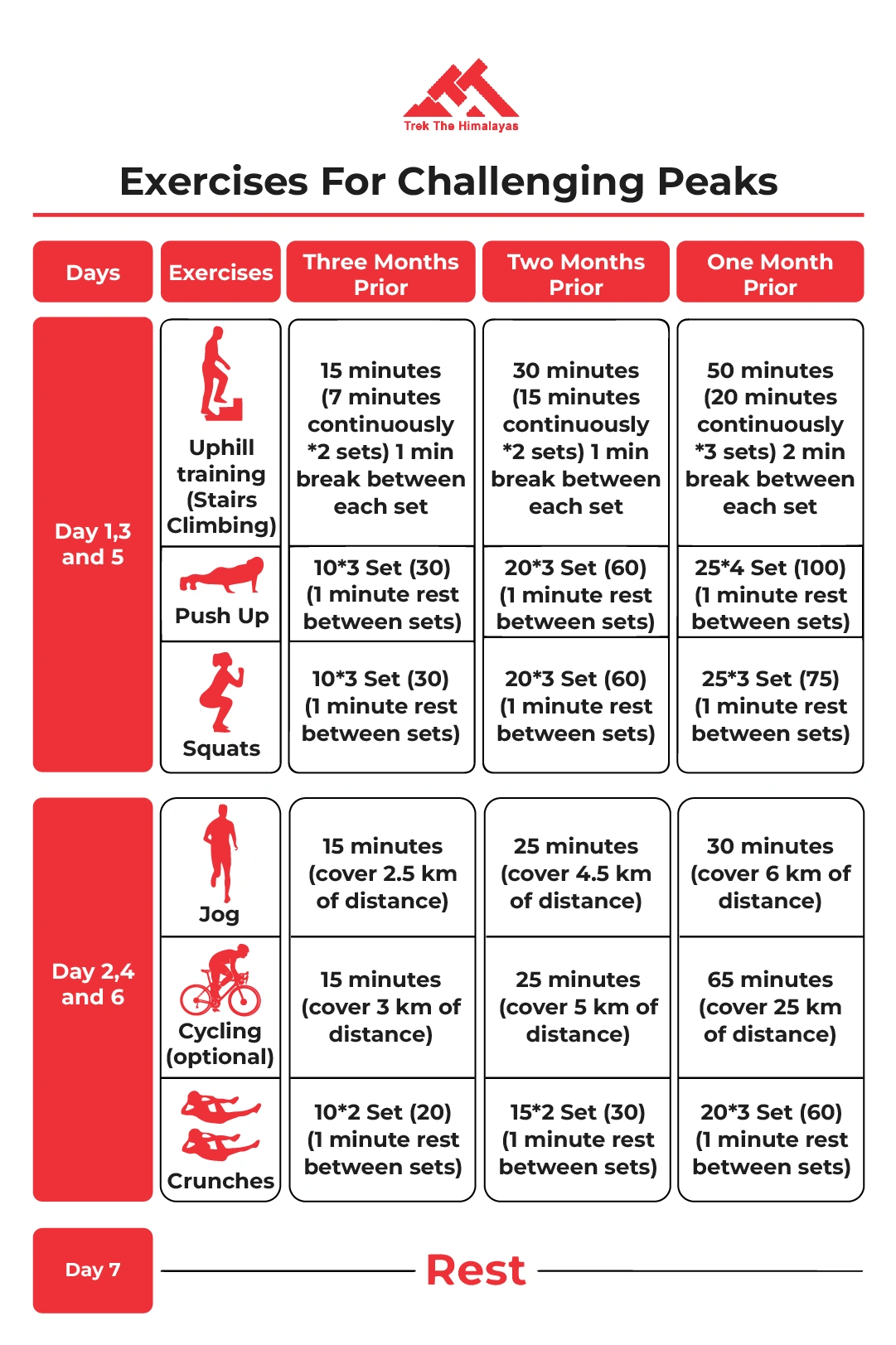
Preparing for the Rudugaira Peak Expedition requires a combination of physical training, mental preparation, and proper gear.
Here are some tips on how to prepare for this challenging trek:
1. Cardiovascular training: The Rudugaira Peak Expedition involves trekking at high altitudes and climbing steep terrain, so it is important to focus on cardiovascular training to build endurance. Activities such as running, cycling, and hiking are great ways to prepare.
2. Strength training: Building strength in your core, legs, and upper body will help you tackle the steep and technical terrain. Focus on exercises such as squats, lunges, push-ups, and pull-ups.
3. Acclimatization: The Rudugaira Peak Expedition involves trekking at high altitudes, which can cause altitude sickness. It is important to acclimatize properly by spending a few days at high altitude before attempting the trek.
4. Mental preparation: Trekking at high altitudes can be mentally challenging, so it is important to prepare your mind for the journey. Focus on staying positive, setting achievable goals, and staying motivated.
5. Proper gear: Having the right gear is essential for a successful trek. Make sure you have all the necessary equipment and that it fits properly.
6. Consult with a doctor: It is recommended to consult with a doctor before embarking on the Rudugaira Peak Expedition, especially if you have any pre-existing medical conditions.
7. Hire a reputable trekking company: It is important to go on this expedition with a reputable trekking company that provides experienced guides and support staff who can assist with technical aspects and ensure your safety throughout the journey.
The Rudugaira Peak Expedition is a challenging and high-altitude trek that requires proper preparation, experience, and the right equipment. However, with the help of an experienced and reputable trekking company, the Rudugaira Peak Expedition can be a safe and enjoyable experience. It is important to note that trekking in the Himalayas involves some inherent risks, including weather changes, steep terrain, and altitude sickness. It is crucial to follow the guidelines provided by your trekking company, including acclimatization schedules, safety protocols, and weather updates.
The altitude of Rudragaira Peak Expedition is 19,086 ft.
To undertake the Rudragaira Peak Trek Expedition, several permits are required as it is located in a protected area. The permits include Uttarakhand Forest Department Permit, Gangotri National Park Permit, Swargarohini Forest Permit. When youtrek with us, Trek The Himalayas obtains all the necessary permit for you.
Explore Most Informative Articles on Rudragaira Peak Expedition
Top 16 Trekking Peaks in Himalayas 2025
Explore the top 16 trekking peaks in the Himalayas for 2025, offering adventures for all levels of trekkers. From beginner-friendly peaks like Kedarkantha at 12,500 ft to the challenging climbs of Mera Peak at 21,247 ft, there’s something for every adventurer. Embark on a thrilling journey to Pangarchulla, Kanamo, Yunam, and Stok Kangri, among others, each promising breathtaking views, rugged landscapes, and a unique Himalayan experience. Whether you're seeking moderate treks through lush meadows or a technical challenge at altitudes above 20,000 ft, these peaks offer unparalleled beauty and excitement. Discover detailed information about the best trekking routes, difficulty levels, altitude, and best time to visit for each peak. Start planning your 2025 Himalayan adventure today and ...
Explore the top 16 trekking peaks in the Himalayas for 2025, offering adventures for all levels of trekkers. From beginner-friendly peaks like Kedarkantha at 12,500 ft to the challenging climbs of Mera Peak at 21,247 ft, there’s something for every adventurer. Embark on a thrilling journey to P...
Trekking in Uttarakhand, Uttarakhand Treks
Experience the best of trekking in Uttarakhand with Trek The Himalayas. Our diverse range of treks offers an unparalleled opportunity to explore the scenic trails, breathtaking views, and unforgettable adventures in the heart of the Himalayas. From the lush green valleys and pristine rivers to the towering snow-capped peaks, Uttarakhand provides a perfect backdrop for trekking enthusiasts. Whether you're a seasoned trekker or a beginner, our well-curated treks cater to all levels of experience. Journey through iconic routes like the Kedarkantha Trek, known for its stunning winter landscapes, or the Valley of Flowers, famous for its vibrant flora. Traverse the challenging Roopkund Trek with its mystical lake or the serene Har Ki Dun Trek, rich in culture and history. Start your adventure...
Experience the best of trekking in Uttarakhand with Trek The Himalayas. Our diverse range of treks offers an unparalleled opportunity to explore the scenic trails, breathtaking views, and unforgettable adventures in the heart of the Himalayas. From the lush green valleys and pristine rivers to th...
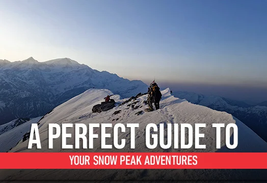
A Perfect Guide to your Snow Peak Adventures
Unlock the secrets to snow peak adventures with Trek The Himalayas through our comprehensive guide designed to elevate your mountain experience. This guide offers essential insights and tips for conquering snow-capped peaks, ensuring you’re well-prepared for the challenges and wonders of high-altitude trekking. From choosing the right gear to understanding the best routes and acclimatization techniques, our guide provides valuable information to enhance your adventure. Learn about the unique aspects of trekking in snowy conditions, including safety measures, navigation tips, and how to adapt to changing weather. Whether you’re an experienced trekker or new to snow peaks, our guide will help you confidently face the adventure, making your journey to new heights both thrilling and memorab...
Unlock the secrets to snow peak adventures with Trek The Himalayas through our comprehensive guide designed to elevate your mountain experience. This guide offers essential insights and tips for conquering snow-capped peaks, ensuring you’re well-prepared for the challenges and wonders of high-alt...


