.webp)
Black Peak Expedition
.webp)
Black Peak Expedition

Region
Uttarakhand | India

Duration
15 Days

Max Altitude
20950 Ft.

Trekking Km
98 KM

Grade
Challenging
Get in Touch with Our Trek Expert
91 8191004846 info@trekthehimalayas.comMonday - Saturday: 10 AM to 06 PM (GMT +5:30)
80000 /Person
- 5% GST will be applicable on Trek Cost and Add-ons
- Services Dehradun to Dehradun.l
Add-ons
Offload 6500
- Backpack offload is optional.
- Choose add-ons during booking. If missed, log in and add them later.
- Book off-load at least 10 days before the trek.
- For offline bookings at the base camp, a convenience fee of Rs. 6900 applies.
- In the event that you choose to cancel your trek prior to the departure date, you will receive a full refund.
Get in Touch with Our Trek Expert
91 8191004846info@trekthehimalayas.com
Monday - Saturday: 10 AM to 06 PM (GMT +5:30)
Overview
Trek Name: Black Peak Expedition
Days: 15
Adventure Type: Mountaineering
Base Camp: Sankri
Season:Summer | Autumn |
Month:June |
Country: India
Altitude: 20950 Ft.
Grade: Challenging
Rail Head: Dehradun
Stay: Guest house & Camping (Twin sharing)
Food: Meals while on trek & Guest house (Veg & Eggs)
Location: Uttarakhand
Distance: 98 Km.
Trail Type: Point to point trail | Camping at the same location upon returning.
AirPort: Jolly Grant Airport, which is 28 km away from Dehradun
Highlights:
- 5% GST will be applicable on Trek Cost and Add-ons
- Services Dehradun to Dehradun.l
Why Black Peak Expedition is a Must-Do Trek ?
Impressive Altitude:
- Black Peak, also known as Kala Nag, stands at an awe-inspiring altitude of 6,287 m.
- It is the tallest peak in the Bandarpoonch Massif, adding to the allure of the expedition.
Adventure of a Lifetime:
- Climbing Black Peak marks an adventure of a lifetime, showcasing the indomitable spirit of human exploration.
Bandarpoonch Massif:
- The Bandarpoonch Massif comprises three peaks, including Black Peak, making it a significant geological feature.
Govind National Park:
- The trail passes through the Govind National Park, offering a chance to witness diverse flora and fauna in the Gangotri Region.
Who Can Participate
- Age Requirements:
- Minimum 18 years
- For Indian citizens: A basic mountaineering course is required.
- For non-Indian citizens: Must have successfully climbed at least one peak over 6,000m.
- Fitness Criteria:
- Trekkers must be able to carry a 10-15 kg backpack, as off-load options are not recommended.
- If a trekker's BMI is more or less than the normal range (18-25), please consult our Trek Coordinator before booking.
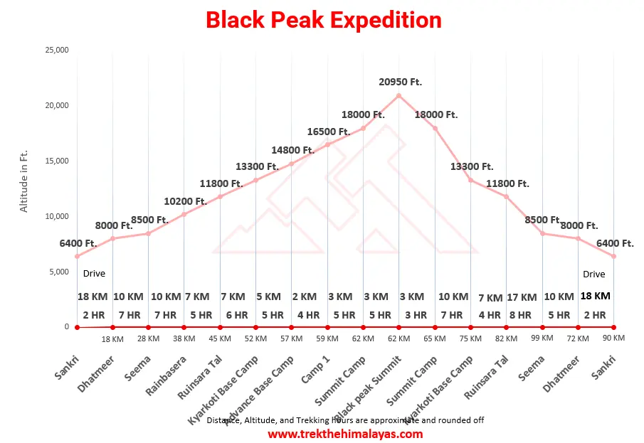
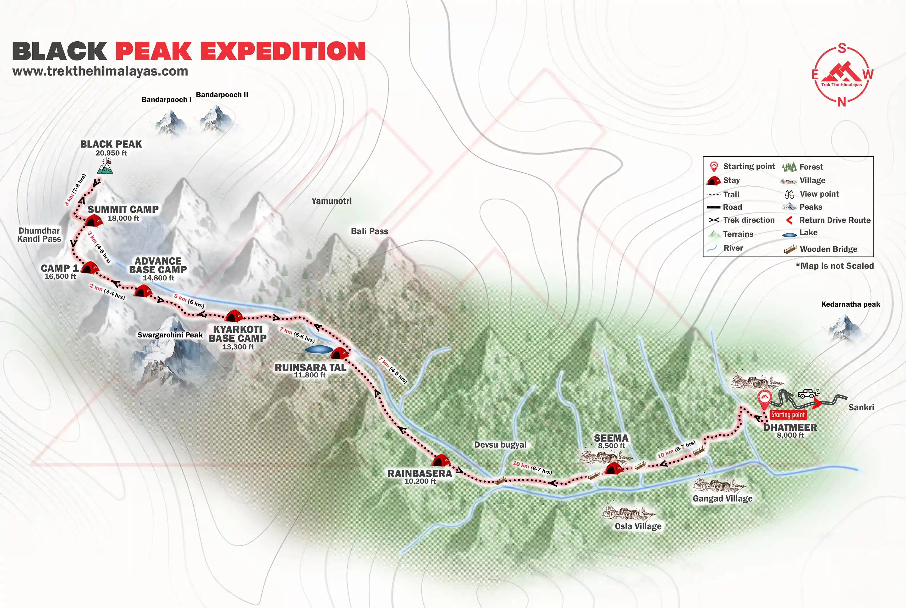
Black Peak Expedition Itinerary
Dehradun to Sankri
- Altitude: 1,950m/6,400ft (Sankri).
- 220 km drive - approx 10 hours.
- Pick up time 06.00 am from Prince Chowk, Dehradun.
- Expected arrival time to Sankri – 5:00 pm.
- Keep the original and copy of ID proof handy, have to show it at the forest check post of Sankri.
- Available network BSNL (erratic).
- Breakfast and lunch on the way (not included in the cost).
- After Pulora keep a warm jacket handy.
- Local Market is available.
- Full functioning AMT at Pulora.
- Sankri is the last road heading to the Govind Balabh Pant Wildlife Sanctuary.
- Dinner at the guest house (included in the cost).
- Stay in a Guest House (twin or triple sharing).
Our journey starts from Dehradun where we will pick you up in Tata Sumo or similar vehicles at 6:30 AM. You are requested to report at the pickup point by the time. From Dehradun, we will drive to Sankri, which is at a distance of 220 km from Dehradun. It may take about 8 - 9 hrs or more to reach Sankri as the mountain roads can be quite bumpy at times. However, the road to Sankri is quite scenic.
On your way, you will cross picturesque places like Mussoorie, Mori, Naitwar, etc. You will drive along the beautiful Yamuna and Tons Rivers with pine trees lining the road. The River is milky white in some places and clear green in others. The fragrance of pinewood and the beauty of nature will make up for the long ride to Sankri. The last stretch of the road, about 22 km from Sankri, is even more beautiful as you enter the Govind National Park, famous for being home to much exotic flora and fauna. On reaching Sankri, we will check in at our hotel. After freshening up, you can spend the evening at the quaint hamlet of Sankri at your leisure.
You can head out for a stroll through this charming village. Sankri is a trekkers’ hub as it is the base camp for not one or two but 11 Himalayan treks including popular treks like Har Ki Dun. At Sankri BSNL network is available but it is very erratic. You can also watch a beautiful sunset at Sankri Village in the backdrop of the Himalayas, a great opportunity for shutterbugs to capture all the beauty around. At night, you can have dinner at your hotel or in the local village dhabas to get a taste of the local flavours. Stay overnight at Sankri and we will start our trek the following day.
Sankri to Seema via Dhatmeer
- Altitude: 2,600m/8,500ft (Seema) and 2,400 m/ 8,000 ft (Dhatmeer).
- Sankri to Dhatmeer drive: 18 km | 1-1:30 hrs
- Dhatmeer to Seema trek: 10 km | 6 - 7 hrs
- Most of the trail is a gradual ascent.
- Walk through the Supin River.
- Trek is in the forest of Deodar trees, Bamboo, wild roses, irises and chestnuts.
- Enough source of water on the way.
- Osla village is opposite to Seema.
- Packed lunch on the way.
- Stay in a tent (Twin sharing).
After breakfast, we will start early in the morning and drive to Dhatmeer from where the actual trekking begins. Dhatmeer is about a distance of 18 km from Sankri and we will reach there in approximately 1 to 1.5 hours. From Sankri you will drive through covers of Bamboo and Deodar trees and cross many streams along a zig-zag road to Sankri. There is also a camping ground near the Forest Rest house in Taluka and in some cases, people camp here as well.
From Dhatmeer, our trekking starts and we will trek a distance of 10 km to reach our Seema campsite. Seema is on the right side of the Thamsa River and we will trek through a dense forest covered with Walnuts, Chestnuts, Willows, and other coniferous trees to reach Seema. The path along the River is stony. After a few hours of walking by the River and crossing some streams, you will arrive at Gangad Village and it will give you a glimpse of the typical Himalayan architecture. 20 minutes further walk and you will reach the water run mill and a Dhaba.
After trekking for another hour, you will reach an opening to a construction site. The concrete construction is actually for a proposed school in the area. You will spot a wooden bridge that will take you to Osla. Osla Village has become quite a popular tourist destination due to its unique architecture and the presentation of Garhwali culture. Osla is home to about 200 families and you can observe the vibrant Himalayan lifestyle in the village.
Seema campsite is only a tourist shelter point and it is not a village or settlement, Seema is just opposite Osla, on the other side of the River. Walking for about another hour, along the River you will reach Seema, where we will set up our camps and stay for the night. The path remains covered in snow and slush during winters.
Seema to Rainbasera
- Altitude: 3,100m/10,200ft.
- Altitude difference: 500m/1,700ft.
- Trek: 10km, 6-7 hours.
- Moderate to difficult ascent and descent.
- Can see the confluence of the Har Ki Dun and Ruinsara rivers.
- Magnificent view of Black Peak (Kala Nag) from Debshu Bugyal.
- Trek along with the Ruinsara River.
- Mixed scenery of forest, meadows and boulders.
- Enough source of water.
- Packed lunch for the day.
- Stay in a tent.
Today we will trek along the Supin River to Devsu Bugyal and cross the Devsu Bugyal meadows, we will descend through a forest cover and a sandy and stony path down to the riverbed. Crossing the Supin River we will again trek along the river banks, the river now on our right to our campsite at Rain Basera. The path may also be a little slippery towards the end so be cautious.
The trail begins with Supin River on the left and while ascending, the path soon becomes steep as you get closer to Devsu Bugyal, climbing up, you will get the views of Osla Village behind you and as you enter the Ruinsara Valley, the path becomes filled with boulders adding more challenge to your trek. 30 minutes further walk will bring you into Devsu Bugyal meadows and the meadow stretches for about 2 km. We will rest here for a while appreciating the natural beauty and witnessing the views of Kala Nag peak and Swargrohini in the backdrop.
The Devsu Bugyal meadows are set amidst the Ruinsara forest and while ascending towards Devsu Bugyal, you will see a variety of Himalayan wildflowers and foliage. The forest is also home to many bird and animal species as well and hiking through the forest, you may even spot some rare species along the way.
From Devsu Bugyal, there is an abrupt drop in the trail and you will have to descend all the way down to the riverbed. The path is filled with sand and stones and you will cross the bridge to get across the river this time, the River Supin will transfer to your right while it was on your left when you began the trek. Walking beside the river, you will now have to ascend once again. The trail has quite a steep ascent until Rain Basera, your next camping spot. After a steep climb, you will reach your campsite at Rainbasera. The Rain Basera campsite is very peaceful and it also has one small hut. After an arduous climb, you can just relax here in the evening and enjoy the serenity. The Supin River gushing along is a beautiful sight to behold. At night, we will have our dinner and sleep in tents.
Rainbasera to Ruinsara Tal
- Altitude: 3,600m/11,800ft.
- Altitude difference: 500m/1,600ft.
- Trek: 7 km, 4-5 hours.
- Moderate ascent.
- Ruinsara Lake is surrounded by meadows and rhododendron bushes.
- Mixed trail of boulders and meadows.
- Can see the waterfall on the way.
- Enough source of water.
- View from camp site: Yamuna Kanta (the pass which takes you to Yamunotri), Banderpooch Peak, Dhumdhar Kandi Black Peak (Kala Nag) and White Peak.
- Packed lunch on the way and light lunch at camp site. Camping near by the lake.
- Stay in tent.
Today is an exciting day of our trek as you will trek to the beautiful glacial lake, Ruinsara Tal. Its a 7 km trek to Ruinsara Tal and after walking for about 4 to 5 hours you will arrive at the lake and we will also camp beside this lake at night.
The lovely Ruinsara Lake is surrounded by meadows and Rhododendron blooms, which amplifies its beauty. The campsite is wonderfully nestled in a location where on one side is the Ruinsara Lake and on the other side the Supin River. The views from the campsite are equally as beautiful as the lake. You will see Yamuna Kanta on the southwest side, the pass that will take you to Yamunotri, the source of the Yamuna River. On the east lies the majestic mountains, the Bandarpunch Peak, and Dhumdhar Kandi Range, and on the southeast, you can see Kala Nag and White Peak.
You can spend the evening at your leisure and explore the area, and take some beautiful pictures. At night we will enjoy a hot dinner at the campsite and retire in your tents for a good night’s sleep.
Ruinsara Tal to Kyarkoti (Base Camp)
- 4,050m/13,300ft.
- Altitude difference: 450m/1,500ft.
- 7 km, 5-6 hours.
- Gradual ascent.
- Enough water source.
- Kyarkoti is also known as the Black Peak base camp.
- Base camp is at the foothill of Swargarohini.
- Bandarpoonch glacier can be seen.
- Base camp is a meadow covered by boulders.
As you begin your journey towards Black Peak Base Camp, the Black Peak gradually begins to come into view. Today’s walk is quite a bit challenging and you will cross valleys and bouldered sections. Glorious mountain views greet you on both sides. It’s quite a steep climb to Kyarkoti and the bouldered patch adds to the difficulty.
About an hour into the trek, you will arrive at a landslide-prone area. Be cautious and follow the guidance of your trek leader and guide. Crossing this landslide section, you will enter into a grassland patch, the Rupin River beautifully flows down below. You will be walking uphill and downhill for quite some time crossing hill after hill, crossing water bodies flowing directly from the glaciers and a rough bouldered patch before you arrive at Kyarkoti. The bouldered section is approximately 3 km and completely inclined.
Once you arrive at Kyarkoti campsite, you will notice that Kyarkoti is a huge patch of grassland surrounded by boulders and snow-covered peaks. The campsite is situated right below the foothills of Swargarohini peaks. There’s also a campsite that runs by the campsite. As you settle on the campsite, you can get quite a good glimpse of your ultimate goal - the Black Peak. The evenings tend to be quite cold so keep warm layers in the ready.
Base Camp to Advanced Base Camp (ABC)
- Altitude: 4,500m/14,800 ft.
- Altitude difference: 450m/1,450ft.
- Trek: 5 km, 5 hours.
- Moderate ascent.
- Enough water source.
- Moraine walk.
- ABC is at the front of Black Peak and next to Bandarpoonch Glacier.
After the Kyarkoti Camp or Black Peak Base Camp, there are 3 camps before the summit and ABC is the first one. From Kyarkoti we will head towards the Advanced Base Camp. The trail to Advanced Base Camp takes you through varied terrains from grasslands to a bouldered section which is followed by quite a steep climb through a landslide-prone area onto a moraine patch and finally to a glacier. It takes about 5 hours to climb to the Advanced Base Camp.
As you climb up towards the Advanced Base Camp the path becomes narrower so be cautious and follow the advice and guidance of the Trek Leader at all times. Be especially wary of the landslide zone. Halfway through the trek, you will get your first sightings of the Bandarpoonch I and the frozen glacier stream flowing from it. Even from a distance, you can spot the huge crevasses. The last leg of the trek is especially difficult with big cracked rocks fallen from the mountain along with the sand and dust.
Finally walking for about 5 to 6 hours depending on your pace, you arrive at the Advanced Base Camp. The campsite is surrounded by towering mountain peaks. Bandarpoonch stands tall in front of you in all its glory and the majestic views are enough to take all your tiredness away.
The altitude of the Advanced Base Camp is quite high and the temperature drops very drastically in the evening and is quite windy as well so layer yourself up for protection against the cold. Sleep well as you have many adventurous days ahead.
Rest/ Acclimatization/ Load Ferry
- Trek Leader will decide how to utilize this day.
Since we will be gaining a lot of altitude in the upcoming days, it is necessary that we take a rest day and acclimatize well to the altitude. Acclimatizing the body to terrain, altitude, and temperature is highly crucial to avoid AMS.
Today you will also be introduced to the gears that you will be using during the upcoming days and receive training on using the gears, walking skills, tying knots, using an ice axe, etc. Enjoy the evening and rest well at night. The next few days are going to be incredibly thrilling.
Advanced Base Camp (ABC) to Camp 1
- Altitude: 5,050m/16,500 ft.
- Trek: 2 km, 3-4 hours.
- Difficult ascent.
- Enough water source.
- Mixed walk of moraine and glacier.
- Black peak is clearly visible from this camp.
- Camp is Just next to Glacier.
Today you will head to Camp 1. As you ascend from Advanced Base Camp to Camp 1, you will be greeted with the views of Swargarohini on the North and Bandarpoonch on the south. The terrain that you will cross today will be full of crevasses so be extra cautious. The trek distance is not as much so take your time to adapt to the terrain and make your way safely forward.
Although today’s trek is short, it can be slightly draining because of the altitude gain. The trail is pretty tricky to navigate as well. Sometimes the trail is visible and then becomes narrow and even disappears at times. The trail is pretty inclined and filled with rocks and boulders making it quite challenging. The landscape changes pretty drastically. From the dry lands at the base of the mountains, you will soon arrive at the dry glacier beds.
After about 2 hours of walking through rugged terrains, you will arrive at Camp 1. Settle in the campsite and take in the wonderful views around you, soon you will be submitting the Black Peak itself. You can walk around the campsite and get yourself acquainted with the terrain. The sunset from Camp 1 is especially beautiful, the colours of the setting sun paint the sky and the snow-covered peaks in vivid hues creating a mesmerizing visual treat.
Once the sun sets, it increasingly becomes colder and colder and the wind also kicks up in speed. Make sure that you have enough warm layers on. You will have a delicious dinner before retiring to your tents. Tomorrow you will be heading to the Summit Camp.
Camp 1 to Summit Camp
- Altitude: 5,500m/18,000 ft.
- Altitude difference: 450m/1,500ft.
- Trek: 3 km, 4-5 hours.
- Moderate ascent.
- No water source only snow.
- Mostly Glacier Walk with open and hidden crevasses.
- Experienced trek leader and guide is needed to show the route.
- Dhumdhar Kandi Pass can be seen on the left side while trekking.
Wake up to a beautiful morning with the sun casting a golden glow on the Black Peak and Bandarpoonch I. Take a few minutes to appreciate the magnificent play of nature. After having breakfast at Camp 1, we will be heading towards Summit Camp. Today and tomorrow are the most important days and also the most adventurous. While the distance today is short, just about 3 km but the previous days walk will give you an idea of how difficult the terrain could be.
Today, you will be walking completely over snow and working together as a team as you approach the summit. The climb begins with a gradual incline and once you have made up the incline section, you arrive at a flat surface that opens up the full view of Black Peak. You can capture the majestic beauty of Kalanag in your cameras here. You can also see enormous crevasses and small snow bridges on your way. White-covered mountain ranges surround you on all sides and it just appears surreal to all the senses.
The journey to the Summit Camp will be full of ups and downs, sometimes you will climb steep inclines and sometimes you will be walking on flat trails as well. There is a quick elevation gain so maintain a steady pace and do not over-exert yourself. Crossing ice bridges, navigating around crevasses, and climbing over steep sections with knee-deep snow at times, you will arrive at the summit camp.
The wind catches speed by minute as the evening sets in and the temperature is going to be subzero in this campsite. You will have a delicious evening snack and a hearty dinner before you go to sleep. The most thrilling day awaits you tomorrow.
Summit Camp to Summit Attempt (Black Peak)
- Altitude: 6,387m/20,950 ft.
- Altitude difference: 890m/2,900ft.
- Trek: 3 km, 7-8 hours (one way).
- Technical ascent with 75 to 100 feet vertical wall.
- Fixed rope climbing system is required.
- Start summit push by 02:00 am.
This is the day you have been anticipating all along your journey. Today, we will be attempting to summit the majestic Black Peak. This is going to be an in interesting experience as we will be pushing for the summit after midnight. We start towards the summit around 1’o clock. This is the big day everyone has been waiting for. After a complete check by our team, we will start towards the summit.
The only light that you have at this hour is from the headlamps so be extra cautious as you move forward. Approaching the summit today is all about tackling the heavy snow covers and maintaining a steady pace as you keep gaining elevation. You will be navigating around crevasses that aren’t as easily visible which adds to the challenge of the trek.
The entire trek today is inclined and completely covered with layers of snow. Follow the steps created by your Trek Leader on the snow. Around the break of dawn, as the first rays of sun hit the slopes, you will be mesmerized by the sight of such huge mountains surrounding you on all sides. The morning glow of the sun casts its golden shadow on the snow-covered peaks basking them in the golden hour glory. It is a sight that remains imprinted on your memory forever.
The trek to the summit in the final leg follows a zig-zag path and soon you will arrive at the summit of the Black Peak. For the last 500 m, you will rope up with your team and climb up. This may just be the hardest climbing experience for you. Soon you will find yourself standing at the summit of the mighty Black Peak. It is a divine feeling, standing atop this mountain and watching many Himalayan peaks up-close that seem just a stone’s throw away. Sit down for a while and enjoy the grand summit views. After spending about 30 minutes at the summit, we will begin our descent to the summit camp.
The descent will be much quicker than climbing up and in about 3 hrs you will arrive at the summit camp once again. Tonight we will stay at the summit camp and descend to the base camp the following. Sleep well with the sense of accomplishing the summit to Black Peak. It’s a great achievement for any adventure lover.
Summit Camp to Base Camp
- Altitude: 4,050m/13,300 ft.
- Altitude difference: 1,000m/3,300ft
- Trek: 10 km, 6-7 hours.
- All descent.
Kyarkoti Base Camp to Ruinsara Tal
- Altitude: 3,600m/11,800ft.
- Altitude difference: 900m/2,950ft.
- Trek: 7 km, 4 hours.
- Enough water source.
Today we will be heading towards the beautiful Ruinsara Tal that you crossed on the 4th day of the trek. We will start our journey after breakfast as usual. The descent to Ruinsara Tal is a combination of incline and decline.
Walk over grassy slopes, cross over mountains and walk under waterfalls as you make your way to the serene Ruinsara Tal. Today we will camp beside the tranquil lake basking in the peacefulness of the surroundings. Ruinsara Tal campsite is a fresh change of scenery after spending so many days without vegetation in sight.
Ruinsara Tal to Seema
- Altitude: 2,600m/8,500ft.
- Altitude difference: 1000m/3.300ft.
- Trek: 17 km, 8 hours.
- Enough water source.
From Ruinsara Tal the trail is mostly a descent all the way to Seema. Today you will be walking for 17 km, the longest trekking day so far. The trail from hereon is well-marked and much wider than the one you have been climbing up on and thus the navigation was much easier. Soon you will reach a wooden bridge with the Rupin River flowing under it. Be very carefully while crosisng the bridge and soon you will arrive at the location where you had your first sighting of Black Peak and Bandarpoonch. From here, the walk is much easier till Seema and once you reach the village you will again be in civilization after a couple of days. After a hearty day, we will call it a day.
Seema to Dhatmeer and Drive to Sankri
- Altitude: 2,400 m/ 8,000 ft (Dhatmeer), 1,950m/6,400ft (Sankri).
- Seema to Dhatmeer trek: 10 km | 5 hrs
- Dhatmeer to Sankri drive: 18 km | 1-1:30 hrs
Start your day with a hearty breakfast. Today you will hike from Seema village to Dhatmeer and drive back to Sankri. Start walking by the Thamsa River and along pine forests. In about 5 hrs you will arrive at Dhatmeer, the point from where you started your trekking journey. From Dhatmeer, you will be driven to Sankri. You can finally take a fresh shower at the guest house. You can spend the evening at your leisure, roaming around the village.
Drive to Dehradun
- 220 km drive, approx 10 hours.
- Driving Time - 7 am - 6 pm.
- Breakfast and lunch excluded.
- You will be dropped at Dehradun station in a Tempo Traveller or a similar vehicle.
Today is the day you bid adieu to the mountains. Well start for Dehradun early in the morning. Tata Sumo or other similar vehicles will be arranged for you at Sankri to drive you back to Dehradun. We have to cover a distance of 220 km and it will take about 10 hrs so the earlier we start the better. We will return through the same road that we came on the first day. Cherish the nature around with picturesque vistas stretching alongside far and wide. We will reach Dehradun by 6:00 PM so make your further bookings accordingly.
Day 16 & 17: Buffer day.
- Buffer day will be used if unable to summit due to of any unforeseen circumstances.
- Opting a buffer day will be a team decision not an individual.
- Keep a buffer day in your travel plan.
- Buffer day is not included in the cost.
- If buffer day is not used in the Expedition then it can be used to explore Rishikesh/Haridwar/ Mussoorie .
- Rishikesh is known for White water Rafting capital of India, Bungee jumping, Yoga, Ayurvedic Massage, Ram Jhula, Lakshman Jhula, Parmarth aarti, Big ashrams.
- Haridwar is known for Pilgrimage, Numerous temples, Har Ki Pauri, Ganga Aarti, Jungle safari in Rajaji National Park, Ayurvedic medicines and herbal remedies.
- Mussoorie is known for Mall Road, Shopping, Kempty Falls, Municipal Garden, and Sir George Everest house.
- Distance, Altitude, and Trekking hours are approximate and rounded off
- Keep the original and copy of ID proof handy
- Come one day early if planning to come by plane
Day-1: Dehradun to Sankri
- Altitude: 1,950m/6,400ft (Sankri).
- 220 km drive - approx 10 hours.
- Pick up time 06.00 am
Day-2: Sankri to Seema via Dhatmeer
- Altitude: 2,600m/8,500ft (Seema) and 2,400 m/ 8,000 ft (Dhatmeer).
- Sankri to Dhatmeer drive: 18 km | 1-1:30 hrs
- Dhatmeer to Seema trek: 10 km | 6 - 7 hrs
Day-3: Seema to Rainbasera
- Altitude: 3,100m/10,200ft.
- Trek: 10km, 6-7 hours.
Day-4: Rainbasera to Ruinsara Tal
- Altitude: 3,600m/11,800ft.
- Trek: 7 km, 4-5 hours.
Day-5: Ruinsara Tal to Kyarkoti (Base Camp)
- Altitudece: 4,050m/13,300ft.
- Trek: 7 km, 5-6 hours.
Day-6: Base Camp to Advanced Base Camp (ABC)
- Altitude: 4,500m/14,800 ft.
- Trek: 5 km, 5 hours.
Day-7: Rest/ Acclimatization/ Load Ferry
- Trek Leader will decide how to utilize this day.
Day-8: Advanced Base Camp (ABC) to Camp 1
- Altitude: 5,050m/16,500 ft.
- Trek: 2 km, 3-4 hours.
Day-9: Camp 1 to Summit Camp
- Altitude: 5,500m/18,000 ft.
- Trek: 3 km, 4-5 hours.
Day-10: Summit Camp to Summit Attempt (Black Peak)
- Altitude: 6,387m/20,950 ft.
- Trek: 3 km, 7-8 hours (one way).
Day-11: Summit Camp to Base Camp
- Altitude: 4,050m/13,300 ft.
- Trek: 10 km, 6-7 hours.
Day-12: Kyarkoti Base Camp to Ruinsara Tal
- Altitude: 3,600m/11,800ft.
- Trek: 7 km, 4 hours.
Day-13: Ruinsara Tal to Seema
- Altitude: 2,600m/8,500ft.
- Trek: 17 km, 8 hours.
Day-14: Seema to Dhatmeer and Drive to Sankri
- Altitude: 2,400 m/ 8,000 ft (Dhatmeer), 1,950m/6,400ft (Sankri).
- Seema to Dhatmeer trek: 10 km | 5 hrs
- Dhatmeer to Sankri drive: 18 km | 1-1:30 hrs
Day-15: Drive to Dehradun
- 220 km drive, approx 10 hours.
- Driving Time - 7 am - 6 pm.
Note:
Day 16 & 17: Buffer day.
- Buffer day will be used if unable to summit due to of any unforeseen circumstances.
- Opting a buffer day will be a team decision not an individual.
- Keep a buffer day in your travel plan.
- Buffer day is not included in the cost.
- If buffer day is not used in the Expedition then it can be used to explore Rishikesh/Haridwar/ Mussoorie .
- Rishikesh is known for White water Rafting capital of India, Bungee jumping, Yoga, Ayurvedic Massage, Ram Jhula, Lakshman Jhula, Parmarth aarti, Big ashrams.
- Haridwar is known for Pilgrimage, Numerous temples, Har Ki Pauri, Ganga Aarti, Jungle safari in Rajaji National Park, Ayurvedic medicines and herbal remedies.
- Mussoorie is known for Mall Road, Shopping, Kempty Falls, Municipal Garden, and Sir George Everest house.
- Distance, Altitude, and Trekking hours are approximate and rounded off
- Keep the original and copy of ID proof handy
- Come one day early if planning to come by plane
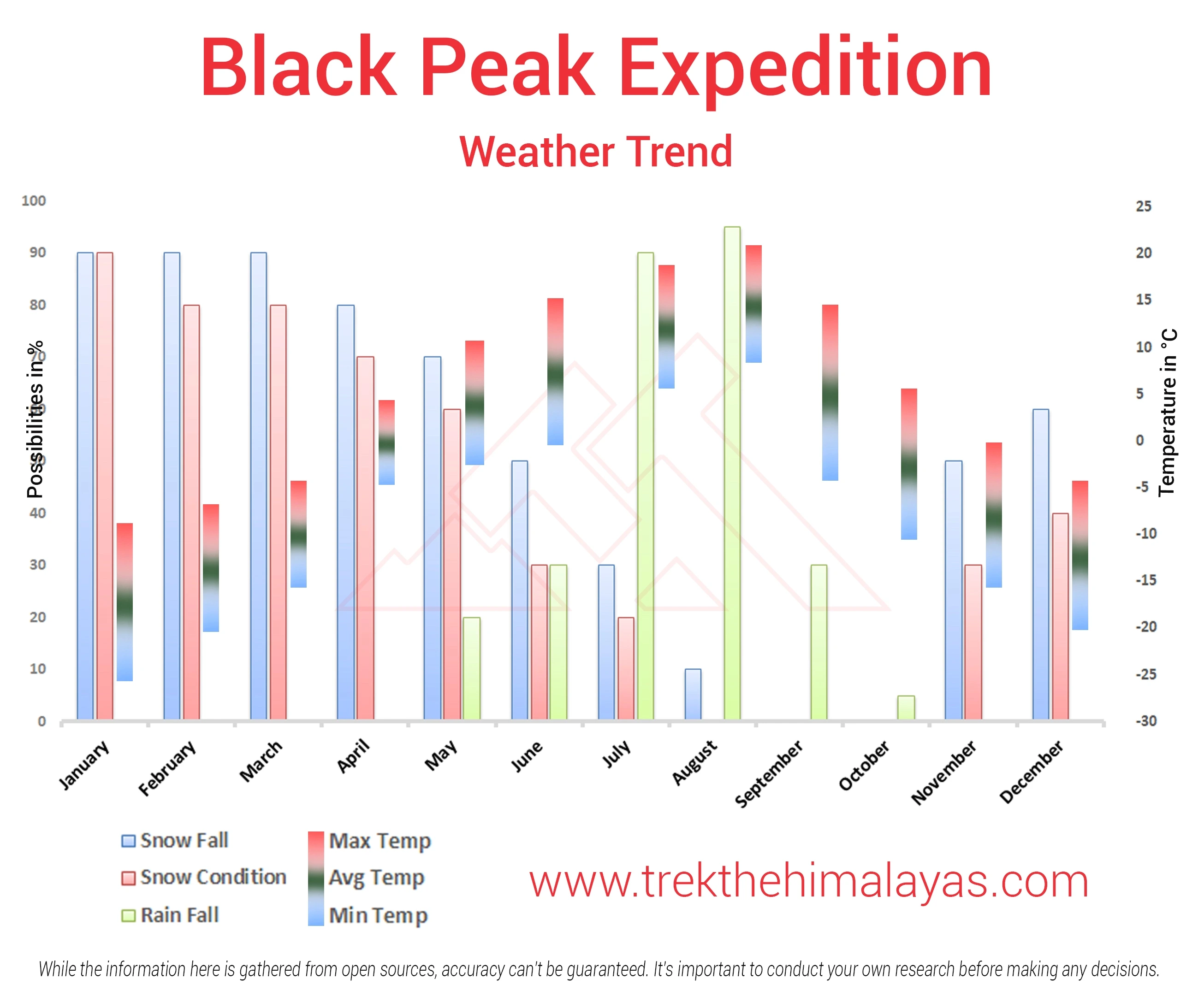
Black Peak Expedition Graph
- Pulse rate at rest must be in between (60 to 100 beats per minute).
- Blood Pressure Reading must be in between (DIASTOLIC 75 – 85, SYSTOLIC 100 - 130 mm Hg).
- Respiratory rate at rest must be in between (12 to 20 breaths per minute).
- Should not have Liver and kidney issues.
- Should not have Diabetes Mellitus, Bronchial Asthma, Heart problems, Hypertension, etc.
- No pacemaker implant.
- People with Sinus issues, Epilepsy please contact to trek coordinator before booking the trek.
- If your BMI is not normal, Please contact our Trek coordinator before Trek booking.
Medical & Disclaimer Form (Mandatory Documents) Click here to download Medical & Disclaimer Form
- Government Employees can avail the benefit of Special Casual Leave (SCL) when they join us for a trekking expedition. As per the rules of the Pay Commission, Special Casual Leave can be availed for up to 30 days in a calendar year for trekking/mountaineering expeditions through a registered organization. Trek The Himalayas is a registered adventure tour operator by the Indian Mountaineering Foundation (IMF) and the Ministry Of Tourism (MOT).
- Trekkers have to apply for leave at least 20 days before the trek departure date.
- This service is exclusive to Indian government employees and is applicable only for treks within India.
- Do mail at info@trekthehimalayas to apply and mention your booked trek date and trek name.
- Junior trekkers (below 15 years) should have a company of parents/guardians.
- Trekkers between 15 to 18 years can come solo with the disclaimer form signed by parent/guardian.
- Medical & Disclaimer Form (Mandatory Documents) Click here to download Medical & Disclaimer Form
Important Links
- Mandatory Documents to Bring on A Trek Click Here.
- How to pay Add-ons, Submit Medical Forms, and Dietary Preferences Click Here to watch Video
How To Reach
Pick-Up Information
- It is essential for everyone to arrive at Prince Chowk, Dehradun (06:00 am).
- Once you have reached Dehradun, TTH will manage the rest of your travel arrangements, if you have opted for TTH's pick-up service, you can select this option during the booking process by adding it as an add-on.
Options to Reach Dehradun
First, you can arrive at Delhi, Dehradun Airport or Chandigarh. The journey from these locations to Dehradun is explained below.
1. Take an overnight train from Delhi to Dehradun.
2. Take a bus to Dehradun ISBT from Delhi Kashmiri gate ISBT or Chandigarh Sector 17 Bus stand, and then take local transport to the pickup point (Prince Chowk).
Delhi to Dehradun - 250km | 6hr.
Chandigarh to Dehradun - 220km | 5hr
The distance from the Dehradun Bus Stand (ISBT) to the Railway Station is 6 km, without traffic, it will take 15 minutes.
( We always recommend to go for the govt. Buses over the private ones outside the bus station as based on the experience we have found that there are very high chances of delay involved with private buses. Also, govt. Buses are always more reliable. Whichever bus you choose, just make sure to reach Dehradun at least by 05:30 am positively. )
3. Take a flight to Dehradun airport (Jolly Grant Airport), then from the Airport to Prince Chowk, Dehradun Distance is 30km and it will take around 1 hr( if coming by flight then reach one day early).
Drop-Off Information
- The designated drop-off point is Prince Chowk, Dehradun.
- Arrive in Prince Chowk by 6:30 to 7:30 pm.
- Please consider planning your subsequent travel arrangements after 9:00 pm.
- The distance from the Railway Station to Dehradun Bus Stand (ISBT) is 6 km, it will take approx 25 minutes.
- The distance from Railway Station to Dehradun Airport is 30km, it will take approx 1hr.
- It's highly advisable to keep a buffer day in your travel plan. If the buffer day is not needed, it can be used to explore Dehradun/Mussoorie/Rishikesh.
( If you prefer to travel independently to Base camp and don't want to take TTH's pick-up service, you can either take a government bus or book a private cab from Dehradun. Your trek coordinator will provide guidance on how to arrange for the bus or cab booking. )
TTH offers comfortable transportation through Tempo Traveler, Bolero, or equivalent vehicles. If you wish to upgrade your mode of transportation, please contact your trek coordinator for further assistance.
.webp)
.webp)
Cost Terms
Inclusion
1. Accommodation (as per the itinerary):
- Guest houses on Day 1 & 14 at Sankari (twin sharing).
- Camping during the trek (Day 2 to Day 13).
2. Meals (Veg + Egg):
- All meals are from Sankri to Sankri.
- Day 1 to Day 14 Dinner.
3. Support:
- 1 Versatile base camp manager: handles communication and deploys extra manpower in emergencies.
- 1 Mountaineering & First aid qualified professional expedition Leader.
- 1 Experienced high altitude chef.
- Local experienced guides (Number of guides depending on the group size).
- Enough support staff.
4. Trek equipment:
- Sleeping bag, Sleeping liners (if required), Mattress, Utensils.
- 3 men all season trekker tent (twin sharing), Kitchen & Dining tent, Toilet tent.
- Camping stool, Walkie talkie.
- Ropes, Helmet, Ice axe, Harness, Gaiters & Crampon (if required).
5. First aid:
- Medical kit, Stretcher, Oxygen cylinder, Blood pressure monitor, Oximeter, Stethoscope.
6. Transportation (as per the itinerary):
- Dehradun to Sankri & return.
- Sankri to trekking point & return.
7. Cloakroom service at base camp.
8. Mules/porters to carry the central luggage.
9. All necessary permits and entry fees, up to the amount charged for Indian.
10. Services from Dehradun to Dehradun.
11. Trek completion certificate from TTH.
Exclusion
1. Insurance (Mandatory).
2. Food during the transit.
3.
Any kind of personal expenses.
4. Mule or porter to carry personal luggage.
5.
Emergency evacuation, hospitalization charge or etc.
6. Anything not specifically
mentioned under the head Inclusion.
Things can be provided on demand and availability (participant has to pay extra for these things).
1- Satellite phone/set phone - is a type of mobile phone that connects via radio links via satellites orbiting the Earth instead of terrestrial cell sites like cellphones. Therefore, they can operate in most geographic locations on the Earth's surface.
2- Gamow/PAC HAPO Bag (Portable Hyperbaric Bag) - is a unique, portable hyperbaric chamber for the treatment of acute mountain sickness (AMS), also known as altitude sickness.
3- AEDs (Automated External Defibrillators) - are portable life-saving devices designed to treat people experiencing sudden cardiac arrest, a medical condition in which the heart stops beating suddenly and unexpectedly.
Cancellation Terms
To request a cancellation, please email us at info@trekthehimalayas.com using your registered email ID.
Cancellations prior to 25 days from the start of the Trip
Refund Options
- 5% deduction of trek fee
- 100% cash voucher for any trip till one year
- Transfer your trek (any trek, any date) to your friend
Cancellation between 24 days and 15 days to the start of the Trip
Refund Options
- 30% deduction of trek fee
- 100% cash voucher for same trip till one year
- 85% cash voucher for any trip till one year
- Transfer your trek (same trek, any date) to your friend
Cancellation between 14 days and 10 days to the start of the Trip
Refund Options
- 50% deduction of trek fee
- 80% cash voucher for same trip till one year
- 70% cash voucher for any trip till one year
- Book the same trek, in the same season, with any other batch
- Transfer your trek (same trek, any date) to your friend
Cancellation less than 9 days to the start of the trek.
Refund Options
- No cash refund
- 20% cash voucher for the same trip till one year
- 10% cash voucher for any trip till one year
- Transfer your trek (same trek, same date) to your friend
Cancellation Policy (Emergency Cases):
In case of a death in the immediate family (parents, siblings, spouse, children) or if the trekker is hospitalized (min. 48 hours) or suffers a fracture (leg/arm) within a week before the trek, even if canceled a day before:
90% refund in cash & 10% as a voucher (valid for 1 year, for any India trek)
Valid documents required. We’re here to support you during tough times.
Note- If a booking is made using a voucher or discount code, the policies related to vouchers and discounts cannot be modified.
In the unlikely event that TTH cancels a trek prior to the scheduled departure date:
While it is extremely rare for TTH to cancel a trek, we understand that unforeseen circumstances or natural disasters may occasionally require us to do so before the scheduled departure. These circumstances could include continuous rain or snow, thunderstorms, snowstorms, landslides, floods, earthquakes, or any other natural calamity that poses a risk to the safety of our trekkers. Additionally, unforeseeable events such as local riots, curfews, pandemics, lockdowns, government orders, or any similar situations that compromise the safety of the trekking experience may also necessitate a cancellation.
In the event of such a cancellation, TTH will provide you with a voucher equivalent to the amount you paid for the trek. This voucher can be redeemed for any of our treks within the next year, allowing you to still enjoy an adventure with us at a later date.
Note
-
The issuance of a voucher is not applicable in situations where you are required to descend from the trek for any reason. The trek leader may make the decision to send you down from the trek due to factors such as insufficient fitness level, symptoms of Acute Mountain Sickness (AMS), high blood pressure, exceeding the designated turn-around-time, health concerns, or if you are found smoking, drinking, or violating the rules set for the trek. In such cases, the provision of a voucher does not apply.
In the Rare Event that TTH Shifts a Trek
We would like to emphasize that weather conditions in high-altitude areas are highly unpredictable and can undergo sudden changes at any time, irrespective of the day. Additionally, circumstances beyond our control, such as natural disasters, political unrest, pandemics, and lockdowns, may impact the feasibility of conducting a trek. In cases where we are unable to proceed with an event due to such circumstances that are beyond our direct control, we will make every effort to provide you with an alternative trek that is safer and more suitable.
In such situations, we will issue a voucher to offset the cost difference between the originally scheduled trek and the alternative trek. This voucher can be redeemed at any time within one year from the date of issue. Please note that a refund fee or reimbursement of the cost difference is not applicable in these cases.
Note:
- Change of trek batch is dependent on the availability of seats in the batch
- In case of transferring a trek to a friend, he/she should satisfy all the mandatory requirements put forward by TTH
- TTH holds the right to change/cancel the policies, without prior notice
- Cash refund is applicable only in case of bookings made without using any promotional offer code or vouchers
Cash Voucher Terms
- This is a non-transferable voucher
- The voucher cannot be merged with any other offer of Trek The Himalayas
- The voucher is valid for Trek booked directly with Trek The Himalayas in India
- To avail the voucher please use your register phone number or e-mail id
- All the other Terms of booking a trek with Trek The Himalayas are applicable to the voucher
- Trek The Himalayas holds rights to add/remove any of the Terms and Conditions without prior notice
In the event that your entire group is compelled to abandon the trek after reaching the destination pick-up place, due to reasons such as extreme weather, trail disruption, roadblocks, withdrawal of government permissions, or any other unforeseen circumstances—no cash refund or voucher will be provided. However, most of our treks are covered under our Trek Again Policy, allowing you the opportunity to repeat the same trek at a later date.
Itineraries are based on information available at the time of planning and are subject to change. "Trek The Himalayas" reserves the right to change expedition dates, people or itineraries as conditions warrant. If a trip must be delayed or the itinerary changed due to bad weather, road conditions, transportation delays, government intervention, airline schedules, sickness, or other contingency for which TTH or its agents cannot make provision, the cost of delays and/or other changes are the responsibility of the participant. TTH reserves the right to decline, or accept, any individual as a trip member for any reason whatsoever.
Trek Essentials
Rent EquipmentPDF Of Trek Essential Download
| Backpack with rain cover | (60 - 70 ltr) with comfortable shoulder straps |
| Day pack with rain cover | 20 - 30 ltr |
| Walking stick | Advisable (At least one) |
| Water Bottle / Hydration pack | 2 bottles of one liter each, People who use hydration pack 1 hydration pack and 1 bottle of one liter, Carry at least one thermos flask. |
| Small size tiffin/lunch box | 1 Nos |
| Snacks | Energy bars, dry fruits, electral/ors |
| Personal Medical Kit | Consult your doctor |
| T-Shirt (Synthetic quick dry) | 2 Full & 2 Half sleeves |
| Fleece T-shirt | 2 Nos. |
| Wind stopper / Fleece jacket | 1 Nos |
| Windproof Jacket | 1 Nos. |
| Down feather / Hollow jacket | 1 Nos. |
| Thermal inner (Upper and Lower) | 1 Pair |
| Trek Pant (Synthetic quick dry) | 3 Nos. |
| Wind stopper / Fleece Pant | 1 Nos. |
| Waterproof gloves | 1 Pair |
| Fleece / woollen gloves | 1 Pair |
| Poncho / waterproof Jacket and pant | 1 Nos. |
| Sunscreen | 1 Nos. |
| Moisturiser | 1 Nos. |
| Chap-stick / Lip balm | 1 Nos. |
| Toothbrush and toothpaste | 1 Nos. |
| Toilet paper & Wipes | 1 Nos. |
| Soap / hand sanitizers | 1 Nos. |
| Antibacterial powder | 1 Nos. |
| Quick dry towel | 1 Nos. |
| Head torch | 1 Nos. (Avoid Hand torch) |
| Sun Cap | 1 Nos. |
| Woolen cap | 1 Nos. |
| Balaclava | 1 Nos. |
| Buff / Neck-gaiters | 1 Synthetic & 1 Woollen |
| Sunglasses | UV with dark side cover, People who wear spectacles - (A)- Use contact lenses | (B)- Photo chromatic glasses |
| Trekking shoes | 1 Pair (Waterproof, high ankle, good grip) |
| Floaters / flip-flops | 1 Pair |
| Cotton socks | 10 pairs |
| Woollen socks | 3 pairs |
| Gaiters | 1 Pair (TTH provides when required) |
| Micro spikes | 1 Pair (TTH provides when required) |

Frequently Asked Questions(FAQ)
To register with TTH, visit our website - www.trekthehimalayas.com and create your account. To create your account you will need to use your email address and fill in all the details, set your unique password and your account is ready to use.
- To book a trek with TTH, you first need to register with us and create an account.
- Choose the trek that you want to do and click on available dates.
- You will land at the login page, fill in the required details.
- Add Participants, choose add-on services click on the Pay now button, choose your preferred payment method, and make the payment. TTH accepts multiple payment options, including credit/debit cards, net banking, and UPI.
- You will receive a confirmation email from TTH with all the necessary details about the trek, including the meeting point, transportation, accommodation, and other important instructions.
- Click Here to watch Video
please send an email to us at info@trekthehimalayas.com or reach out to the numbers provided in the Help and Support section of your Trek Page. We will ensure that your issue is promptly resolved.
To book services such as off-load luggage and transportation, you can find them listed as add-ons. These additional services can be booked at the time of your initial booking. If you miss booking add-ons during the initial reservation, you can log in anytime and easily book 4 days before the departure date add-ons through the platform.
If you have booked the wrong trek or selected the wrong date, don’t worry! You can contact us at +91 9368882322 (Monday to Saturday, 10 AM to 10 PM) or email us at info@trekthehimalayas.com. You can also discuss this with your trek coordinator. Please make sure to inform us at least 10 days before the departure of your trek. Only then can we help you reschedule or arrange another trek for you.
We recommend visiting our "Suggest Me a Trek" page. By filling out the form, our experts will contact you with the best possible trek options based on your preferences and experience level. Alternatively, you can reach out to us via email at info@trekthehimalayas.com or give us a call using the numbers provided on our website for personalized assistance and recommendations.
Family treks differ from regular treks by focusing on ease of difficulty, offering shorter durations for younger participants, Kid-friendly and easily digestible foods, child-friendly activities, maintaining a higher guide ratio for diverse age groups, and implementing additional safety measures for families.
Family Trek with Kids recommendation Only Dayara Bugyal and Chopta Chandrashila Trek.
Minimum age for TTH treks is typically 7 years, though this may vary depending on the specific trek.
Yes, you can take a kids to a high-altitude trek with a parent. Discuss with a trek expert before booking a trek.
- Junior trekkers (below 15 years) should have a company of parents/guardians.
- Trekkers between 15 to 18 years can come solo with the disclaimer form signed by parent/guardian.
- Medical & Disclaimer Form (Mandatory Documents) Click here to download medical and disclaimer form
Physical Fitness: Ensure your child is physically fit. Engage them in regular exercise, outdoor activities, and hikes to build stamina and endurance. Hydration: Emphasize the importance of staying hydrated at high altitudes. Encourage your child to drink water regularly, even if they don't feel thirsty. Proper Nutrition: Provide a well-balanced diet with sufficient carbohydrates for energy and foods rich in iron to prevent altitude sickness. Adequate Sleep: Ensure your child gets enough sleep in the days leading up to the trek. Quality rest is crucial for altitude adaptation. Educate on Altitude Sickness: Teach your child about the symptoms of altitude sickness, such as headache, nausea, and dizziness. Encourage them to communicate any discomfort immediately. Appropriate Clothing and Gear: Dress your child in layers to adjust to changing temperatures. Ensure they have appropriate trekking gear, including sturdy footwear. Positive Mindset: Foster a positive mindset. Encourage your child, and let them know it's okay to take breaks when needed. Medical Check-Up: Schedule a medical check-up before the trek to ensure your child is fit for high-altitude activities. Consult with a healthcare professional about any potential health concerns.
TTH takes special care to provide wholesome and nutritious food for children on treks. Here are some of the foods that are typically served for children:
Breakfast: For breakfast, TTH serves a variety of options like porridge, cornflakes, bread, butter, jam, honey, boiled eggs, omelettes, and pancakes. Children can choose from these options to fuel themselves for the day's trek.
Lunch: For lunch, TTH serves lunch which includes rotis, vegetables, rice, dal, and salad. The rotis are usually made fresh on the trek and are a good source of carbohydrates. The dal and vegetables provide protein and other essential nutrients.
Snacks: TTH provides healthy snacks like fresh fruits, dry fruits, energy bars, cookies, and biscuits to keep the children energized throughout the day.
Dinner: For dinner, TTH serves a hot and wholesome meal which includes soup, rice, dal, vegetables, and a non-vegetarian dish (if requested in advance). Children can also choose from a variety of desserts like custard, jelly, and fruit salad.
Dietary requirements: If a child has any special dietary requirements, TTH can cater to those needs as well. For example, if a child is lactose intolerant or allergic to nuts, the kitchen staff can make arrangements to accommodate those requirements.
Choosing the right trek for a beginner can be a bit overwhelming as there are many factors to consider such as distance, elevation gain, terrain difficulty, weather, and time of year. Here are some tips that can help you choose the right trek for a beginner:
1. Determine fitness level: Assess the fitness level of the beginner to understand their physical capabilities. This will help you select a trek that is challenging but not too difficult.
2. Choose a well-traveled trail: A well-traveled trail will have more amenities such as signposts, water stations, and shelter. It is also safer as there will be other hikers on the trail.
3. Consider the length of the trek: For beginners, it is recommended to start with a shorter trek that can be completed in a day or two. This will help them get acclimatized to trekking and build their confidence.
4. Look for gradual elevation gain: Choose a trek with a gradual elevation gain rather than steep ascents. This will make the trek easier and more enjoyable.
5. Check the weather: Check the weather forecast before selecting a trek. Avoid treks during the monsoon season or winter when the trails can be slippery or dangerous.
6. Research the trail: Read about the trail to get an idea of the terrain, altitude, and difficulty level. This will help you select a trek that is suitable for the beginner.
7. Consult with an expert: If you are unsure about which trek to choose, consult our trek expert Mr. Nitin (+91 70600 59773) between 10 AM to 6 PM (Tuesday - Friday). Mr. Nitin will provide you valuable advice and guidance.
Overall, it is important to choose a trek that is enjoyable, challenging but not too difficult, and suitable for the beginner's fitness level and experience.
It is not recommended for a beginner to choose a difficult Himalayan trek. Trekking in the Himalayas can be physically and mentally challenging, especially if you are not used to the high altitude, steep slopes, and rugged terrain. Choosing a difficult trek without the proper experience, fitness level, and preparation can be dangerous and put you at risk of altitude sickness, injury, and other hazards.
If you are a beginner, it is recommended to start with an easier trek and gradually build up your skills and experience. This will help you understand the challenges of trekking in the Himalayas, and also prepare you physically and mentally for a more difficult trek in the future. It is also important to choose a trek that matches your fitness level, experience, and interest.
There is no specific age limit for a beginner trekker. However, it is important to consider your physical fitness, health condition, and personal interests before embarking on a trek. Trekking in the Himalayas can be physically and mentally demanding, and requires a certain level of physical fitness and endurance.
If you have any pre-existing medical conditions or are above a certain age, it is recommended to consult with a doctor before embarking on a trek. It is also important to listen to your body and take breaks as needed during the trek to prevent exhaustion or injury.
We recommend visiting our "Suggest Me a Trek" page. By filling out the form, our experts will contact you with the best possible trek options based on your preferences and experience level. Alternatively, you can reach out to us via email at info@trekthehimalayas.com or give us a call using the numbers provided on our website for personalized assistance and recommendations.
Yes, you can join the trek. We have fixed departure groups where you can simply book your trek and we will take care of curating a group.
Before you start the trek, it is recommended that you make all the necessary phone calls as during the trek you may or may not receive network coverage, once you come back to the Base Camp, you can reconnect with your family via phone once again. You can share your trek coordinator contact detail with your family members to get the latest updates about your trek batch.
At TTH, we provide wholesome and nutritious meals during the trek. The food is vegetarian and includes a variety of dishes such as rice, dal, vegetables, chapati, paratha, pasta, noodles, and soup. We also offer snacks such as biscuits, and salty, and dry fruits during the trek. Special dietary requirements such as vegan, gluten-free, or Jain food can also be arranged if informed in advance.
If you are allergic to some foods, you need to let us know in advance so that we can make arrangements accordingly.
TTH is a trekking company that prioritizes the safety of all its participants, including women trekkers. We have a comprehensive safety system in place, which includes a dedicated team of experienced and trained trek leaders and support staff who are equipped to handle emergency situations and provide first aid.
TTH also takes specific measures to ensure the safety and comfort of women trekkers. They have a separate tent accommodation for women trekkers, female trek leaders, and support staff. They also provide separate toilet facilities for women and encourage a safe and respectful environment for all trekkers.
Moreover, TTH has a strict policy against any kind of harassment and has a zero-tolerance policy towards such incidents. They have a designated Internal Complaints Committee (ICC) to investigate and address any complaints related to harassment or misconduct. Overall, TTH has a good reputation for safety and responsible trekking practices, and women can feel comfortable and safe while trekking with them.
In case you are the only women in the group, we provide a single sleeping arrangement. Also, during the trek, the trek leader will always remain by your side to provide optimum safety and reassurance.
You can reach out to the trek coordinator to inquire about the number of female trekkers and their respective states who have booked the trek. Please note that the trek coordinator cannot disclose personal details of any trekker. Once you've confirmed your booking, a WhatsApp Group will be created for all the trekkers in your batch. This allows you to connect with fellow trekkers before the trek begins.
While many of our treks are led by female trek leaders, however, it is not possible to know which trek leader is assigned to which group. But nonetheless, whether the trek leader is male or female you can be completely assured of your safety and security with us.
Yes, it is possible to trek with periods. However, it is important to take some extra precautions and preparations to ensure a comfortable and safe trekking experience. Here are some tips that can help you trek during your period:
1. Use menstrual hygiene products that you are comfortable with, such as tampons, pads, or menstrual cups. It is recommended to carry enough supplies for the entire duration of the trek.
2. Pack wet wipes, hand sanitizer, and plastic bags to dispose of used hygiene products.
3. Wear comfortable and breathable clothing that allows for easy movement and reduces friction. Avoid wearing tight or restrictive clothing that can cause discomfort.
4. Carry pain relief medication, such as ibuprofen or acetaminophen, in case of menstrual cramps.
5. Stay hydrated and maintain a balanced diet to support your energy levels and overall health.
6. Take breaks as needed and listen to your body. If you feel uncomfortable or experience any unusual symptoms, seek medical attention immediately. It is also recommended to consult with a doctor before going on a trek during your period, especially if you have a pre-existing medical condition or are taking medication.
By taking necessary precautions and being prepared, you can have a safe and comfortable trekking experience even during your period. We provide proper disposal facilities for sanitary pad disposal during the trek.
We offer three person tents with twin-sharing for optimum comfort. A woman trekker will share a tent with another woman trekker and if you are the only woman in the group, you will be given a single accommodation for your comfort and privacy.
Yes, we do provide gears on rent. You can book it using you TTH account directly.
Mountaineering qualified Experienced and first aid certified Trek Leader, First Aid Certify local guide, Cook, helpers and supporting staff.
People suffering from Bronchitis, Asthma, High blood pressure, Epilepsy (got faints), TB , Heart problem or on higher BMI side are strictly not allowed to go on any Himalayan trek. Apart from this if you had any medical history, please let us know.
No. Alcohol and smoking isn’t allowed while on trek. It is totally misconception that it will keep you warm. Your body need to acclimatize properly and for that eat properly and drink enough water; these things will keep you warm.
Toilet tents provide a convenient solution for answering nature's call in the great outdoors. Dry toilets, in particular, offer a highly sanitary approach. By digging a pit and utilizing mud and a shovel, you can easily cover up your waste. This method ensures cleanliness and hygiene while camping or exploring in the forest.
Remember to pack essential toiletries to complete your outdoor bathroom kit and maintain proper personal hygiene during your adventures. With these practices in place, you can enjoy nature while also respecting it.
Layer Up From Head To Toe
Eat Full Meals, never sleep empty stomach
You can keep warmee (if you’re more susceptible to cold).
Use sleeping bag in right way and don’t leave free space in sleeping bag.
For upper body
– Thermal layer
– T-shirt (full-sleeves)
– Fleece T-shirt (for extreme colds)
– Fleece layer
– Thick Jacket/Down Jacket
– Waterproof or Windproof layer (outermost layer, when it is snowing or raining)
- For Lower Body
– Thermal layer
– Hiking pants (normal) or Winter hiking pants
Based on how warm you feel you can skip any of the above layers. Your outer later should be windproof since it is windy at high altitude.
The idea behind layering is that the more insulation you have the less cold you feel, and instead of wearing a very thick jacket if you wear multiple layers, your body will be better insulated against the cold.
Yes, we provide micro spikes and gaiters, if required.
Mandatory documents: 2 xerox of ID having address (addhar card/driving license), 2 Passport size photographs, hard copy Medical form signed & sealed by doctor, disclaimer form sign by trekker and high altitude insurance.
No. We don’t but we can suggest you good hotel/Stay nearby pick up location.
Yes, trekker must carry 2 water bottles 1 litre each so they can refill it at campsite for drinking and keep themselves hydrate.
You should buy shoes which has these three features –Good grip, Ankle Support and additional water resistant layers. Generally, we advise Quechua Trek 100, MH 500 and MH 100.
No one is forced to go on. There is always enough staff to split the party according to need and regroup later at the camp. Most people have no trouble reaching the highest campsite. If some members decide not to climb the final distance they can wait for the climbers to come back down the same way or take a lateral path to the descent route.
Trek The Himalayas is the safest and most trusted trekking organization in India. Our deep expertise and commitment ensure that each trekker can fully immerse in the Himalayan beauty while experiencing a well-organized and memorable journey. We are proud to be recognized among the best trekking companies in India and have been awarded the PHD Samman Award two years consecutively for Best Adventure Tour Operator. Our founders, themselves are proficient mountaineers and belong to the hilly states of India. At TTH we follow all the safety protocols. Our Trek Leaders are expertly trained in First Aid and Acute Mountain Sickness (AMS) management. The extensive experience is a key factor in establishing us as the best trekking company in India.
Explore the best trekking companies in India and see what sets them apart.Yes, Trek The Himalayas (TTH) provides customized trekking packages, and premium trek packages, apart from fixed departures tailored to your preferences and needs. We understand that each trekker has unique interests, timeframes, and fitness levels, so we are happy to design a customized trek package that aligns with your goals. If you are seeking a specific experience, such as camping under the stars, a photography-focused trek, or an itinerary that includes cultural and heritage sites, our team can help create the ideal trekking package for you.
With a customized trek, you have the flexibility to choose aspects like trek difficulty, duration, group size, and even special add-ons like guided tours of nearby villages or extended camping nights at scenic locations.
Our customization options are ideal for families, groups, corporate teams, and solo adventurers looking for a tailored journey through the Himalayas.
Yes, you need special permits for Trekking in India, especially in protected or restricted areas. In states like Uttarakhand, Himachal Pradesh, and Ladakh, trekkers may need to obtain permits from local authorities or forest departments before starting their journey. For international trekkers, special permits like the Inner Line Permit (ILP) are required for regions such as Ladakh and Arunachal Pradesh. To make the process easier, Trek The Himalayas assist adventurers in obtaining all the necessary paperwork and permits, ensuring a hassle-free trekking experience.
Trek The Himalayas is committed to promoting Sustainable Tourism and Eco-Friendly Tourism by following responsible trekking practices and encouraging our trekkers to do the same.
We have introduced impactful initiatives like Heal Himalaya and Leave No Trace. Through these programs, we regularly organize cleaning drives along trekking routes and surrounding areas to keep the trails free from litter. Our team carries trash bags during every trek, ensuring that all waste collected from the slopes is brought back to the base and disposed of properly. We also take active steps to reduce plastic waste by completely avoiding the use of single-use plastics and encouraging our trekkers to do the same. Small changes like carrying reusable bottles and eco-friendly alternatives can make a big difference in protecting the environment.
By choosing to trek with us, you become a part of this movement toward responsible and sustainable trekking.
Yes, Trek the Himalayas provides trekking tours to well-known pilgrimage sites, including Kailash Mansarovar Yatra, Adi Kailash Yatra, Char Dham Yatra, and Panch Kedar.
Trekking in India offers something for everyone, from easy trails for beginners to tough and challenging routes. If you're planning to go for high-altitude or difficult treks like Kang Yatse or Pin Parvati, it's better to have some prior trekking experience.
However, if you're new to trekking, there are many beautiful and beginner-friendly options to start with, like Dayara Bugyal, Ali Bedni, Chandrakhani Pass, Sandakphu, Surya Top, and many others. Your preparation depends on the trek you choose. Easier treks need basic fitness, while tougher ones require more training and experience.
India offers a wide range of beautiful treks, and the best one really depends on your fitness level, experience, and what kind of views or adventure you’re looking for. Here are some of the most popular and well-loved treks:
Sandakphu Trek, Sikkim/West Bengal – Famous for views of four of the five highest peaks in the world.
Dayara Bugyal Trek, Uttarakhand – A perfect choice for beginners with scenic meadows and easy trails.
Ali Bedni Bugyal Trek, Uttarakhand – Known for its lush meadows and close views of Mount Trishul and Nanda Ghunti.
Pin Bhaba Pass Trek, Himachal Pradesh – A stunning crossover trek with changing landscapes.
Kashmir Great Lakes Trek, Jammu and Kashmir – One of the most beautiful treks in India, with alpine lakes and valleys.
Ranthankharak Trek, Uttarakhand – A less-crowded trail offering peace and beautiful mountain views.
Valley of Flowers Trek, Uttarakhand – A UNESCO World Heritage Site, famous for its vibrant blooms during monsoon.
Choose the one that matches your fitness and interest, and you’re in for an unforgettable experience.
Deciding which Indian state has the "best" trekking is tough, as it really depends on what you're looking for. However, Himachal Pradesh and Uttarakhand consistently stand out as top contenders, both offering incredible variety and stunning Himalayan scenery.
Himachal Pradesh is a trekker's paradise, boasting the Dhauladhar, Pir Panjal, Shivalik, and Zanskar ranges. Uttarakhand, often called the "Land of Gods," also has an abundance of beautiful trails. Its Garhwal and Kumaon regions feature iconic treks through lush alpine meadows that turn into snowy landscapes in winter.
Apart from Himachal and Uttarakhand Sikkim (with views of Kanchenjunga) and parts of Jammu & Kashmir (like the Kashmir Great Lakes trek) also offer unique and exceptional experiences. Ultimately, the "best" state depends on your preference for lush valleys, spiritual paths, or remote mountain adventures.
For beginners, one of the best trekking options is the Nag Tibba trek in Uttarakhand. It’s an easy to moderate trek, perfect for first-timers. The trail offers beautiful mountain views, takes just a couple of days, and gives a good idea of what trekking in the Himalayas feels like.
Other beginner-friendly treks that are slightly longer but still manageable include Kedarkantha, Bhrigu Lake, Kuari Pass, and Dayara Bugyal. These treks are not very tough and give you more time in the mountains, with amazing scenery and a great learning experience.
To start trekking in India, follow these simple steps:
1. Choose an easy trek: Pick a beginner-friendly trek that matches your fitness level. Go for shorter and well-marked routes that don’t have very steep climbs or high altitudes. Treks like Chopta–Chandrashila, Nag Tibba, or Dayara Bugyal are great options to begin with.
2. Work on your fitness: Start getting fit a few weeks before your trek. Focus on building stamina by walking daily, especially on stairs or slopes. Jogging, cycling, or light exercises to strengthen your legs and core will also help you enjoy the trek better.
3. Get the right gear: Invest in a few good essentials, comfortable trekking shoes, a light but strong backpack, and layered clothing that works for changing mountain weather. Don’t forget basics like a water bottle, headlamp, and trekking poles for better comfort and safety on the trail.
With the right planning and preparation, trekking can be a fun and unforgettable experience!
The “most beautiful trek in India” can vary from person to person, but some treks are widely known for their scenic views. Valley of Flowers, Hampta Pass, Pin Bhaba Pass, and Kashmir Great Lakes are often considered the most scenic treks in the country.
These treks have some of the best landscapes, snow-covered mountains, lush green meadows, crystal-clear rivers, and in some places, vibrant wildflowers spread across the valley. The mix of colors, natural beauty, and peaceful surroundings make these treks a visual treat for every nature lover.
Black Peak Expedition is a challenging mountaineering adventure located in the Indian Himalayas. Standing tall at an elevation of 6,387 meters, the peak is known for its steep slopes, unpredictable weather conditions, and breathtaking views of the surrounding landscape. The expedition requires technical climbing skills and experience, making it suitable for experienced mountaineers. The journey to the summit takes several days, involving acclimatization, camping, and navigating through rugged terrain. Despite the challenges, the Black Peak Expedition offers an unforgettable experience for those seeking to push their limits and explore the beauty of the Himalayas.
Black Peak Expedition is an extremely challenging trek that requires a great deal of physical fitness and prior experience in Himalayan trekking. The trek is ideal for seasoned trekkers and expert mountaineers.
The cost of Black Peak expeditions is 72,500 INR.
It is a 15-day long Expedition.
The best time to attempt the climb is during May to June (pre monsoon) and September to October (post monsoon).
Here is a general list of equipment that is typically required for a climb of this nature:
1. Mountaineering boots - High-quality, insulated and crampon-compatible boots are essential for the challenging terrain and cold temperatures.
2. Crampons - These metal spikes attach to the boots to provide traction on icy surfaces.
3. Ice Axe - A tool used for self-arrest and as an anchor on steep and icy terrain.
4. Harness and Climbing rope - Used for safety on steep terrain and crevasses.
5. Helmet - A protective helmet is essential for protection against falling rocks or ice.
6. Climbing protection - Various equipment used for protection such as nuts, cams, slings, and carabiners.
7. Clothing - Warm and waterproof clothing, including a down jacket, insulated pants, gloves, and a hat.
8. Sunglasses and sunscreen - High altitude sunlight can be strong and harmful, so protection is necessary.
9. Backpack - A large, sturdy backpack for carrying all necessary equipment and personal items.
10. Sleeping bag and tent - A high-quality sleeping bag rated for extremely cold temperatures, and a sturdy tent that can withstand strong winds and snow.
11. Cooking equipment - A stove, fuel, and utensils for cooking food and melting snow for water.
12. Communication equipment - A satellite phone or radio for emergencies and communication with the outside world.
A porter can be very helpful for a Black Peak expedition, especially if you are carrying a lot of gear or supplies. A porter can assist with carrying heavy loads, which can take some of the strain off of your own body and allow you to conserve your energy for the climb itself.
In addition, porters are often familiar with the local terrain and can provide valuable assistance with route finding and logistics. They can also assist with setting up and breaking down camp, cooking meals, and other tasks that can be time-consuming and physically demanding.
The Black Peak Expedition can be a challenging and potentially dangerous undertaking. Some of the risks involved in this type of expedition include:
1. Altitude sickness: As Black Peak is a high-altitude mountain, climbers may experience altitude sickness, which can range from mild symptoms such as headaches and nausea to more severe symptoms such as swelling of the brain or lungs.
2. Extreme weather conditions: The weather on Black Peak can be unpredictable and severe, with high winds, heavy snowfall, and freezing temperatures. Climbers must be prepared for these conditions and have the necessary equipment and experience to handle them.
3. Falls and avalanches: The terrain on Black Peak can be steep and exposed, making falls a real danger. Avalanches are also a risk, especially in areas with heavy snowfall or during periods of rapid temperature change.
4. Equipment failure: Climbing equipment can fail, and a failure at a critical moment can be life-threatening. It is essential to use high-quality equipment that has been properly maintained and to have a backup plan in case of equipment failure.
5. Poor communication: In remote mountain environments, communication can be challenging, and climbers must be prepared for the possibility of limited or no communication with the outside world.
6. Fatigue and dehydration: Climbing at high altitudes can be physically demanding, and climbers must be prepared for the possibility of exhaustion and dehydration.
In general, many climbing organizations and guides recommend a maximum team size of around <strong>6-8 people</strong> for safety reasons, as larger groups can increase the risk of accidents, slow down progress, and put a strain on available resources. However, the team size can vary depending on the level of experience and skill of the climbers, as well as the support available to the team.
Explore Most Informative Articles on Black Peak Expedition
Top 16 Trekking Peaks in Himalayas 2025
Explore the top 16 trekking peaks in the Himalayas for 2025, offering adventures for all levels of trekkers. From beginner-friendly peaks like Kedarkantha at 12,500 ft to the challenging climbs of Mera Peak at 21,247 ft, there’s something for every adventurer. Embark on a thrilling journey to Pangarchulla, Kanamo, Yunam, and Stok Kangri, among others, each promising breathtaking views, rugged landscapes, and a unique Himalayan experience. Whether you're seeking moderate treks through lush meadows or a technical challenge at altitudes above 20,000 ft, these peaks offer unparalleled beauty and excitement. Discover detailed information about the best trekking routes, difficulty levels, altitude, and best time to visit for each peak. Start planning your 2025 Himalayan adventure today and ...
Explore the top 16 trekking peaks in the Himalayas for 2025, offering adventures for all levels of trekkers. From beginner-friendly peaks like Kedarkantha at 12,500 ft to the challenging climbs of Mera Peak at 21,247 ft, there’s something for every adventurer. Embark on a thrilling journey to P...


