Dodital Darwa Pass Trek
 Uttarakhand
 7 Days


Max Altitude
11,400 FT
Grade
Easy To Moderate
Duration
7 Days
Trekking KM.
50 KM
| Suitable for: | 10+ years |
| Experience: | First timer can apply, previous trekking experience is more appreciated. |
| Fitness: | Cover 4 km of distance in 30 minutes without a stress. |
Trek Info
A hidden paradise in the lap of the Uttarakhand Himalayas, Dodital is one of the most beautiful high-altitude lakes in the northern part of India. The emerald lake nestles in the lap of the mighty mountains and offers a very serene tranquil environment. The lake derived its name from the Himalayan trout that are locally known as Dodi. It is one of those rare lakes where you can find Himalayan trout.
It is a 22 km trek from Sangamchatti and is an easy trek that becomes moderate if you also include the Darwa Pass. From Darwa Pass, you can see a wide range of Himalayan mountains. The Dodital Lake is 1.5 km in circumference and is surrounded by Deodar trees all around. There is a temple located on the corner of the lake dedicated to Lord Ganesha. According to the legends, it is said that Lord Ganesha was born in this place.
For bird lovers, Dodital Lake is a great place to spot avian species like Bush Robin, Tailor Bird, Grey Shrike, Pink Finch, Himalayan Whistling Thrush, Common Chiffchaff, Himalayan Tree Pie, and Himalayan Monal. This lake trek is a great choice for both trekking enthusiasts and nature lovers. The easy grade of the trek makes it suitable for anyone who wishes to venture into the world of trekking in the Himalayas.
About the trek
Located 3310 m above sea level, Dodital Trek is a great option for beginners as well as seasoned trekkers. If you are planning to start on your trekking journey, Dodital Trek is a great place to start. The trek starts from the quaint hamlet of Sangamchatti, which is located near Uttarkashi.
From Sangamchatti, we will trek to the beautiful campsite at Bebra passing by the lovely settlement at Agoda. You will trek through a mixed forest with the Asi Ganga River flowing below. On Day 3, we trek from Bebra to Manjhi campsite followed by a trek to Dodital Lake the next day. Camping by the lakeside, we will head to Darwa Top the next day and return to Dodital.
The next day, we will trek through dense forests and meadows to Darwa Pass, a high vantage point from where you see stunning views of the Dhauladar Range and other Greater Himalayan Ranges.
What can you expect at the trek?
Dodital Trek is an easy to moderate grade trek that takes you to a maximum altitude of 4200 meters at Darwa Top. Although it is an easy-grade trek, it is 22 km long and it is best to prepare for the trek a month before you go on the trek. The trekking trail goes along the Asi Ganga River, which originates from Dodital Lake. The trek presents distinctly beautiful landscapes at all times of the year. During the summer months, it is green and vibrant in colors and that is also a good time for birdwatching and recreational activities like boating, angling, etc. During winter, the trek turns into a winter wonderland, with the beautiful snow-covered coniferous forests, and snow-covered ridges. The knee-deep snow makes the trek quite difficult, however, the views that you get are worth the climb.
The temperature in Dodital in summer lies between 10°C to 18°C and in winter it drops between -5°C to -10°C. On your way, you will cross the villages of Agoda, Bebra, and the summer-monsoon settlement at Manjhi. The walk to Dodital is fairly easy, you will walk along grasslands on the mountain slopes, locate remote villages, camp in the wilderness, and savor the beauty of the trek.
Though the trail is steep at places, the overall altitude is not so high, with an ample amount of oxygen in the air due to the forests, anyone can savor the beauty of this trek and the chances of AMS are also pretty low.
Health Awareness
Government Employees {SCL}
Government Employees can avail the benefit of Special Casual Leave (SCL) when you join us for a trekking expedition. As per the rules of the Pay Commission, Special Casual Leave can be availed for up to 30 days in a calendar year for trekking/mountaineering expeditions through a registered organization. Trek The Himalayas is a registered adventure tour operator by Indian Mountaineering Foundation (IMF) and Ministry Of Tourism (MOT)
Trekkers have to apply for leave at least 20 days before trek departure date.
Note
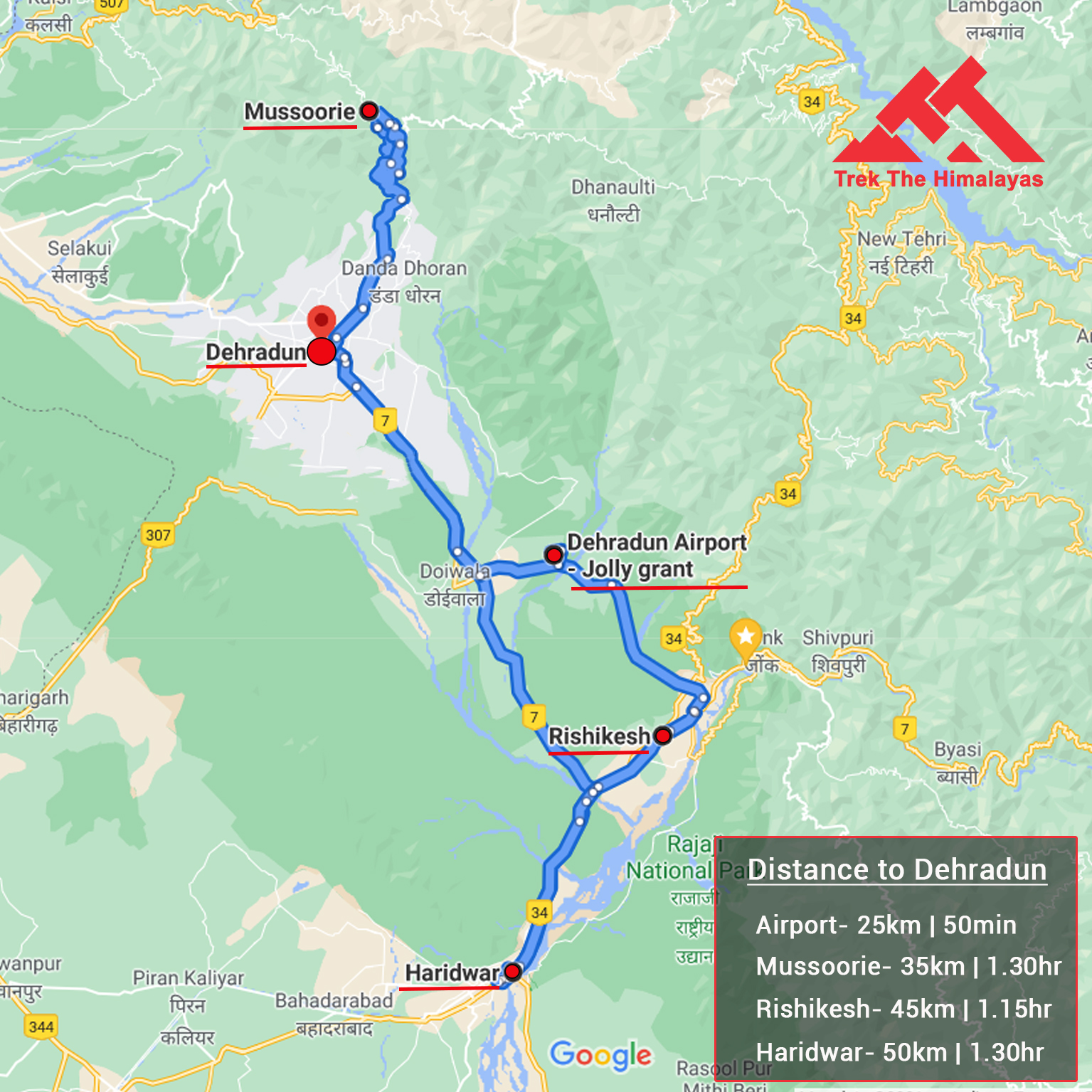
First of all everyone has to reach Dehradun
Plz Note:- Transportation Amount is not included in the trek cost.
Our pick-up location is Dehradun Railway Station at 06:00 AM
The distance from Dehradun Bus Stand (ISBT) to Railway Station is 6 km, without traffic it will take 15 minutes.
Options to reach Dehradun
1. Take an overnight train/bust to Dehradun, and then take a cab to the pickup point.
We always recommend to go for the govt. Buses over the private ones outside the bus station as based on the experience we have found that there are very high chances of delay involved with private buses. Also, govt. Buses are always more reliable. Whichever bus you choose, just make sure to reach Dehradun at least by 05:30 am positively.
2. Take flight to Dehradun airport (Jolly Grant Airport) (25 km, 50 min), if coming by flight then come one day early.
Trekkers will be dropped at Dehradun Railway station by 06:00 PM, for onward journey from Dehradun it is advised to make arrangements after 08:00 PM.
The distance from Railway Station to Dehradun Bus Stand (ISBT) is 6 km, it will take approx 25 minutes.
1. Accommodation. (Guest house, Home stay, Camping)
2. Meals while on trek (Veg.+ Egg)
3. Trek equipments: Sleeping bag, mattress, tent (twin sharing), kitchen & dinning tent, toilet tent, utensils and crampon (if required)
4. All necessary permits and entry fees
5. First aid medical kits, stretcher & oxygen cylinder
6. Mountaineering qualified & professional trek Leader, guide, cook and Support staff
7. Transport from Dehradun to Uttarkashi to Sangamchatti and return as per the itinerary
8. Mules to carry group equipment.
1. Any kind of personal expenses.
2. Food during the transit.
3. Insurance.
4. Anything not specifically mentioned under the head
5. Any kind of emergency evacuation charges
Things can be provided on demand and availability (participant has to pay extra for these things)
1- Satellite phone/setphone - is a type of mobile phone that connects via radio links via satellites orbiting the Earth instead of terrestrial cell sites like cellphones. Therefore, they can operate in most geographic locations on the Earth's surface.
2- Gamow/PAC HAPO Bag (Portable Hyperbaric Bag) - is a unique, portable hyperbaric chamber for the treatment of acute mountain sickness (AMS), also known as altitude sickness.
3- AEDs (Automated External Defibrillators) - are portable life-saving devices designed to treat people experiencing sudden cardiac arrest, a medical condition in which the heart stops beating suddenly and unexpectedly
Insurance is mandatory and can be obtained through TTH or other providers. Non-Indian rates are slightly higher, trek coordinator will share the balance payment link after booking. If you choose not to book through us, we will refund your insurance fee; email us immediately after booking for the refund.
Normally TTH expect to carry your personal luggage on your own, if you wish to offload your backpack, you can give it to Mule.
Charges of offloading backpack:-
INR 1200/- if you make an online payment, 10 days in advance
INR 1500/- if you inform us after reaching Base camp
The backpack cannot weigh more than 11 kgs. Backpack should have waterproof cover. Suitcases/strolleys/ bags will not be allowed.
The fee can be paid by online transfer/Check deposit/Cash deposit/Demand draft. Instruction for
payment will be forwarded along with your confirmation email. When your transfer is done, please
e-mail us a confirmation mail with your transfer details, so that we can follow up your reservation efficiently.
Cancellation terms:
For the cancellation of services due to any avoidable/unavoidable reasons, Trek The Himalayas must be notified of the same in writing at info@trekthehimalayas.com At the time we receive your written cancellation, refunds based on the total fare are as follows.
Cancellations prior to 25 days from the start of the Trip
Refund options
Cancellation between 24 days and 15 days to the start of the Trip
Refund options
Cancellation between 14 days and 10 days to the start of the Trip
Refund options
Cancellation less than 9 days to the start of the trek
Refund options
In the unlikely event that TTH cancels a trek prior to the scheduled departure date:
While it is extremely rare for TTH to cancel a trek, we understand that unforeseen circumstances or natural disasters may occasionally require us to do so before the scheduled departure. These circumstances could include continuous rain or snow, thunderstorms, snowstorms, landslides, floods, earthquakes, or any other natural calamity that poses a risk to the safety of our trekkers. Additionally, unforeseeable events such as local riots, curfews, pandemics, lockdowns, government orders, or any similar situations that compromise the safety of the trekking experience may also necessitate a cancellation.
In the event of such a cancellation, TTH will provide you with a voucher equivalent to the amount you paid for the trek. This voucher can be redeemed for any of our treks within the next year, allowing you to still enjoy an adventure with us at a later date.
Note
In the rare event that TTH shifts a trek:
We would like to emphasize that weather conditions in high-altitude areas are highly unpredictable and can undergo sudden changes at any time, irrespective of the day. Additionally, circumstances beyond our control, such as natural disasters, political unrest, pandemics, and lockdowns, may impact the feasibility of conducting a trek. In cases where we are unable to proceed with an event due to such circumstances that are beyond our direct control, we will make every effort to provide you with an alternative trek that is safer and more suitable.
In such situations, we will issue a voucher to offset the cost difference between the originally scheduled trek and the alternative trek. This voucher can be redeemed at any time within one year from the date of issue. Please note that a refund fee or reimbursement of the cost difference is not applicable in these cases.
Note:
Cash Voucher Terms:
Itineraries are based on information available at the time of planning and are subject to change. "Trek The Himalayas" reserves the right to change expedition dates, people or itineraries as conditions warrant. If a trip must be delayed or the itinerary changed due to bad weather, road conditions, transportation delays, government intervention, airline schedules, sickness, or other contingency for which TTH or its agents cannot make provision, the cost of delays and/or other changes are the responsibility of the participant. TTH reserves the right to decline, or accept, any individual as a trip member for any reason whatsoever.
| Back pack & rain cover | (50 - 60 ltr) with comfortable shoulder straps |
| Day pack + rain cover | 20 - 30 ltr (If hire a mule or porter) |
| Walking stick | Advisable (At least one) |
| Water bottle/Hydration pack | 2 bottles of one liter each, People who use hydration pack 1 hydration pack and 1 bottle of one liter, Carry at least one thermos flask. |
| Personal Medical Kit | Consult your doctor |
| Snacks | Energy bars, dry fruits, electral/ors |
| T-shirts | 4 Full sleeves (Non-cotton) |
| Fleece T-shirts | 1 Nos. |
| Fleece jacket | 1 Nos. (Alternative: a woollen sweater) |
| Down feather / Hollofil jacket | 1 Nos. |
| Wind & waterproof (jacket & pant) | 1 Pair |
| Thermal inners (upper and lower) | 1 Pair |
| Trek pants | 3 Synthetic (avoid shorts, fitting denims, capris) |
| Waterproof gloves | 1 Pair |
| Fleece/woolen gloves | 1 Pair |
| Poncho | 1 Nos. |
| Sunscreen cream | Moisturiser |
| Hand sanitizer | Antibacterial powder |
| Toothbrush and toothpaste | Lip balm / Chapstick |
| Toilet Paper & wipes | Quick dry towel |
| Head torch | 1 Nos. (Avoid Hand torch) |
| Sun cap | 1 Nos. (One that covers the neck as well) |
| Woolen cap | 1 Nos. |
| Balaclava | 1 Nos. (Optional) |
| Neck-gaiters | 2 Nos. |
| Sunglasses | Dark with side cover, it should be U/V protected, People who wear spectacles- (A)- Use contact lenses. (B)- Photo chromatic glasses. |
| Trekking shoes | 1 Pair (Waterproof, high ankle with good grip) |
| Floaters/flip-flops | 1 Pair |
| Cotton socks | 6 pairs |
| Woollen socks | 1 pairs |
| Gaiters | 1 Pair (TTH will Provide) |
Fitness regime for:
| Easy To Moderate |
Calculate Your BMI :
Congratulations, your body is in good conditions!
| BMI Range | Category |
|---|---|
| Less than 16.5 | Serverely Underweight |
| 16.5 - 18.5 | Underweight |
| 18.5 - 25 | Normal |
| 25 - 30 | Overweight |


Similar Treks
Uttarakhand
Duration
5 Days
Grade
Easy To Moderate
Approx
30 Km.
Altitude
12100 Ft.
Himachal Pradesh
Duration
4 Days
Grade
Easy To Moderate
Approx
25 Km.
Altitude
14000 Ft.
Uttarakhand
Duration
6 Days
Grade
Easy To Moderate
Approx
24 Km.
Altitude
12250 Ft.
Uttarakhand
Duration
6 Days
Grade
Easy To Moderate
Approx
22 Km.
Altitude
12100 Ft.
Uttarakhand
Duration
2 Days
Grade
Easy To Moderate
Approx
20 Km.
Altitude
9850 Ft.
Himachal Pradesh
Duration
5 Days
Grade
Easy To Moderate
Approx
26 Km.
Altitude
14100 Ft.
Uttarakhand
Duration
7 Days
Grade
Easy To Moderate
Approx
44 Km.
Altitude
12000 Ft.
Himachal Pradesh
Duration
3 Days
Grade
Easy To Moderate
Approx
26 Km.
Altitude
9650 Ft.
Uttarakhand
Duration
6 Days
Grade
Easy To Moderate
Approx
20 Km.
Altitude
12500 Ft.
Jammu and Kashmir
Duration
7 Days
Grade
Easy To Moderate
Approx
48 Km.
Altitude
13500 Ft.
Uttarakhand
Duration
6 Days
Grade
Easy To Moderate
Approx
37 Km.
Altitude
14100 Ft.
Uttarakhand
Duration
6 Days
Grade
Easy To Moderate
Approx
22 Km.
Altitude
12100 Ft.
Uttarakhand
Duration
6 Days
Grade
Easy To Moderate
Approx
30 Km.
Altitude
12150 Ft.
Uttarakhand
Duration
6 Days
Grade
Easy To Moderate
Approx
31 Km.
Altitude
11500 Ft.
Uttarakhand
Duration
8 Days
Grade
Easy To Moderate
Approx
44 Km.
Altitude
12500 Ft.
Jammu and Kashmir
Duration
6 Days
Grade
Easy To Moderate
Approx
40 Km.
Altitude
1140 Ft.