.webp)
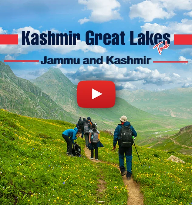
Kashmir Great Lakes Trek
Kashmir Great Lakes Trek

Region
Kashmir | India

Duration
8 Days

Max Altitude
13750 Ft.

Trekking Km
72 KM

Grade
Moderate to Difficult
Help & Support
+91 9368692892 info@trekthehimalayas.com10:00 hrs to 18:00 hrs | GMT +5:30
Monday - Saturday | Sunday Closed
17300 /Person
- July-2024
- August-2024
- September-2024
- +5% GST (goods and services tax)
- Services Sonamarg to Naranag
- Addons
-
Insurance is Mandatory.
-
Non-Indian rates are slightly higher. Trek coordinator will provide balance payment link post-booking.
- Get insurance through us or elsewhere. If not through us, email for a refund after booking.
-
Cancellation 4 or more days before the start of the trip results in a 100% cash refund.
-
Cancellation less than 4 days from the start of the trip results in no refund.
-
Transportation Srinagar to Sonamarg & retun is optional
-
Choose add-ons during booking. If missed, log in and add them later
-
Book transportation at least 10 days before the trek.
-
Cancellation 4 or more days before the start of the trip results in a 100% cash refund.
-
Cancellation less than 4 days from the start of the trip results in a 50% cash refund.
-
Cancellation after the trip date does not qualify for a refund.
-
Backpack offload is optional
-
Choose add-ons during booking. If missed, log in and add them later.
-
Book off-load at least 10 days before the trek.
-
For offline bookings at the base camp, a convenience fee of Rs. 2400 applies.
-
Cancellations made before the trip date will receive a full refund.
Insurance 280
Transport 1700
Offload 2100
For more information. Please complete this form.
Help & Support
+91 991 772 4737info@trekthehimalayas.com 10:00 hrs to 18:00 hrs | GMT +5:30
Monday - Saturday | Sunday Closed
Overview
Trek Name: Kashmir Great Lakes Trek
Days: 8
Adventure Type: Trekking
Base Camp: Sonamarg
Season:Monsoon | Autumn |
Month:July | August | September | October | November |
Country: India
Altitude: 13750 Ft.
Grade: Moderate to Difficult
Rail Head: Jammu
Stay: Camping (Twin sharing) & Hotel/Guesthouse
Food: Meals while on trek & at Hotel/Guesthouse (Veg & Eggs)
Location: Kashmir
Distance: 72 Km.
Trail Type: Cross over trail | Start in one valley, traverse the pass, and ends in another valley.
AirPort: Srinagar (sheikh ul-alam international)
Highlights:
- +5% GST (goods and services tax)
- Services Sonamarg to Naranag
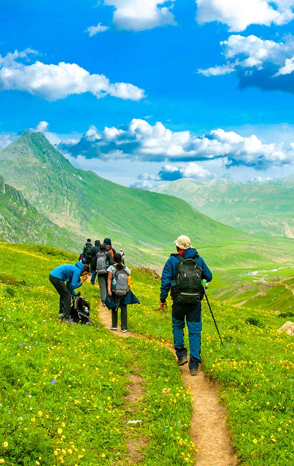
The Kashmir Great Lakes Trek is in no need of an introductory treatise. It presents the proem in itself. You can draw a preface of it by just hearing its name. Kashmir is a wonderful place and if you are on a Himalayan trek you are bound to taste the natural beauty and adventure. The trek to the Kashmir Great Lakes offers a lifetime of experience of memories that are so wonderfully reminiscent. The tranquil silence of the Kashmir lakes and their virgin beauty is spellbound. Apart from the lakes, even the barren milky snow-clad mountains stand out in might and pride.
The location of this trek is Kashmir, also known as the paradise of the earth. The trek duration is around 7-9 days and this trek is often graded as moderate in regards to the trekking challenges. The elevation circles around 13000 feet and the distance paths are approximately 63 km. On such a fulfilling trek you will learn so much learn about yourself- in a trifecta – physically, mentally, and emotionally. For a trekker, nothing can replace and prepare him for those paramount and conflicting emotions that whether his body will take so much strain and whether he will make it or not. But the joy of reaching the destination is obvious. This trek will always be happy and a cherishing trek for the trekkers that comes in handy with a few preparations.
Who Can Participate
-
Age; 15 years.
-
Experience of any high altitude trek, at least 1 treks of 4,000m/13,100ft.
-
The climber must be fit and have sufficient stamina to cover 5 km of distance in 30 minutes without stress.
-
The climber should be able to carry a 12-16 kg backpack.
-
Pulse rate at rest must be in between (60 to 90 beats per minute)
-
Blood Pressure Reading must be in between (DIASTOLIC 70 – 90, SYSTOLIC 100 - 140 mm Hg)
-
Respiratory rate at rest must be in between (12 to 20 breaths per minute)
-
Should not have Liver and kidney issues
-
Should not have Diabetes Mellitus, Bronchial Asthma, Heart problems, Hypertension etc
-
No pacemaker implant
-
People with the Sinus issues, Epilepsy please contact to trek coordinator before booking the trek
-
If your BMI is not normal, Please contact our Trek coordinator before Trek booking.
Medical & Disclaimer Form (Mandatory Documents) Click here to download Medical & Disclaimer Form
- Government Employees can avail the benefit of Special Casual Leave (SCL) when you join us for a trekking expedition. As per the rules of the Pay Commission, Special Casual Leave can be availed for up to 30 days in a calendar year for trekking/mountaineering expeditions through a registered organization. Trek The Himalayas is a registered adventure tour operator by Indian Mountaineering Foundation (IMF) and Ministry Of Tourism (MOT)
- Trekkers have to apply for leave at least 20 days before trek departure date,
- This service is exclusive to Indian government employees and is applicable only for treks within India.
- Do mail at info@trekthehimalayas to apply and mention your booked trek date and trek name.
- Junior trekkers (below 15 years) should have a company of parents/guardians.
- Trekkers between 15 to 18 years can come solo with the disclaimer form signed by parent/guardian.
- Medical & Disclaimer Form (Mandatory Documents) Click here to download Medical & Disclaimer Form
Itinerary
Arrive At Sonamarg
- Altitude: 2,400 m/ 7,800 ft
- 90 km drive from Srinagar, approx 3 hrs
- If booked in advance, TTH can arrange pickup from Nishant Garden, at 12 pm
- Our campsite is near the Sindh River (Shitkadi Village)
- Since there are no shops around ensure that you have all that you need already
- Remember to carry your ID proof in original and 2 photocopies as we have to submit them at the army check post.
The journey to Kashmir Great Lakes begins from Shitkadi Village, which is a little ahead of Sonamarg and about a 3 hr drive from Srinagar. TTH representatives will pick you up from Sonamarg and drive all the way to Shiitkadi, where you will rest for the night before beginning your trekking adventure the next day. Before you begin your trekking adventure, you will spend the day in the beautiful surroundings of Shitkadi Village. You can spot some of the great mountain peaks like Kolahoi, Tribal, Machoi, Amarnath Peak, and Machoi Glacier. The view en route to the campsite is very scenic and all along the route, you will see the vast expanse of grasslands and meadows on either side of the road. The stay is arranged at Shitkudi Campsite. There will be a briefing session in the evening before dinner. Dine early and give your body enough rest to begin your trek tomorrow.

Sonamarg To Nichinai Via Shekdur
- Altitude: 3,500 m/ 11,500 ft
- 11 km trek, approx. 8 hrs
- Altitude Gain: 1,100 m/ 3,700 ft
- After breakfast, we trek to Nichinai via Shekdur
- The trail takes you through meadows, and dense forests with Maple, Pine, and Bhoj trees.
- After approx. half an hour, we get to an army check post where we have to submit our ID proofs
- While you are at it, you can enjoy an awesome view of the Sonmarg Valley or the Thajiwas Glacier
- The trek from Shitkadi to Shekdur goes through thick forests of pine trees and will take approx. 2 and half hours
- At Shekdur, you can indulge in instant noodles and an omelette if you wish to
- We follow the Nichinai stream as we trek from Shekdur to Nichinai
- We have lunch at the Nichinai stream.
3 hours ascent followed by 1 hr descent and finally a gentle ascent to Nichinai (6 hrs, 9 km).
The trek starts 3 km out of Sonamarg, on Srinagar Road. Exactly at the 3 km mark, spot a lone Dhaba on the right. The place also sells packaged water, biscuits, etc., and is your last place to pick up any snacks or little bites. The next trace of civilization can be spotted at Naranang after the trek.
A jeep track diverts to the right off the main road at the shop. The track goes down to the level of the Sindh River that flows in between the mud track and the main road. The trekking trail starts along the track but quickly diverts higher up. 10 minutes into the trek, the trail bends and enters a green meadow. The meadow directly overlooks Sonamarg town. In half an hour, you reach the top of the meadow from where tree lines of Maple and Pine start. Once you reach the tree line, the trail descends until a tiny brook and then climbs up again and what follows next is a lovely dense forest of Maple trees. Walking on green beds of grass amidst the Maple cover is an experience unique to Kashmir in India.
For the next hour and a half, the trail winds up through Maple trees. Stick to the trail that goes in an uphill direction as the one heading down diverts into the nearby villages. Occasionally, the trees give way to clearings. Turn around and delight in the spectacular view of the Sonamarg Valley that gets bigger and fuller as you keep gaining altitude. The Maple cover accompanies you to the top of the ridge and on one side a meadow gently slopes down. Spend a few moments on the ridge, enjoying the view of Sonamarg and the neighbouring Valley. The streams, the meadows, the pines, and the towns nestled together make a wonderful picture. The climb now gradually goes downhill as the trail slopes down towards the meadow that is lined with Silver Birch trees and a few shepherd huts. The carpet of green rolls down from the treeline all the way to the end of the 40 ft wide meadow. There are a couple of small brooks that cross the meadow, which can be your source of water. On your right, you can see a small group of peaks covered in snow. You are now in Shekdur. If you wish to keep your trek short for the day, you can also opt for pitching your tent here. From the road head, it takes 2 1/2 hours to reach Shekdur meadows, it will take about half an hour more if you decide to end your trek at the edge of the meadow.
The Shekdur Campsite is surrounded by Bhoj trees on all sides and this is the single such campsite that has tree covers thus this is a good spot to take some Instagram-worthy photographs. If you have started from Srinagar in the morning, make Shekdur your first camp. The next campsite Nichinai is at least 2 more hours away.
If you started from Sonamarg then Shekdur is just three hours away which makes it too early to camp. Having lunch at Shekdur campsite head to Nichinai campsite. The meadows of Shekdur stretch for half an hour. The gentle descent of the meadow now ends in forests of Bhoj or Silver Birch. Take the trail that goes in the middle of the forest and continue to descend gently. Watch out for sun rays making their way in between the thick foliage making it a nice show of light and dark.
In 45 minutes, you reach the end of the Birch trees and the trail goes down and climbs back into a river valley. The River Valley is the beginning of Nichinai. The trail is now along the right bank of the river going upstream. Look behind to see the snow-clad peaks of the Sonmarg Valley. You are now in a wide valley enclosed by mountains on either side. The river, which joins the Sindh eventually flows with speed through the valley. The first 30 minutes is over rocks and if you are taking mules, they will walk very slowly over here.
An hour more into the river valley, green patches devoid of rocks open up. The river valley widens and you can see the green meadow widening in between the two mountain ranges. Far ahead lie triangular twin snow-clad peaks. At Nichinai campsite, find a clear spot to pitch your tents, ending the first day of the trek.

Nichinai To Vishansar Lake
- Altitude: 3,650 m/ 12,000 ft via 4,000 m/ 13,100 ft
- Distance: 12 km | Duration: 7 hr
- Trek from Nichinai to Nichinai Pass is approximate 1 and half hours accent. At the top of Nichinai Pass, you can get the BSNL network, which is the last point under the mobile coverage area.
- From Nichinai Pass to Vishansar there is a descent
- At Vishansar campsite lunch will be offered.
- We can visit the Vishansar Lake, which is just 15 minutes walk from the campsite
- The first lake of the trek and one of the most beautiful ones
- If the trek is in July, the lake will be frozen. Otherwise, we can go fishing at the lake, with the permission from Srinagar fishing department.
- Vishansar is visited by hoards of sheep and their shepherds who always have some interesting stories to tell.
- A campsite is a unique place with open ground and you can play volleyball, cricket, etc.
- Beware of dogs at the campsite.
Moderate climb to Nichinai Pass (13,000 ft). Small descent followed by a long flat meadow walk ending near Vishansar Lake (12 km, 6 hrs).
We start the day early around 7 or 8 in the morning to begin our trek towards the first of the Great Lakes, the Vishansar Lake. The day's trek is more or less a long walk on the alpine grasslands of Kashmir. Start your trek from Nichinai to Nichinai Pass, which is visible from the campsite. Half an hour into the walk and you have to cross the gurgling stream to reach its left bank. The trail starts ascending here and for the next one hour, you will climb up gradually to the Nichinai Pass. The Nichinai Pass is the highest point in today’s trek and is located at an altitude of 13,500 ft. From the pass, it’s a small descent and then a flat walk on the meadow all the way to the Vishansar Lake.
As you continue climbing the Pass, you will see the lake down below at the foot of the mountains, it appears to be a small deep-blue enclosure. The trail that you are walking on now is not the original ridge and it will turn inwards two times before you arrive at the Nichinai Pass. The Nichinai Pass is like a big tunnel and from the top, you can observe the Sonamarg Valley down below. BSNL network is erratic here and this is the last point where you will get any network. The next traces of the network are available when you have moved past Gangabal. On the left of the pass lies the mighty peaks of the Himalayan region, whereas on the right side, there are no mountains but the ground rises up. While some may find the climb to the Nichnai Pass a little strenuous as it is a straight climb, however, there is good news as the trek post the pass is a downward climb. The trail from the pass descends rapidly and in about an hour, you will reach grassy lands from the rocky area. The meadow is a vast expanse of land spreading far and wide with snow-clad mountains surrounding the entire meadow. There’s another river flowing from the pass into the meadow ahead. To your left, you will also see a big waterfall cascading down and mingling with the river. As you walk on the meadows, you will notice two streams crossing the meadows, stick to the banks of the one on the left, and in about half an hour, you will have to make a stream crossing but be prepared as the water is going to be icy cold.
At the end of the valley, a river flows perpendicularly from left to right and this river actually originates at the Vishansar Lake. The lake is not visible yet as it is a little higher on the top. This is a good place to pitch your tents by the river. After the trek, if you have ample time, you can explore the twin lakes or wait for it until the 6th day. From your campsite, the Vishansar Lake may be about 0.5 km away and about 100 ft high. The Vshnusar Lake is nestled beautifully between 4 mountains and the Kishansar Lake beautifully reflects in the lake waters. The colour of the lake changes according to the time of the day and the cloud cover. Before sunrise, the lake is usually colourless and on a clear day, as the sun rises, the water of the lake starts getting blue on a sunny day, the water of the lake is a deep aquamarine blue. As the sun gets closer to setting, towards the end of the day and it becomes a greenish-blue towards the end of the day. This is the first lake you will see on the trek and eventually, you will check other lakes as well. Today we will camp close to Vishansar Lake.

Acclimatization + Rest Day (Conditions Apply)
Day 4 is reserved for acclimatization as you need to give your body enough time to adjust to the conditions of higher altitude. The next lake following the Vishansar lake is the Kishansar Lake. Kishansar is 0.5 km away from Vishansar and is situated at the base of the Kishansar Peak. It will take about 45 minutes to trek to Kishansar from Vishansar. You can take a short acclimatization walk to Krishansar Lake for acclimatization purposes. The trail to the Kishansar Lake climbs from the right side of the Vishansar Lake. On the right-hand side of the Kishansar Lake lies a big meadow which is a perfect spot for capturing photographs.
Note: The use of acclimatization day is subject to change to weather conditions. If the weather is really good then we won't stop for acclimatization but rather move forward to the next campsite. Acclimatization day can be used layer at Gangabal campsite.

Vishansar Lake To Gadsar Lake Via Gadsar Pass
- Altitude: 3,650 m/ 12,000 ft via 4,200 m/ 13,750 ft
- 14 km trek, approx. 10 hrs
- We start the trek earlier than usual
- The trail passes from Vishansar To Gadsar via Gadsar Pass, the highest point of the trek.
- From Vishansar, the trail takes a steep ascent till Gadsar Pass
- We can spot the Kishansar Lake on the way
- From the Gadasr Pas till the campsite, we descend gradually
- We can spot the Gadsar Lake en route
- You might also spot the glacier of the Gadsar Lake
- After the Gadsar Lake, we will reach the campsite in two hours
- Just a few minutes before our campsite, we will have another army checkpoint and we will have to share our IDs
- Packed lunch will be provided during the trek
Steep 2 hours ascent followed by a steep descent following a gentle walk in the meadows (5 hrs, 10 km)
Today we will trek to Kishansar Lake via Gadsar Pass. From your campsite, you can spot a very thin line travelling through the side of the mountain, this is the trail that you need to follow today. A climb of about an hour and a half will take you to the top of a ridge, another 45 minutes in the climb and you will arrive at a spot that will totally captivate you with an amazing view. There comes a point from which you can see the Kishansar and Vishansar Lakes together in full view. This enchanting view accompanies you all the way to the top of the Gadsar Pass. The Gadsar Pass lies at an altitude of 13,750 ft and is the highest point on today’s trek. Relish the view from the top of the Gadsar Pass for a while before moving ahead. On the horizon line on one side are the snow-clad majesties of the Himalayas and on the other side, a gorgeous valley stretches with 2-3 small lakes visible from the top. The peaks that you can see from the top of Gadsar Pass lie out of the Line Of Control (LOC).
Once you reach the Gadsar Pass, it is a steep descent below and en route, you will first spot the Yamsar Lake, a quaint little lake not very popular among the people. Yamsar Lake can serve as the first landmark that takes you to Kishansar Lake. Continue from Yamsar and about an hour of descent will bring you again to flat grasslands or meadows of the beautiful Kashmir Valley. This time the valley is a bit narrower, the mountains surrounding the meadow on either side. Multi-colored flowers line the green grass of the valley and give it an ethereal look. Once you have arrived at the area near the blue Irises, Gadsar is not far away. Soon you will reach Gadsar, one of the prettiest alpine lakes you have ever seen. Gadsar Lake lies at an altitude of 12,000 ft and the sheer beauty of it will leave you speechless. Gadsar is located at the base of mighty snow-covered peaks. On the one side, you will see snow blocks cascading down to the lake from the mountains, and on the other side, you can see colorful flowers and greenery making for a mesmerizing sight.
Gadsar Lake area will be our campsite for the day, although not many people camp here. If you are camping near Gadsar, make sure that you leave the campsite as clean as you found it. If you do not opt for camping by the lake then continue your climb further downhill to the Gadsar army camp. About half an hour into the trek, the narrow valley opens up and becomes wider, you can see another blue lake on the left-hand side of the valley. As you move on, you are losing a considerable amount of altitude. Continue for another half an hour and you will start noticing the Shepherd huts lining the edge of the valley, keep walking and after about half an hour you will arrive at the army camp. The army camp is a small hut that houses 5-8 army men and to move further beyond the camp, you will have to obtain permits from the army headquarters. The headquarter is located three miles from the checkpoint, follow the tree line into the village to find the HQ. The Gadsar army camp communicates with walkie talkie and the HQ is equipped with a satellite phone. A pro tip: When you are near the army camp, report as quickly as possible as it takes about 2 to 3 hours for the green signal to come through from the headquarters. Your ID proofs will be checked, collected, and recorded before you can proceed further.

Gadsar To Satsar
- Altitude: 3,650 m/ 12000 ft
- Distance: 9 km | Duration: 6 hrs
- Mid-July to mid-August, the trail is laden with vibrant flowers
- We need to share our IDs at another army check post en route
- Moving on, we see two small lakes which are often mistaken for Satsar Lakes
- We will visit Satsar twin lakes in the afternoon, which are approx. 1.3 hr apart
- Satsar Twin Lake is also known as Mengen Top
- The twin lakes are situated in the middle of two mountains.
Gentle descent or 1 hr followed by a steep ascent for 3 hrs followed by a flat meadow walk (6 hrs, 12 km)
From the army camp, move left towards the stream, to head up into the mountain. You are now above the tree line and you can see the tree cover and the rivers below you. The climb continues for an hour and a half and you gain an altitude of 1,100 ft. Once you cross past the 11,500 ft mark, the climb transforms into a traverse and bends towards the left leaving the river valley. Once you are out of the river valley, you will be walking on a flat meadow surrounded by mountains on all sides. This section of the trail is called Maegandob and you may also spot a few craters to your right. Soon you will spot first of the Satsar Lakes. The name Satsar translates to ‘Sat’ meaning seven and ‘Sar’ meaning lake. Satsar is a collection of seven lakes which justifies the significance of the name.
If Gadsar Lake was your last camping spot, you can choose to camp here. However, if you camped in the army camp then it is justifiable that you trek a little further and camp near one of the Satsar Lakes. Out of all the lakes, you may find 4 to 5 lakes with water, depending on the season you are visiting Kashmir in. Once you cross the bridge, you will come across another army check post, this will be the third check post on your route, and the same process of checking, collecting, and recording your ID and information will continue. After the procedures are done, you can continue on your trail and after 10 minutes of walking, you will arrive at the first of the Sat Sar lakes. The lake is set in a picturesque setting with lush greenery and mountain views, and the emerald-blue color of the lake changes hues with time.
Satsar Lake is our camping ground for the day. Find an ideal spot for camping near the lake and pitch your tents. Retire early in your tents and give your body the rest it deserves after a long day of hiking.

Satsar To Gangabal Twin Lakes Via Zaj Pass
- Altitude: 3,500 m/ 11,500 ft via 3,950 m/ 13,000 ft
- Distance: 11 km | Duration: 6 hours approx.
- We walk on rocky paths for approximately an hour and ascend to Jazz Pass
- At the Pass, you can enjoy views of the 4 lakes as well as Mt. Harmukh and its glacier.
- From the pass, we descend till Gangabal Lake and camp at Nandkol Lake
- We visit the Gangabl Lake, which is one of the largest lakes on the trek.
Mild ascent followed by a gradual descent followed by long steep ascent long steep descent followed by gradual up and down walk. (6 hours, 9 km)
The trail follows the same pattern of going up and down. From our campsite, we will begin our trek and after half an hour of climbing, you will arrive at the biggest of the Satsar Lakes and also the last one in the sequence. The terrain is mostly rocky and filled with boulders. From the lake, the trail keeps descending and continues for about half an hour on this trail and you will arrive at the first forest line. On your right is a ridge and on your left is the forest line. From here, you will again gain altitude through a zig-zag trail to the top of the first ridge you have to climb two more ridges to reach the top and the terrain from the base to the ridge top is barren and rocky. On the opposite side, you can spot some Gujjar huts and some greenery that is in stark contrast to the barrenness of the trail you are on.
An ascent of about two hours will bring you to the top of the third ridge, which is approximately 13,000 ft. From the top of the ridge, you get an amazing view of two lakes with the stream taking water from the higher lake to the lower, which is one of the most wonderful sights to behold. Look more closely and you will see two more lakes on either side, the name of the smaller lake is not known while the biggest lake amidst all of them is Gangabal with its companion Nandkol. The route descends and ascends as you climb down about 1,400 ft to the lake.
There are no water sources on the ascent, during the descent, you will come across a stream, and crossing the wooden bridge, you will arrive at Nandkol your camping site for the night. Nandkol campsite is a popular camping ground and as such a Green Trails Hotspot. You can spot remnants of camping here and there. A lot of people come from Naranang to Gangbal for a weekend outing and that leaves the places with a good deal of waste. Nandkol and Gangbal are also famous fishing destinations, especially trout fish. The Gangbal Lake is at a distance of 20 minutes from Nandkol and a stream connects both of them. We have to cross the stream to reach one lake from the other. Avoid crossing the stream from the lower level, instead, go all the way to Gangbal and you will find a bridge laid out. Gangbal Lake is a big one and circling it will take at least an hour.

Gangabal To Naranag, Drive To Srinagar
- Altitude: 2,250 m/ 7,450 ft
- Distance: 15 km | Duration: 7 hrs approx.
- The trail is a descent till the last point of the trek - Naranang, so take care of your knees and ankles.
- The trail will pass through pine tree forests
- On advance booking, TTH can arrange transport to Srinagar at a charge
Gradual descent followed by steep descent (6 hrs, 11 km)
Although today is a complete downhill climb the steep descent is going to be hard on your knees so be prepared. From your Gangabal campsite, climb down through the ridge following the stream towards the tree covers. 30 minutes into the trek and the airtel network begins to catch network, you can inform your home that you have made it down safely! As the ridge ends, you arrive at a flat meadow. From here you can look back and see an impressive image of Harmukh Peak, standing tall and mighty.
An hour into the trek and you will begin to enter the treeline, which mostly consists of Pine trees and you will also begin to see signs of civilization as a log hut comes into view. For about 6 km you will keep making your way in and out of the forest not really losing much altitude. After two-thirds of the distance is covered, the trail begins to descend and it is a really steep descent. The trail here is muddy and well-trodden and through thick pine covers. The last 4 km of the trek is a huge drop where you lose an altitude of more than 3000 ft. You may even spot a lot of trekkers on your way down, they are trekking from Naranang to Gangabal. Naranang slowly comes into sight, a little bit more to go. The last part can be a test of your endurance as it is quite steep. A little further and stone-paved path comes along and in a few minutes, you enter the village of Naranang. From here, you will drive to Srinagar. Expect to reach Srinagar by 6:30 pm. From here on you can book your further travel ahead.

Day-1: Arrive At Sonamarg
- Altitude: 2,400 m/ 7,800 ft.
- 90 km drive from Srinagar, approx 3 hrs.
Day-2: Sonamarg To Nichinai Via Shekdur
- Altitude: 3,500 m/ 11,500 ft.
- 11 km trek, approx. 8 hrs.
- Altitude Gain: 1,100 m/ 3,700 ft.
Day-3: Nichinai To Vishansar Lake
- Altitude: 3,650 m/ 12,000 ft via 4,000 m/ 13,100 ft.
- Distance: 12 km | Duration: 7 hr.
Day-4: Acclimatization + Rest Day (Conditions Apply)
- You may visit Kishansar Lake, which is approximately 1 and half km from our camp site.
- If weather is not good we will use acclimatization day at Vishansar or else move towards our next camp site, rest day can be used at Gangbal camp site.
Day-5: Vishansar Lake To Gadsar Lake Via Gadsar Pass
- Altitude: 3,650 m/ 12,000 ft via 4,200 m/ 13,750 ft.
- 14 km trek, approx. 10 hrs.
Day-6: Gadsar To Satsar
- Altitude: 3,650 m/ 12000 ft.
- Distance: 9 km | Duration: 6 hrs.
Day-7: Satsar To Gangabal Twin Lakes Via Zaj Pass
- Altitude: 3,500 m/ 11,500 ft via 3,950 m/ 13,000 ft.
- Distance: 11 km | Duration: 6 hours approx.
Day-8: Gangabal To Naranag, Drive To Srinagar
- Altitude: 2,250 m/ 7,450 ft.
- Distance: 15 km | Duration: 7 hrs approx.
* Please Note that prepaid sim cards do not work in Kashmir
Don’t forget your ID proof in original and 2 photocopies
On Day 8, you’ll reach Srinagar between 6:30 pm and 7:30 pm. You can book your travel any time after 8 pm
Important Links
Medical & Disclaimer Form (Mandatory Documents) Click Here.
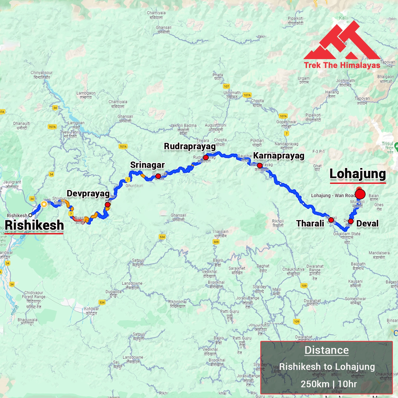
How To Reach
It is essential for everyone to arrive at Srinagar (11:00 am)
Pick-up location: Nishant Garden in Srinagar
Once you have reached Srinagar, TTH will manage the rest of your travel arrangements, if you have opted for TTH's pick-up service, you can select this option during the booking process by adding it as an add-on.
Do reach Srinagar one day before your trek date for a safer side.
Pick-up Place & Time : Nishant Garden 12:00 PM – 1:00 PM
Options to Reach Srinagar:
1. If you are planning to take a bus, you can reach the bus stand in Srinagar from any major city. It will take approx. 30 minutes to reach Nishant Garden from the bus stand.
2. If you are planning to fly to Srinagar which is well connected to all major airports in India, you can reach Nishant Garden in 45 to 60 minutes via taxi from the airport (approx 20 Km).
3. If you’re coming by train, there are two railway stations.
- Jammu railway station is about 260 km away and takes around 8 hours by bus.
- Udhampur is 200 km away and from there it is a 6 hours bus journey to Srinagar.
If you prefer to travel independently, you can either take a government bus or book a private cab. Your trek coordinator will provide guidance on how to arrange for the bus or cab booking.
Arrive in Rishikesh by 6:00 pm.
The designated drop-off point is Nishant Garden.
If you have to make any arrangements for further travel from Srinagar, do it the next day.
TTH offers comfortable transportation through Tempo Traveler, Bolero, or equivalent vehicles. If you wish to upgrade your mode of transportation, please contact your trek coordinator for further assistance.
Cost Terms
Inclusion
1. Insurance is Mandatory.
2. Accommodation (as per the itinerary):
- Camping while the trek (Twin sharing basis).
3. Meals (Veg + Egg):
- Meals while on trek (Veg & Egg).
4. Support:
- 1 Versatile base camp manager: handles communication and deploys extra manpower in emergencies.
- 1 Mountaineering & First aid qualified professional trek Leader.
- 1 Experienced high altitude chef.
- Local experienced guides (Number of guides depending on the group size).
- Enough support staff.
5. Trek equipment:
- Sleeping bag, Sleeping liners (if required), Mattress, Utensils.
- 3 men all season trekker tent (twin sharing), Kitchen & Dining tent, Toilet tent.
- Camping stool, Walkie talkie.
- Ropes, Helmet, Ice axe, Harness, Gaiters & Crampon (if required).
6. First aid:
- Medical kit, Stretcher, Oxygen cylinder, Blood pressure monitor, Oximeter, Stethoscope.
7. Transportation (as per the itinerary):
- Transport from Srinagar to Sonmarg and Narnag to Srinagar (Rs1,700).
8. Mules/porters to carry the central luggage.
9. Clock room facility available at the base camp for additional luggage.
10. All necessary permits and entry fees, Upto the amount charged for Indian.
11. Services from Sonamarg to Naranga.
Exclusion
1. Food during the transit.
2. Any kind of personal expenses.
3. Mule or porter to carry personal luggage.
4. Emergency evacuation, hospitalization charge or etc.
5. Anything not specifically mentioned under the head Inclusion.
Things can be provided on demand and availability (participant has to pay extra for these things).
1- Satellite phone/set phone - is a type of mobile phone that connects via radio links via satellites orbiting the Earth instead of terrestrial cell sites like cellphones. Therefore, they can operate in most geographic locations on the Earth's surface.
2- Gamow/PAC HAPO Bag (Portable Hyperbaric Bag) - is a unique, portable hyperbaric chamber for the treatment of acute mountain sickness (AMS), also known as altitude sickness.
3- AEDs (Automated External Defibrillators) - are portable life-saving devices designed to treat people experiencing sudden cardiac arrest, a medical condition in which the heart stops beating suddenly and unexpectedly.
Cancellation terms:
Cancellations prior to 25 days from the start of the Trip
Refund options
- 5% deduction of trek fee
- 100% cash voucher for any trip till one year
- Transfer your trek (any trek, any date) to your friend
Cancellation between 24 days and 15 days to the start of the Trip
Refund options
- 30% deduction of trek fee
- 100% cash voucher for same trip till one year
- 85% cash voucher for any trip till one year
- Transfer your trek (same trek, any date) to your friend
Cancellation between 14 days and 10 days to the start of the Trip
Refund options
- 50% deduction of trek fee
- 80% cash voucher for same trip till one year
- 70% cash voucher for any trip till one year
- Book the same trek, in the same season, with any other batch
- Transfer your trek (same trek, any date) to your friend
Cancellation less than 9 days to the start of the trek
Refund options
- No cash refund
- 20% cash voucher for the same trip till one year
- 10% cash voucher for any trip till one year
- Transfer your trek (same trek, same date) to your friend
Note- If a booking is made using a voucher or discount code, the policies related to vouchers and discounts cannot be modified.
In the unlikely event that TTH cancels a trek prior to the scheduled departure date:
While it is extremely rare for TTH to cancel a trek, we understand that unforeseen circumstances or natural disasters may occasionally require us to do so before the scheduled departure. These circumstances could include continuous rain or snow, thunderstorms, snowstorms, landslides, floods, earthquakes, or any other natural calamity that poses a risk to the safety of our trekkers. Additionally, unforeseeable events such as local riots, curfews, pandemics, lockdowns, government orders, or any similar situations that compromise the safety of the trekking experience may also necessitate a cancellation.
In the event of such a cancellation, TTH will provide you with a voucher equivalent to the amount you paid for the trek. This voucher can be redeemed for any of our treks within the next year, allowing you to still enjoy an adventure with us at a later date.
Note
-
The issuance of a voucher is not applicable in situations where you are required to descend from the trek for any reason. The trek leader may make the decision to send you down from the trek due to factors such as insufficient fitness level, symptoms of Acute Mountain Sickness (AMS), high blood pressure, exceeding the designated turn-around-time, health concerns, or if you are found smoking, drinking, or violating the rules set for the trek. In such cases, the provision of a voucher does not apply.
In the rare event that TTH shifts a trek:
We would like to emphasize that weather conditions in high-altitude areas are highly unpredictable and can undergo sudden changes at any time, irrespective of the day. Additionally, circumstances beyond our control, such as natural disasters, political unrest, pandemics, and lockdowns, may impact the feasibility of conducting a trek. In cases where we are unable to proceed with an event due to such circumstances that are beyond our direct control, we will make every effort to provide you with an alternative trek that is safer and more suitable.
In such situations, we will issue a voucher to offset the cost difference between the originally scheduled trek and the alternative trek. This voucher can be redeemed at any time within one year from the date of issue. Please note that a refund fee or reimbursement of the cost difference is not applicable in these cases.
Note:
- Change of trek batch is dependent on the availability of seats in the batch
- In case of transferring a trek to a friend, he/she should satisfy all the mandatory requirements put forward by TTH
- TTH holds the right to change/cancel the policies, without prior notice
- Cash refund is applicable only in case of bookings made without using any promotional offer code or vouchers
Cash Voucher Terms:
- This is a non-transferable voucher
- The voucher cannot be merged with any other offer of Trek The Himalayas
- The voucher is valid for Trek booked directly with Trek The Himalayas in India
- To avail the voucher please use your register phone number or e-mail id
- All the other Terms of booking a trek with Trek The Himalayas are applicable to the voucher
- Trek The Himalayas holds rights to add/remove any of the Terms and Conditions without prior notice
Itineraries are based on information available at the time of planning and are subject to change. "Trek The Himalayas" reserves the right to change expedition dates, people or itineraries as conditions warrant. If a trip must be delayed or the itinerary changed due to bad weather, road conditions, transportation delays, government intervention, airline schedules, sickness, or other contingency for which TTH or its agents cannot make provision, the cost of delays and/or other changes are the responsibility of the participant. TTH reserves the right to decline, or accept, any individual as a trip member for any reason whatsoever.
Trek Essentials
PDF Of Trek Essential Download
| Backpack with rain cover | (50 - 60 ltr) with comfortable shoulder straps |
| Day pack with rain cover | 20 - 30 ltr (If off-load opted) |
| Walking stick | Advisable (At least one) |
| Water Bottle / Hydration pack | 2 bottles of one liter each, People who use hydration pack 1 hydration pack and 1 bottle of one liter. |
| Small size tiffin/lunch box | 1 Nos |
| Snacks | Energy bars, dry fruits, electoral/ors |
| Personal Medical Kit | Consult your doctor |
| T-Shirt (Synthetic quick dry) | 2 Full & 2 Half sleeves |
| Fleece T-shirt | 1 Nos |
| Wind stopper / Fleece jacket | 1 Nos |
| Windproof Jacket | 1 Nos |
| Down feather / Hollow jacket | 1 Nos |
| Thermal inner (Upper and Lower) | 1 Pair |
| Trek Pant (Synthetic quick dry) | 3 Nos |
| Wind stopper / Fleece Pant | Not required |
| Waterproof gloves | Not required |
| Fleece / woollen gloves | 1 Pair |
| Poncho / waterproof Jacket and pant | 1 Nos |
| Sunscreen | 1 Nos |
| Moisturiser | 1 Nos |
| Chap-stick / Lip balm | 1 Nos |
| Toothbrush and toothpaste | 1 Nos |
| Toilet paper & Wipes | 1 Nos |
| Soap / hand sanitizers | 1 Nos |
| Antibacterial powder | 1 Nos |
| Quick dry towel | 1 Nos |
| Head torch | 1 Nos. (Avoid Hand torch) |
| Sun Cap | Not required |
| Woolen cap | 1 Nos. |
| Balaclava | Not required |
| Buff / Neck-gaiters | 2 Synthetic |
| Sunglasses | UV with dark side cover, People who wear spectacles - (A)- Use contact lenses | (B)- Photo chromatic glasses |
| Trekking shoes | 1 Pair (Waterproof, high ankle, good grip) |
| Floaters / flip-flops | 1 Pair |
| Cotton socks | 7 pairs |
| Woollen socks | 1 pairs |
| Gaiters | 1 Pair (TTH provides when required) |
| Micro spikes | 1 Pair (TTH provides when required) |

Frequently Asked Questions(FAQ)
To register with TTH, visit our website - www.trekthehimalayas.com and create your account. To create your account you will need to use your email address and fill in all the details, set your unique password and your account is ready to use.
- To book a trek with TTH, you first need to register with us and create an account.
- Choose the trek that you want to do and click on available dates.
- You will land at the login page, fill in the required details.
- Add Participants, choose add-on services click on the Pay now button, choose your preferred payment method, and make the payment. TTH accepts multiple payment options, including credit/debit cards, net banking, and UPI.
- You will receive a confirmation email from TTH with all the necessary details about the trek, including the meeting point, transportation, accommodation, and other important instructions.
please send an email to us at info@trekthehimalayas.com or reach out to the numbers provided in the Help and Support section of your Trek Page. We will ensure that your issue is promptly resolved.
To book services such as off-load luggage and transportation, you can find them listed as add-ons. These additional services can be booked at the time of your initial booking. If you miss booking add-ons during the initial reservation, you can log in anytime and easily book 4 days before the departure date add-ons through the platform.
In such a situation, please log in to your account and transfer your trek or date to the desired one within 12 hours or drop us an email at info@trekthehimalayas.com 10 days before the departure date of the trek. After the initial 12-hour period, any changes will be processed according to the cancellation policy.
We recommend visiting our "Suggest Me a Trek" page. By filling out the form, our experts will contact you with the best possible trek options based on your preferences and experience level. Alternatively, you can reach out to us via email at info@trekthehimalayas.com or give us a call using the numbers provided on our website for personalized assistance and recommendations.
Family treks differ from regular treks by focusing on ease of difficulty, offering shorter durations for younger participants, Kid-friendly and easily digestible foods, child-friendly activities, maintaining a higher guide ratio for diverse age groups, and implementing additional safety measures for families.
Family Trek with Kids recommendation Only Dayara Bugyal and Chopta Chandrashila Trek.
Minimum age for TTH treks is typically 7 years, though this may vary depending on the specific trek.
Yes, you can take a kids to a high-altitude trek with a parent. Discuss with a trek expert before booking a trek.
Junior trekkers (below 15 years) should have a company of parents/guardians.
Trekkers between 15 to 18 years can come solo with the disclaimer form signed by parent/guardian.
Medical & Disclaimer Form (Mandatory Documents) Click here to download medical and disclaimer form
Physical Fitness: Ensure your child is physically fit. Engage them in regular exercise, outdoor activities, and hikes to build stamina and endurance. Hydration: Emphasize the importance of staying hydrated at high altitudes. Encourage your child to drink water regularly, even if they don't feel thirsty. Proper Nutrition: Provide a well-balanced diet with sufficient carbohydrates for energy and foods rich in iron to prevent altitude sickness. Adequate Sleep: Ensure your child gets enough sleep in the days leading up to the trek. Quality rest is crucial for altitude adaptation. Educate on Altitude Sickness: Teach your child about the symptoms of altitude sickness, such as headache, nausea, and dizziness. Encourage them to communicate any discomfort immediately. Appropriate Clothing and Gear: Dress your child in layers to adjust to changing temperatures. Ensure they have appropriate trekking gear, including sturdy footwear. Positive Mindset: Foster a positive mindset. Encourage your child, and let them know it's okay to take breaks when needed. Medical Check-Up: Schedule a medical check-up before the trek to ensure your child is fit for high-altitude activities. Consult with a healthcare professional about any potential health concerns.
TTH takes special care to provide wholesome and nutritious food for children on treks. Here are some of the foods that are typically served for children:
Breakfast: For breakfast, TTH serves a variety of options like porridge, cornflakes, bread, butter, jam, honey, boiled eggs, omelettes, and pancakes. Children can choose from these options to fuel themselves for the day's trek.
Lunch: For lunch, TTH serves lunch which includes rotis, vegetables, rice, dal, and salad. The rotis are usually made fresh on the trek and are a good source of carbohydrates. The dal and vegetables provide protein and other essential nutrients.
Snacks: TTH provides healthy snacks like fresh fruits, dry fruits, energy bars, cookies, and biscuits to keep the children energized throughout the day.
Dinner: For dinner, TTH serves a hot and wholesome meal which includes soup, rice, dal, vegetables, and a non-vegetarian dish (if requested in advance). Children can also choose from a variety of desserts like custard, jelly, and fruit salad.
Dietary requirements: If a child has any special dietary requirements, TTH can cater to those needs as well. For example, if a child is lactose intolerant or allergic to nuts, the kitchen staff can make arrangements to accommodate those requirements.
Choosing the right trek for a beginner can be a bit overwhelming as there are many factors to consider such as distance, elevation gain, terrain difficulty, weather, and time of year. Here are some tips that can help you choose the right trek for a beginner:
1. Determine fitness level: Assess the fitness level of the beginner to understand their physical capabilities. This will help you select a trek that is challenging but not too difficult.
2. Choose a well-traveled trail: A well-traveled trail will have more amenities such as signposts, water stations, and shelter. It is also safer as there will be other hikers on the trail.
3. Consider the length of the trek: For beginners, it is recommended to start with a shorter trek that can be completed in a day or two. This will help them get acclimatized to trekking and build their confidence.
4. Look for gradual elevation gain: Choose a trek with a gradual elevation gain rather than steep ascents. This will make the trek easier and more enjoyable.
5. Check the weather: Check the weather forecast before selecting a trek. Avoid treks during the monsoon season or winter when the trails can be slippery or dangerous.
6. Research the trail: Read about the trail to get an idea of the terrain, altitude, and difficulty level. This will help you select a trek that is suitable for the beginner.
7. Consult with an expert: If you are unsure about which trek to choose, consult our trek expert Mr. Nitin (+91 70600 59773) between 10 AM to 6 PM (Tuesday - Friday). Mr. Nitin will provide you valuable advice and guidance.
Overall, it is important to choose a trek that is enjoyable, challenging but not too difficult, and suitable for the beginner's fitness level and experience.
It is not recommended for a beginner to choose a difficult Himalayan trek. Trekking in the Himalayas can be physically and mentally challenging, especially if you are not used to the high altitude, steep slopes, and rugged terrain. Choosing a difficult trek without the proper experience, fitness level, and preparation can be dangerous and put you at risk of altitude sickness, injury, and other hazards.
If you are a beginner, it is recommended to start with an easier trek and gradually build up your skills and experience. This will help you understand the challenges of trekking in the Himalayas, and also prepare you physically and mentally for a more difficult trek in the future. It is also important to choose a trek that matches your fitness level, experience, and interest.
There is no specific age limit for a beginner trekker. However, it is important to consider your physical fitness, health condition, and personal interests before embarking on a trek. Trekking in the Himalayas can be physically and mentally demanding, and requires a certain level of physical fitness and endurance.
If you have any pre-existing medical conditions or are above a certain age, it is recommended to consult with a doctor before embarking on a trek. It is also important to listen to your body and take breaks as needed during the trek to prevent exhaustion or injury.
We recommend visiting our "Suggest Me a Trek" page. By filling out the form, our experts will contact you with the best possible trek options based on your preferences and experience level. Alternatively, you can reach out to us via email at info@trekthehimalayas.com or give us a call using the numbers provided on our website for personalized assistance and recommendations.
Yes, you can join the trek. We have fixed departure groups where you can simply book your trek and we will take care of curating a group.
Before you start the trek, it is recommended that you make all the necessary phone calls as during the trek you may or may not receive network coverage, once you come back to the Base Camp, you can reconnect with your family via phone once again. You can share your trek coordinator contact detail with your family members to get the latest updates about your trek batch.
At TTH, we provide wholesome and nutritious meals during the trek. The food is vegetarian and includes a variety of dishes such as rice, dal, vegetables, chapati, paratha, pasta, noodles, and soup. We also offer snacks such as biscuits, and salty, and dry fruits during the trek. Special dietary requirements such as vegan, gluten-free, or Jain food can also be arranged if informed in advance.
If you are allergic to some foods, you need to let us know in advance so that we can make arrangements accordingly.
TTH is a trekking company that prioritizes the safety of all its participants, including women trekkers. They have a comprehensive safety system in place, which includes a dedicated team of experienced and trained trek leaders and support staff who are equipped to handle emergency situations and provide first aid.
TTH also takes specific measures to ensure the safety and comfort of women trekkers. They have a separate tent accommodation for women trekkers, female trek leaders, and support staff. They also provide separate toilet facilities for women and encourage a safe and respectful environment for all trekkers.
Moreover, TTH has a strict policy against any kind of harassment and has a zero-tolerance policy towards such incidents. They have a designated Internal Complaints Committee (ICC) to investigate and address any complaints related to harassment or misconduct. Overall, TTH has a good reputation for safety and responsible trekking practices, and women can feel comfortable and safe while trekking with them.
In case you are the only women in the group, we provide a single sleeping arrangement. Also, during the trek, the trek leader will always remain by your side to provide optimum safety and reassurance.
You can reach out to the trek coordinator to inquire about the number of female trekkers and their respective states who have booked the trek. Please note that the trek coordinator cannot disclose personal details of any trekker. Once you've confirmed your booking, a WhatsApp Group will be created for all the trekkers in your batch. This allows you to connect with fellow trekkers before the trek begins.
While many of our treks are led by female trek leaders, however, it is not possible to know which trek leader is assigned to which group. But nonetheless, whether the trek leader is male or female you can be completely assured of your safety and security with us.
Yes, it is possible to trek with periods. However, it is important to take some extra precautions and preparations to ensure a comfortable and safe trekking experience.
Here are some tips that can help you trek during your period:
1. Use menstrual hygiene products that you are comfortable with, such as tampons, pads, or menstrual cups. It is recommended to carry enough supplies for the entire duration of the trek.
2. Pack wet wipes, hand sanitizer, and plastic bags to dispose of used hygiene products.
3. Wear comfortable and breathable clothing that allows for easy movement and reduces friction. Avoid wearing tight or restrictive clothing that can cause discomfort.
4. Carry pain relief medication, such as ibuprofen or acetaminophen, in case of menstrual cramps.
5. Stay hydrated and maintain a balanced diet to support your energy levels and overall health.
6. Take breaks as needed and listen to your body. If you feel uncomfortable or experience any unusual symptoms, seek medical attention immediately.
It is also recommended to consult with a doctor before going on a trek during your period, especially if you have a pre-existing medical condition or are taking medication. By taking necessary precautions and being prepared, you can have a safe and comfortable trekking experience even during your period.
We provide proper disposal facilities for sanitary pad disposal during the trek.
We offer three person tents with twin-sharing for optimum comfort. A woman trekker will share a tent with another woman trekker and if you are the only woman in the group, you will be given a single accommodation for your comfort and privacy.
Yes, we do provide gears on rent. You can book it using you TTH account directly.
Mountaineering qualified Experienced and first aid certified Trek Leader, First Aid Certify local guide, Cook, helpers and supporting staff.
People suffering from Bronchitis, Asthma, High blood pressure, Epilepsy (got faints), TB , Heart problem or on higher BMI side are strictly not allowed to go on any Himalayan trek. Apart from this if you had any medical history, please let us know.
No. Alcohol and smocking isn’t allowed while on trek. It is totally misconception that it will keep you warm. Your body need to acclimatize properly and for that eat properly and drink enough water; these things will keep you warm.
Toilet tents provide a convenient solution for answering nature's call in the great outdoors. Dry toilets, in particular, offer a highly sanitary approach. By digging a pit and utilizing mud and a shovel, you can easily cover up your waste. This method ensures cleanliness and hygiene while camping or exploring in the forest.
Remember to pack essential toiletries to complete your outdoor bathroom kit and maintain proper personal hygiene during your adventures. With these practices in place, you can enjoy nature while also respecting it.
Layer Up From Head To Toe
Eat Full Meals, never sleep empty stomach
You can keep warmee (if you’re more susceptible to cold).
Use sleeping bag in right way and don’t leave free space in sleeping bag.
For upper body
– Thermal layer
– T-shirt (full-sleeves)
– Fleece T-shirt (for extreme colds)
– Fleece layer
– Thick Jacket/Down Jacket
– Waterproof or Windproof layer (outermost layer, when it is snowing or raining)
- For Lower Body
– Thermal layer
– Hiking pants (normal) or Winter hiking pants
Based on how warm you feel you can skip any of the above layers. Your outer later should be windproof since it is windy at high altitude.
The idea behind layering is that the more insulation you have the less cold you feel, and instead of wearing a very thick jacket if you wear multiple layers, your body will be better insulated against the cold.
Yes, we provide micro spikes and gaiters, if required.
Mandatory documents: 2 xerox of ID having address (addhar card/driving license), 2 Passport size photographs, hard copy Medical form signed & sealed by doctor, disclaimer form sign by trekker and high altitude insurance.
No. We don’t but we can suggest you good hotel/Stay nearby pick up location.
Yes, trekker must carry 2 water bottles 1 litre each so they can refill it at campsite for drinking and keep themselves hydrate.
You should buy shoes which has these three features –Good grip, Ankle Support and additional water resistant layers. Generally, we advise Quechua Trek 100, MH 500 and MH 100.
Your return transport is also included in trek fee if you're opting for service Dehradun to Dehradun ; we use Tempo Traveller/ Tata Sumo/Max/Boloero kind of vehicle.
No one is forced to go on. There is always enough staff to split the party according to need and regroup later at the camp. Most people have no trouble reaching the highest campsite. If some members decide not to climb the final distance they can wait for the climbers to come back down the same way or take a lateral path to the descent route.
We always have a first aid kit close at hand. Serious injuries are rare. Porters will assist injured climbers to the base of the mountain and onward to a clinic or hospital. Kilimanjaro International Airport is very near Marangu Gate if evacuation to the US or Europe is advisable.
We do camping throughout the trek. We provide twin sharing tent all season tent .
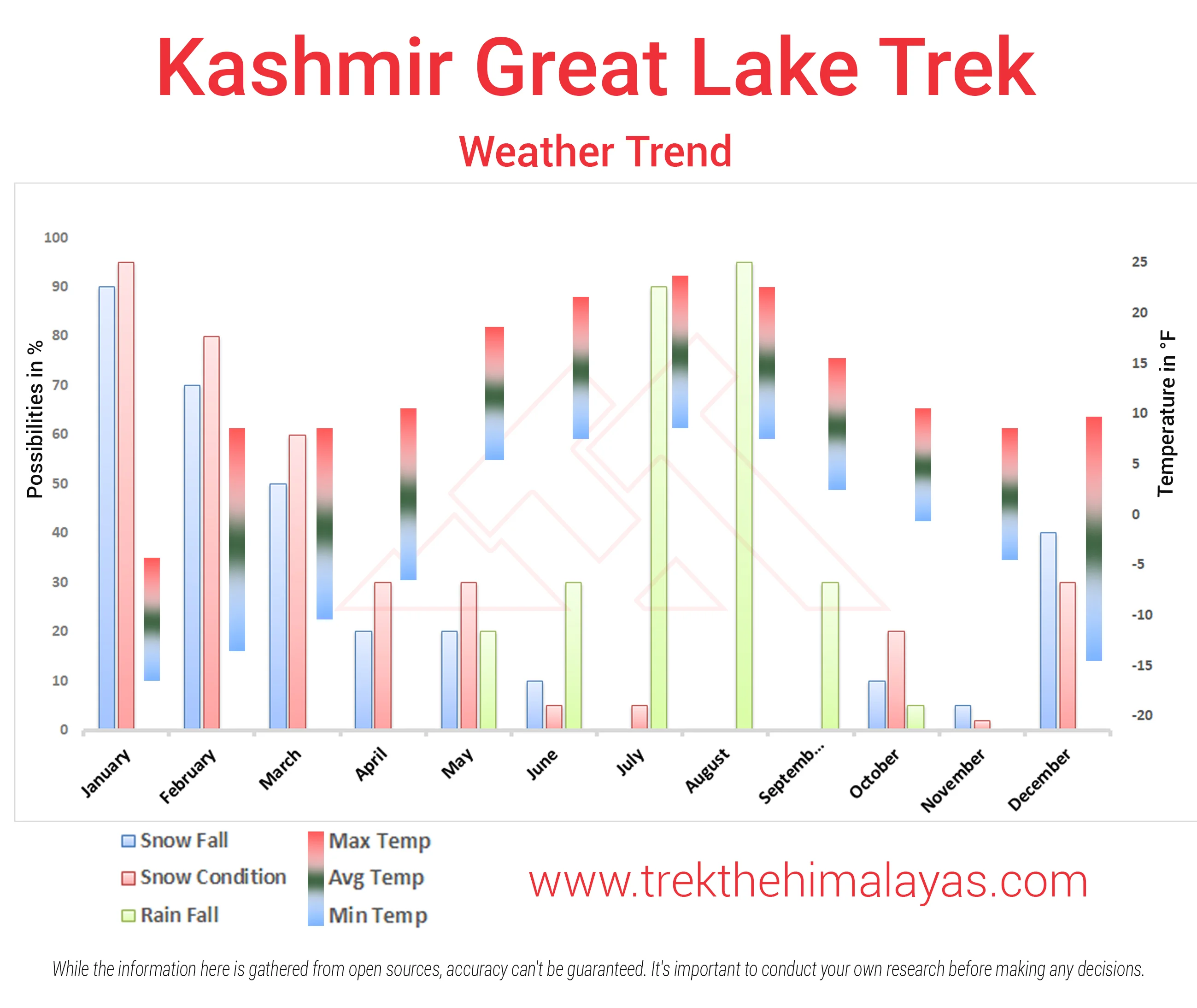
During trekking day time is always pleasant as temperature stay between 15C-22C throughout the season. At night time, temperature varies between 8 C to 0 C. Our morning, evening and nights are quite cold so you need to be prepared by wearing layers around camp. In early July, high chances of getting snow at Nichnai Pass and Gadsar pass and around. From July mid to August, almost snow melts by July end. And then around August end to September mid expected night temperature around 4 C to 0 C and one can expect snowfall around 2nd week of September. Do expect light shower around evening time.
Pick-up location is TRC: Nishad Garden in Srinagar at 12:00 Noon, TTH will take care of your further travel arrangements.
Options to Reach Srinagar: We advise you to reach Srinagar one day before trek date and by flight only. Better to avoid road route.
If you are planning to take a bus, you can reach ISBT in Srinagar from any major city. It will take 1 hour to reach Nishad garden from ISBT.
If you are planning to fly to Srinagar which is well connected to all major airports in India, you can reach TRC within 20 to 25 minutes via taxi.
If you’re coming by train, there are two railway stations.
Reporting point is Nishad Garden in Srinagar and Reporting time is 12:00 noon on trek date.
We always share driver and vehicle number 1 days prior the trek date, so you can call him on your arrival if you’re having problem with finding vehicle.
You can take out transport service; do contact your trek coordinator to book transport service. We use Sumo/Bolero/Max/Tavera or equivalent (shared by 6/7 people). We arrange vehicle depending on availability and final batch size.
Best time to do Kashmir Great Lakes Trek is July, August and September 2nd week. One can see lush green meadows, alpine lakes and beautiful colourful flowers. To enjoy it’s beauty, it is advisable to plan this trek July and August month. In September time one can see green meadows turning brown and flowers also changes its colour, but still this change in scenery is pleasing to watch.
Yes, we recommend KGL trek to first timer as well as experienced one. Make sure that you should have good fitness. People suffering from Bronchitis, Asthma, High blood pressure, Epilepsy (got faints), TB , Heart problem or on higher BMI side are strictly not allowed to go on any Himalayan trek. Apart from this if you had any medical history, please let us know.
No network while trekking. Idea, Airtel and BSNL networks available in Sonamarg and after that you will not get any network during the trek. Only post-paid connection works in Kashmir.
There isn’t any charging point on KGL trek. And you need to rely on your power bank or batteries.
Yes, it is necessary. It is additional support which helps you reduce tiredness and give you strength and balance.


